File:Rice fields, Vietnam ESA21898326.jpeg

Original file (13,814 × 9,722 pixels, file size: 24.33 MB, MIME type: image/jpeg)
Captions
Captions
Summary
[edit]
| Warning | The original file is very high-resolution. It might not load properly or could cause your browser to freeze when opened at full size. |
|---|
| Description |
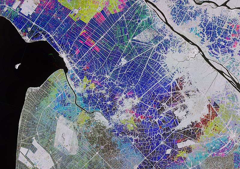
English: The Copernicus Sentinel-1 mission takes us over part of the Mekong Delta – a major rice-producing region in southwest Vietnam. In Vietnam, rice has been a strategic crop for national food security. Vietnam is the fifth largest producer of rice in the world, the majority of which is grown in the Mekong Delta – a vast flood plain and one of Asia’s most fertile agricultural zones. Such an enormous amount of rice is produced in the Mekong Delta that it is often referred to as Vietnam's 'rice bowl'. The rice grown here produces enough to make Vietnam the world's third biggest rice exporter – after India and Thailand. This multi-temporal image combines three radar acquisitions from the Copernicus Sentinel-1 mission taken around one month apart to show changes in crop and land conditions over time. The bright colours in the image come from changes on the ground that have occurred between acquisitions. Here, the first image, from 28 October 2019, picks out changes in pink and red, the second from 21 November shows changes in green, and the third image, from 27 December, shows changes in blue. As seen in the image, the majority of growth in the rice fields is visible in December. The grey areas represent either built-up areas or patches of land that saw no changes during this time. Bodies of water reflect the radar signal away from the satellite, making water appear dark. This can be seen in the Bassac River, also known as the Hau river, in the right of the image. Ships in the river can be seen as bright, multi-coloured dots. The combination of radar images from the Copernicus Sentinel-1 mission can help monitor and map the evolution of rice cultivation. Radar sensors are particularly useful owing to their ability to detect waterlogged ground and penetrate the humid cloud coverage typical of Asian rice-cultivating regions. This image is also featured on the Earth from Space video programme. |
| Date | Taken in 2019 |
| Source | Rice fields, Vietnam |
| Author | European Space Agency |
| Activity | Observing the Earth |
| Mission | Sentinel-1 |
| Set | Earth observation image of the week |
| System | Copernicus |
Licensing
[edit]

|
This image contains data from a satellite in the Copernicus Programme, such as Sentinel-1, Sentinel-2 or Sentinel-3. Attribution is required when using this image.
Attribution: Contains modified Copernicus Sentinel data 2019
The use of Copernicus Sentinel Data is regulated under EU law (Commission Delegated Regulation (EU) No 1159/2013 and Regulation (EU) No 377/2014). Relevant excerpts:
Free access shall be given to GMES dedicated data [...] made available through GMES dissemination platforms [...].
Access to GMES dedicated data [...] shall be given for the purpose of the following use in so far as it is lawful:
GMES dedicated data [...] may be used worldwide without limitations in time.
GMES dedicated data and GMES service information are provided to users without any express or implied warranty, including as regards quality and suitability for any purpose. |
This media was created by the European Space Agency (ESA).
Where expressly so stated, images or videos are covered by the Creative Commons Attribution-ShareAlike 3.0 IGO (CC BY-SA 3.0 IGO) licence, ESA being an Intergovernmental Organisation (IGO), as defined by the CC BY-SA 3.0 IGO licence. The user is allowed under the terms and conditions of the CC BY-SA 3.0 IGO license to Reproduce, Distribute and Publicly Perform the ESA images and videos released under CC BY-SA 3.0 IGO licence and the Adaptations thereof, without further explicit permission being necessary, for as long as the user complies with the conditions and restrictions set forth in the CC BY-SA 3.0 IGO licence, these including that:
See the ESA Creative Commons copyright notice for complete information, and this article for additional details.
|
 | |
This file is licensed under the Creative Commons Attribution-ShareAlike 3.0 IGO license. Attribution: ESA, CC BY-SA IGO 3.0
| ||
File history
Click on a date/time to view the file as it appeared at that time.
| Date/Time | Thumbnail | Dimensions | User | Comment | |
|---|---|---|---|---|---|
| current | 12:24, 6 June 2020 | | 13,814 × 9,722 (24.33 MB) | OptimusPrimeBot (talk | contribs) | #Spacemedia - Upload of https://www.esa.int/var/esa/storage/images/esa_multimedia/images/2020/03/rice_fields_vietnam/21898316-1-eng-GB/Rice_fields_Vietnam.jpg via Commons:Spacemedia |
You cannot overwrite this file.
File usage on Commons
There are no pages that use this file.