File:Rice-cropping systems in Vietnam’s Red River Delta ESA359048.jpg
Jump to navigation
Jump to search

Size of this preview: 764 × 599 pixels. Other resolutions: 306 × 240 pixels | 612 × 480 pixels | 979 × 768 pixels | 1,280 × 1,004 pixels | 2,560 × 2,008 pixels | 3,590 × 2,816 pixels.
Original file (3,590 × 2,816 pixels, file size: 3.49 MB, MIME type: image/jpeg)
Captions
Captions
Add a one-line explanation of what this file represents
Summary
[edit]
| Description |
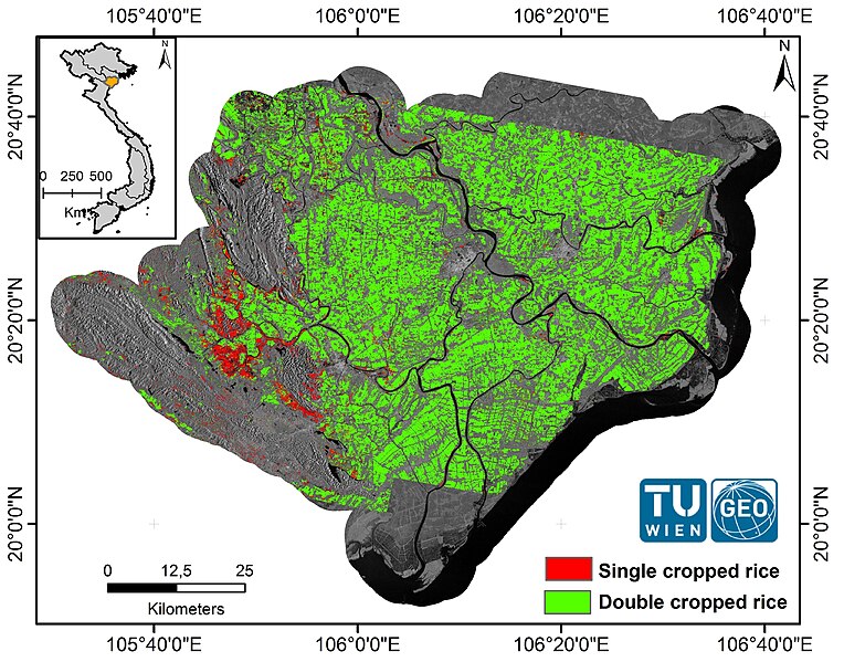
English: Intra-annual Sentinel-1 data from January 2015 to December 2015 were used to produce rice-cropping systems map in the Red River Delta, Vietnam. In this case study, a significant area of rice paddies grows two crops per year (green). The remaining areas, in mountainous and riverine regions (red), are where the long-term flooded or saturated soil conditions permitted only one crop of rice per year. |
| Date | |
| Source | http://www.esa.int/spaceinimages/Images/2016/04/Rice-cropping_systems_in_Vietnam_s_Red_River_Delta |
| Author | European Space Agency |
| Permission (Reusing this file) |
contains modified Copernicus Sentinel data (2015–16)/TU Wien,CC BY-SA 3.0 IGO |
| Title | Rice-cropping systems in Vietnam’s Red River Delta |
| Location | Vietnam |
| Mission | Sentinel-1 |
| Activity | Observing the Earth |
Licensing
[edit]
This file is licensed under the Creative Commons Attribution-ShareAlike 3.0 IGO license.
- You are free:
- to share – to copy, distribute and transmit the work
- to remix – to adapt the work
- Under the following conditions:
- attribution – You must give appropriate credit, provide a link to the license, and indicate if changes were made. You may do so in any reasonable manner, but not in any way that suggests the licensor endorses you or your use.
- share alike – If you remix, transform, or build upon the material, you must distribute your contributions under the same or compatible license as the original.
File history
Click on a date/time to view the file as it appeared at that time.
| Date/Time | Thumbnail | Dimensions | User | Comment | |
|---|---|---|---|---|---|
| current | 16:02, 6 May 2017 | | 3,590 × 2,816 (3.49 MB) | Fæ (talk | contribs) | == {{int:filedesc}} == {{information | description = {{en|1=Intra-annual Sentinel-1 data from January 2015 to December 2015 were used to produce rice-cropping systems map in the Red River Delta, Vietnam. In this case study, a significant area of... |
You cannot overwrite this file.
File usage on Commons
The following page uses this file: