File:Rheinkarte.JPG

Original file (3,055 × 3,099 pixels, file size: 2.3 MB, MIME type: image/jpeg)
Captions
Captions
Summary
[edit]
| Description |
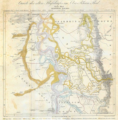
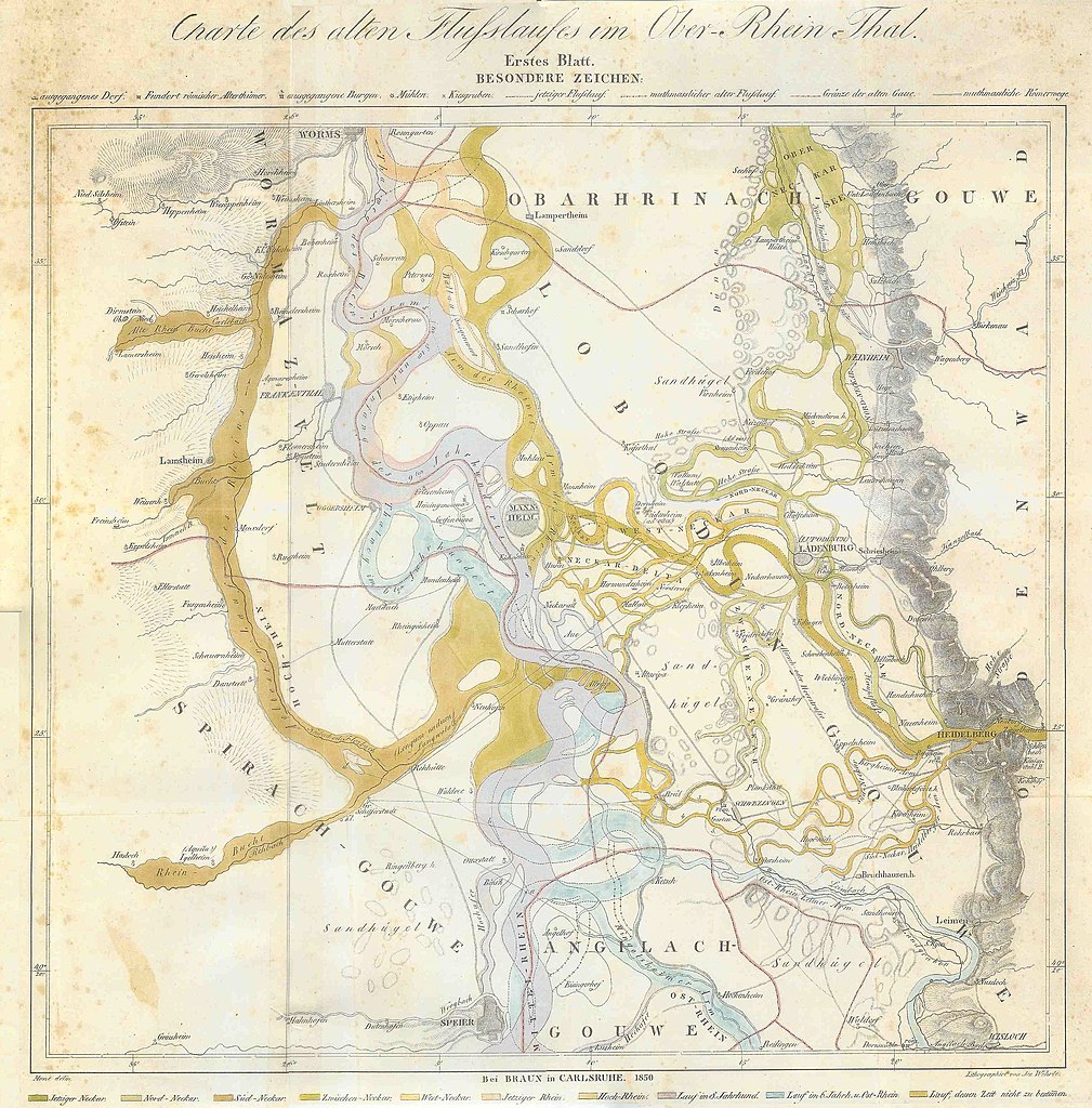
English: Historic map of different riverbeds of Rhine and Neckar from the 6th century until 1850
Deutsch: Historische Landkarte alter Flussläufe von Rhein und Neckar vom 6. Jahrhundert bis 1850, von Speyer und Heidelberg bis Worms
Originaltitel: Charte des alten Flußlaufes im Ober-Rhein-Thal Legende: (auch ganz unten auf der Karte, die Farbabstufungen sind nicht 100%ig wiederzuerkennen, aber die Karte ist gut beschriftet) Hellblau: Lauf im 6. Jahrhundert und Ost-Rhein Helles Lila: Lauf im 8. Jahrhundert Dunkelbraun: Hoch-Rhein Hellbraun: Jetziger Rhein (also 1850) Grasgrün: Zwischenneckar Grün-Braun: Süd-Neckar Hellgrün: Nord-Neckar Dunkelgrün: Jetziger Neckar (also 1850) |
| Date | |
| Source | published by BRAUN in Karlsruhe |
| Author | Litographirt von Jos. Wehrte (Originaltext) |
This map is stitched together from 4 scans I made in 2004, I just found on my harddrive. Also my "orginal" back then actually was a color copy that again was stitched together from 2 parts. Thus it might suffer from a lack of quality.
However, I have never seen any other map showing these different riverbeds so well.
If you have a real original, feel free to replace this!
| Camera location | | View this and other nearby images on: OpenStreetMap |
|---|
Licensing
[edit]
|
This work is in the public domain in its country of origin and other countries and areas where the copyright term is the author's life plus 70 years or fewer. | |
| This file has been identified as being free of known restrictions under copyright law, including all related and neighboring rights. | |
File history
Click on a date/time to view the file as it appeared at that time.
| Date/Time | Thumbnail | Dimensions | User | Comment | |
|---|---|---|---|---|---|
| current | 20:31, 28 February 2010 | | 3,055 × 3,099 (2.3 MB) | Knipptang (talk | contribs) | {{Information |Description={{en|1=Historic map of different riverbeds of Rhine and Neckar from the 6th century until 1850}} {{de|1=Historische Landkarte alter Flussläufe von Rhein und Neckar vom 6. Jahrhundert bis 1850}} |Source=published by BRAUN in Kar |
You cannot overwrite this file.
File usage on Commons
The following page uses this file:
File usage on other wikis
The following other wikis use this file:
- Usage on de.wikipedia.org