Category:Old maps of German Confederation
Jump to navigation
Jump to search
Media in category "Old maps of German Confederation"
The following 27 files are in this category, out of 27 total.
-
-
 1835 Malte-Brun Map of the German Confederation.jpg 3,751 × 2,946; 10.28 MB
-
 1837 Malte-Brun Map of Germany - Geographicus - GermanyNorth-mb-1837.jpg 2,355 × 1,746; 819 KB
-
 Carte Allemagne 1838.jpg 4,500 × 3,149; 8.28 MB
-
-
 1840 S.D.U.K. Map of Germany - Geographicus - Germany-sduk-1840.jpg 4,000 × 3,224; 4.76 MB
-

-

-

-
 Deutsche Bundesstaaten Platt 1848.pdf 2,418 × 2,977; 1.24 MB
-
 Schurz Map of Germany of the Reminiscences.png 680 × 1,055; 236 KB
-
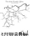
 Bahnkarte Deutschland 1849.jpg 4,646 × 3,766; 17.31 MB
-
 1866 Johnson Map of Prussia and Germany - Geographicus - Germany-johnson-1866.jpg 3,592 × 5,000; 6.51 MB
-
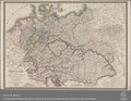
 (Spruner-Menke) Germany at the time of the German Federation, 1815 to 1866.jpg 3,376 × 2,792; 2.81 MB
-
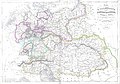
 (Putzger) Germany and German Confederation, 1815-1866.jpg 3,845 × 3,026; 1.98 MB
-
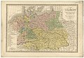
 (Meyer) Germany and German Confederation, 1815-1866.jpg 2,529 × 3,034; 1.41 MB
-

-

-
 Bahnkarte Deutschland 1861.jpg 4,878 × 3,792; 19.41 MB
-
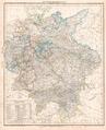
 Der Deutsche Bund 1828.jpg 5,136 × 3,654; 3.98 MB
-
 Friedrich List und die erste grosse Eisenbahn 2.jpg 1,683 × 2,064; 422 KB
-
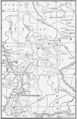
 German Confederation.jpg 1,174 × 889; 885 KB
-
 Grenze zwischen den Herzogthümern.png 5,407 × 1,837; 12.3 MB
-
 Meyers b4 s0772a.jpg 1,700 × 2,048; 756 KB
-
 Preußen 1440-1795 und 1807-1866.jpg 748 × 899; 181 KB
-
 Rheinkarte.JPG 3,055 × 3,099; 2.3 MB
-
 Spruner-Menke Handatlas 1880 Karte 49.jpg 10,465 × 8,737; 24.39 MB


_Germany_at_the_time_of_the_German_Federation,_1815_to_1866.jpg)
_Germany_and_German_Confederation,_1815-1866.jpg)
_Germany_and_German_Confederation,_1815-1866.jpg)
_(14594621807).jpg)
_(14780778762).jpg)


