File:Reliefkarte Battalaender.jpg
Jump to navigation
Jump to search

Size of this preview: 482 × 600 pixels. Other resolutions: 193 × 240 pixels | 386 × 480 pixels | 891 × 1,109 pixels.
Original file (891 × 1,109 pixels, file size: 278 KB, MIME type: image/jpeg)
Captions
Captions
Add a one-line explanation of what this file represents
Summary
[edit]
| Description |
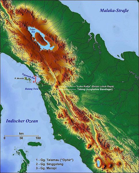
Deutsch: Reliefkarte nach Satellitenaufnahmen. Mit roten Strichen sind Junghuhns Peilungen zur Lagebestimmung des Vulkans "Lubu Radja" eingetragen. |
| Date | |
| Source | http://www.maps-for-free.com/ |
| Author | Karte: Hans Braxmeir; Ergänzungen und Änderungen von Geoethno |
Licensing
[edit]

|
Permission is granted to copy, distribute and/or modify this document under the terms of the GNU Free Documentation License, Version 1.2 or any later version published by the Free Software Foundation; with no Invariant Sections, no Front-Cover Texts, and no Back-Cover Texts. A copy of the license is included in the section entitled GNU Free Documentation License. |
Original upload log
[edit]
Transferred from de.wikipedia to Commons by Wdwdbot using script bot_filetrans.pl (r49M).
The original description page was here. All following user names refer to de.wikipedia.
- 2010-11-12 16:25:47 Geoethno (285028 Bytes) {{Information |Beschreibung = Reliefkarte nach Satellitenaufnahmen. Mit roten Strichen sind Junghuhns Peilungen zur Lagebestimmung des Vulkans "Lubu Radja" eingetragen. |Quelle = http://www.maps-for-free.com/ |Urheber = Ergänzungen und Änderungen von Ge
File history
Click on a date/time to view the file as it appeared at that time.
| Date/Time | Thumbnail | Dimensions | User | Comment | |
|---|---|---|---|---|---|
| current | 17:47, 16 May 2016 | | 891 × 1,109 (278 KB) | Wdwdbot (talk | contribs) | Bot Move: Original uploader of this revision (#1) was Geoethno at de.wikipedia |
You cannot overwrite this file.
File usage on Commons
There are no pages that use this file.