File:Reinos Antiguo Régimen.svg

Original file (SVG file, nominally 749 × 549 pixels, file size: 225 KB)
Captions
Captions
Summary
[edit]
| Description |
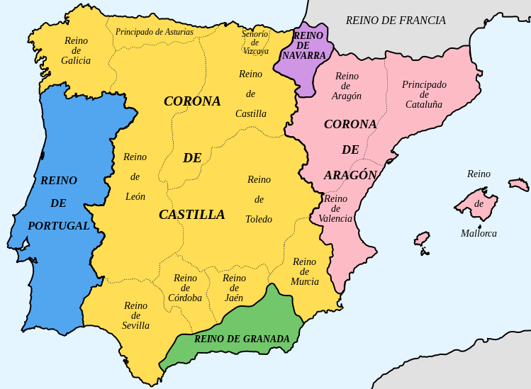
Español: División territorial de la Península Ibérica durante el Antiguo Régimen.
En azul, el reino de Portugal (incorporado a la Monarquía Hispánica entre 1580 y 1640). En naranja la Corona de Castilla y en rosa la Corona de Aragón (reunidas primero por el matrimonio de los Reyes Católicos y definitivamente por la herencia de Carlos V -1516-). En violeta el reino de Navarra (incorporado a Castilla en 1516). El reino de Galicia y el principado de Asturias no tenían existencia institucional, y pertenecían al reino de León (su representación en Cortes eran las ciudades de Zamora y León respectivamente). Además del señorío de Vizcaya, había dentro de la Corona de Castilla otras circunscripciones con título diferente al de reino, especialmente el condado de Álava y la provincia de Guipúzcoa (las tres eran llamadas provincias vascongadas o provincias exentas), y el señorío de Molina (este de la actual provincia de Guadalajara). La división en reinos dejó de tener trascendencia política con las reformas borbónicas (Felipe V, 1715). En la Edad Contemporánea, la organización territorial se basó en la división provincial de Javier de Burgos (1833). |
| Date | |
| Source |
This file was derived from:   |
| Author |
|
Licensing
[edit]
- You are free:
- to share – to copy, distribute and transmit the work
- to remix – to adapt the work
- Under the following conditions:
- attribution – You must give appropriate credit, provide a link to the license, and indicate if changes were made. You may do so in any reasonable manner, but not in any way that suggests the licensor endorses you or your use.
- share alike – If you remix, transform, or build upon the material, you must distribute your contributions under the same or compatible license as the original.
File history
Click on a date/time to view the file as it appeared at that time.
| Date/Time | Thumbnail | Dimensions | User | Comment | |
|---|---|---|---|---|---|
| current | 19:50, 6 December 2021 | | 749 × 549 (225 KB) | Martorell (talk | contribs) | Fixing southern borders of Kingdom of Valencia according to Treaty of Elx in 1304. |
| 03:16, 3 September 2020 |  | 749 × 549 (223 KB) | Milenioscuro (talk | contribs) | upload your own language version in other file | |
| 10:05, 2 September 2020 |  | 749 × 549 (200 KB) | LucasCYR (talk | contribs) | Reverted to version as of 10:02, 2 September 2020 (UTC) | |
| 10:04, 2 September 2020 |  | 749 × 549 (200 KB) | LucasCYR (talk | contribs) | Traduction en français | |
| 10:02, 2 September 2020 |  | 749 × 549 (200 KB) | LucasCYR (talk | contribs) | Traduction en français | |
| 20:55, 22 July 2018 |  | 749 × 549 (223 KB) | Milenioscuro (talk | contribs) | User created page with UploadWizard |
You cannot overwrite this file.
File usage on Commons
The following 3 pages use this file:
File usage on other wikis
The following other wikis use this file:
- Usage on ast.wikipedia.org
- Usage on ca.wikipedia.org
- Usage on ckb.wikipedia.org
- Usage on cs.wikipedia.org
- Usage on de.wikipedia.org
- Usage on en.wikipedia.org
- Usage on en.wikibooks.org
- Usage on es.wikipedia.org
- Usage on es.wikibooks.org
- Usage on fr.wikipedia.org
- Usage on gl.wikipedia.org
- Usage on nn.wikipedia.org
- Usage on no.wikipedia.org
- Usage on pt.wikipedia.org
- Usage on ro.wikipedia.org
- Usage on ru.wikipedia.org
- Usage on simple.wikipedia.org
Metadata
- Iberian kingdoms
- Maps of the history of Spain
- Maps of the Crown of Castile
- Maps of the Crown of Aragon
- Maps of the Kingdom of Aragon
- Maps of the Kingdom of Granada (Crown of Castile)
- Maps of Medieval Iberia
- Spanish-language SVG maps showing history of Europe
- Maps of the Kingdom of Galicia (Iberian Peninsula)
- Maps of 16th-century Iberian Peninsula