File:Regni Mexicani seu Novae Hispaniae, Ludovicianae, N. Angliae, Carolinae, Virginiae, Pensylvaniae, necnon insvlarvm archipelagi Mexicani in America Septentrionali - accurata tabula exhibita a NYPL434040.tiff
Jump to navigation
Jump to search

Size of this JPG preview of this TIF file: 686 × 600 pixels. Other resolutions: 275 × 240 pixels | 549 × 480 pixels | 879 × 768 pixels | 1,172 × 1,024 pixels | 2,343 × 2,048 pixels | 4,979 × 4,352 pixels.
Original file (4,979 × 4,352 pixels, file size: 62.17 MB, MIME type: image/tiff)
Captions
Captions
Add a one-line explanation of what this file represents
Summary
[edit]| Description | Regni Mexicani seu Novae Hispaniae, Ludovicianae, N. Angliae, Carolinae, Virginiae, Pensylvaniae, necnon insvlarvm archipelagi Mexicani in America Septentrionali / accurata tabula exhibita a Ioh. Baptista Homanno.; Maps of North America. / Parts | |||||||||||||||||||||||
| Notes | "Cum privilegio Sac. Caes. Maj." ''Note 2.'') Includes historical notes, decorative cartouche, and ill. ''Note 3.'') National Endowment for the Humanities Grant for Access to Early Maps of the Middle Atlantic Seaboard. ''Note 4.'') NYPL copy has ms. note in ink in upper right margin: 127. ''Note 5.'') Relief shown pictorially. | |||||||||||||||||||||||
| Item physical description | 1 map : hand col. ; 46 x 55 cm. | |||||||||||||||||||||||
| Catalogue call number | Map Div. 01-5233 [Filed with North America, [1750?], as originally cataloged in NYPL Dictionary Catalog of the Map Division] | |||||||||||||||||||||||
| Standard reference | Ill. in Portinaro and Knirsch. Cartography of North America, plate CXV; Lowery 473 | |||||||||||||||||||||||
| Date | between 1759 and 1784 | |||||||||||||||||||||||
| Source |
http://digitalgallery.nypl.org/nypldigital/dgkeysearchdetail.cfm?imageID=434040
|
|||||||||||||||||||||||
| Author | Johann Baptist, 1663-1724 -- Engraver Homann | |||||||||||||||||||||||
| Permission (Reusing this file) |
From The Lionel Pincus and Princess Firyal Map Division. http://maps.nypl.org
|
|||||||||||||||||||||||
| Location | Stephen A. Schwarzman Building / The Lionel Pincus and Princess Firyal Map Division | |||||||||||||||||||||||
| Digital item published | 2-3-2004; updated 3-25-2011 | |||||||||||||||||||||||
| Digital ID | 434040 | |||||||||||||||||||||||

The making of this file was supported by Wikimedia UK.
To see other files made with the support of Wikimedia UK, please see the category Supported by Wikimedia UK.
|
File history
Click on a date/time to view the file as it appeared at that time.
| Date/Time | Thumbnail | Dimensions | User | Comment | |
|---|---|---|---|---|---|
| current | 17:39, 13 December 2020 |  | 4,979 × 4,352 (62.17 MB) | Finavon (talk | contribs) | rotated |
| 09:12, 8 May 2014 | 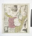 | 4,352 × 4,979 (62 MB) | Fæ (talk | contribs) | GWToolset: Creating mediafile for Fæ. Tranche 4 -4989 restart @08:55 BST, 7 May 2014 |
You cannot overwrite this file.
File usage on Commons
There are no pages that use this file.