File:Ramshaw Wood fort, Martyrs Hill, Buittle.jpg
Ramshaw_Wood_fort,_Martyrs_Hill,_Buittle.jpg (720 × 540 pixels, file size: 227 KB, MIME type: image/jpeg)
Captions
Captions
Summary
[edit]
| Description |
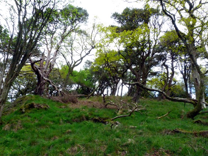
English: The Martyrs' Hill.
Marked as an ancient earthwork, the site contains the later gravesite attributed to some Covenanters. Forty years ago, having seen an iron age fort marked on the map, I climbed the hill and looked all round the slopes where I thought it was supposed to be, but couldn't see any sign of it....When I went back down the hill I mentioned it to the old gamekeeper's widow, who said, "That's the Martyrs' Hill, with the graves of the Covenanters on it." Later I realised I had been walking all over the site, which, naturally was on the hilltop instead of down the slopes where I expected it. Yesterday, I revisited what is apparently the site of the Covenanters' graves. It's a nicely 'mature' bit of hilltop woodland with Scots Pines and some lovely old oaks, blaeberries, mosses and loads of what George Peterken calls 'coarse deadwood' (CDW) a great indicator of natural forest conditions. (by Ed Iglehart) |
| Date | |
| Source | https://www.geograph.org.uk/photo/2943526 |
| Author | Ed Iglehart |
| Attribution (required by the license) | Ed Iglehart / The Martyrs' Hill / |
| Camera location | | View this and other nearby images on: OpenStreetMap |
|---|
Licensing
[edit]

|
This image was taken from the Geograph project collection. See this photograph's page on the Geograph website for the photographer's contact details. The copyright on this image is owned by Ed Iglehart and is licensed for reuse under the Creative Commons Attribution-ShareAlike 2.0 license.
|
- You are free:
- to share – to copy, distribute and transmit the work
- to remix – to adapt the work
- Under the following conditions:
- attribution – You must give appropriate credit, provide a link to the license, and indicate if changes were made. You may do so in any reasonable manner, but not in any way that suggests the licensor endorses you or your use.
- share alike – If you remix, transform, or build upon the material, you must distribute your contributions under the same or compatible license as the original.
REFER "Fifth Report and Inventory of Monuments and Constructions in Galloway" vol.II. County of the Stewartry of Kirkcudbright. https://archive.org/stream/cu31924015428661#page/n171/mode/2up
File history
Click on a date/time to view the file as it appeared at that time.
| Date/Time | Thumbnail | Dimensions | User | Comment | |
|---|---|---|---|---|---|
| current | 17:53, 20 July 2017 | | 720 × 540 (227 KB) | Bjh21 (talk | contribs) | Replace fuzzy upscaled picture with very slightly higher than usual resolution version from Geograph. |
| 00:45, 10 February 2013 |  | 1,280 × 960 (256 KB) | Scotire (talk | contribs) | User created page with UploadWizard |
You cannot overwrite this file.
File usage on Commons
There are no pages that use this file.