File:Rajendra map new de.svg
Jump to navigation
Jump to search

Size of this PNG preview of this SVG file: 800 × 573 pixels. Other resolutions: 320 × 229 pixels | 640 × 459 pixels | 1,024 × 734 pixels | 1,280 × 917 pixels | 2,560 × 1,834 pixels | 931 × 667 pixels.
Original file (SVG file, nominally 931 × 667 pixels, file size: 161 KB)
Captions
Captions
Add a one-line explanation of what this file represents
Summary
[edit]
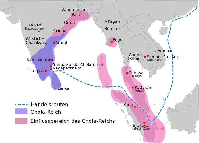
| Description | per http://cw.routledge.com/textbooks/9780415485432/15.asp "THE CŌḶAS" by K. A. Nilakanta Sastri and other histories of South Asia consulted |
| Date | |
| Source |
This file was derived from: Rajendra map new.svg |
| Author |
|
| Permission (Reusing this file) |
I, the copyright holder of this work, hereby publish it under the following license: This file is licensed under the Creative Commons Attribution-Share Alike 4.0 International license.
|
File history
Click on a date/time to view the file as it appeared at that time.
| Date/Time | Thumbnail | Dimensions | User | Comment | |
|---|---|---|---|---|---|
| current | 23:20, 17 July 2015 | | 931 × 667 (161 KB) | Furfur (talk | contribs) | == {{int:filedesc}} == {{Information |Description={{de|1=Karte des Chola-Reiches während der Regierungszeit Rajendra I. (c. 1030)}}{{en|Map showing the extent of the Chola empire during [[:en:Raje... |
You cannot overwrite this file.
File usage on Commons
The following page uses this file:
File usage on other wikis
The following other wikis use this file:
- Usage on de.wikipedia.org