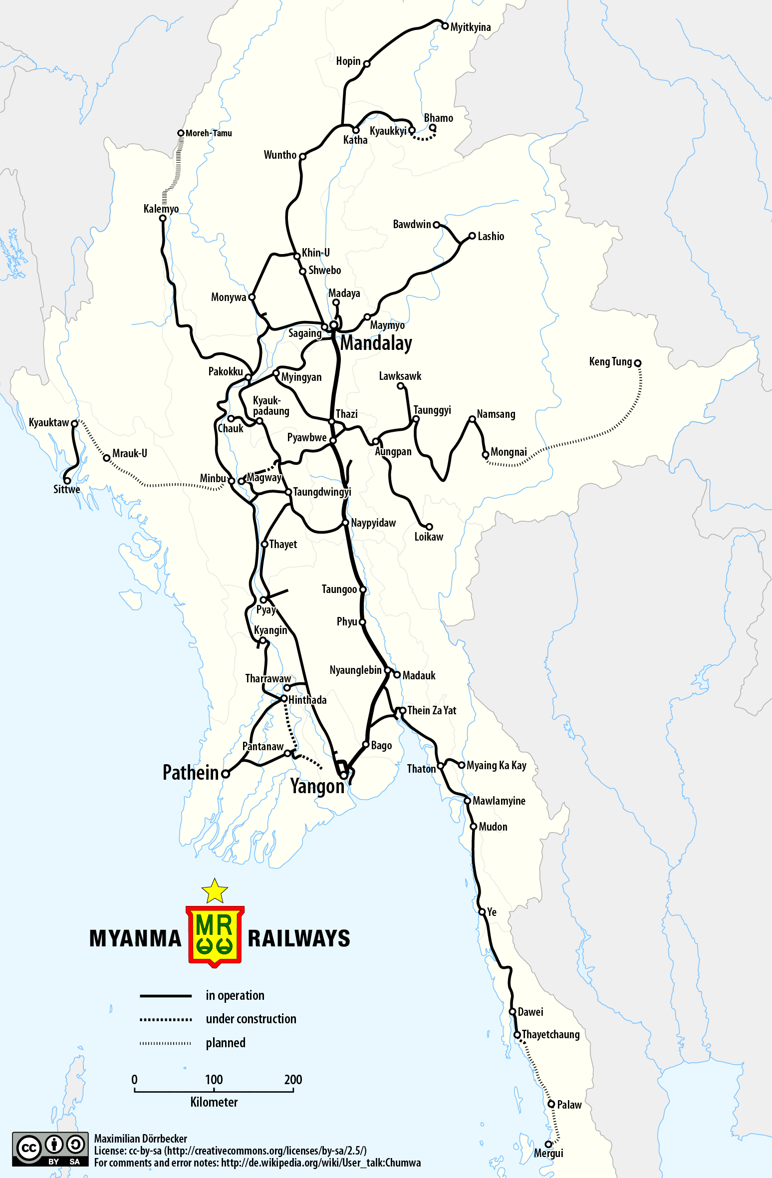
File:Railway map of Myanmar.png
Jump to navigation
Jump to search
Size of this preview: 393 × 600 pixels. Other resolutions: 157 × 240 pixels | 314 × 480 pixels | 503 × 768 pixels | 671 × 1,024 pixels | 1,547 × 2,360 pixels.
Original file (1,547 × 2,360 pixels, file size: 589 KB, MIME type: image/png)
Captions
Captions
Add a one-line explanation of what this file represents
| Description |
|
||
| Date | see file history | ||
| Source |
Own work using: |
||
| Author | Maximilian Dörrbecker (Chumwa) | ||
| Permission (Reusing this file) |
I, the copyright holder of this work, hereby publish it under the following license: This file is licensed under the Creative Commons Attribution-Share Alike 2.5 Generic license.
Sie dürfen das Bild zu den folgenden Bedingungen nutzen:
|

File history
Click on a date/time to view the file as it appeared at that time.
| Date/Time | Thumbnail | Dimensions | User | Comment | |
|---|---|---|---|---|---|
| current | 01:53, 13 March 2018 | | 1,547 × 2,360 (589 KB) | RaviC (talk | contribs) | + Kale - Moreh/Tamu under construction railway |
| 05:51, 25 May 2017 |  | 1,547 × 2,360 (525 KB) | Chumwa (talk | contribs) | {{Information |Description= *{{de|Eisenbahnkarte von Myanmar}} *{{en|Railway map of Myanmar}} |Source={{Own using}} *borders of Myanmar by {{U|Uwe Dedering}} *[http://www.myanmarailways1877.com/sites/default/files/Pla... |
You cannot overwrite this file.
File usage on Commons
The following 11 pages use this file:
- User:Chumwa/Gallery
- User:Chumwa/OgreBot/Potential transport maps/2017 May 21-31
- User:Chumwa/OgreBot/Potential transport maps/2018 March 11-20
- User:Chumwa/OgreBot/Public transport information/2017 May 21-31
- User:Chumwa/OgreBot/Public transport information/2018 March 11-20
- User:Chumwa/OgreBot/Transport Maps/2017 May 21-31
- User:Chumwa/OgreBot/Transport Maps/2018 March 11-20
- User:Chumwa/OgreBot/Travel and communication maps/2017 May 21-31
- User:Chumwa/OgreBot/Travel and communication maps/2018 March 11-20
- User:Chumwa/Railway maps
- Category:Rail transport in Myanmar
File usage on other wikis
The following other wikis use this file:
- Usage on de.wikipedia.org
- Usage on en.wikipedia.org
- Usage on ja.wikipedia.org
- Usage on no.wikipedia.org
- Usage on te.wikipedia.org
- Usage on th.wikipedia.org
- Usage on www.wikidata.org
- Usage on zh.wikipedia.org