
Category:Rail transport maps of Myanmar
Media in category "Rail transport maps of Myanmar"
The following 19 files are in this category, out of 19 total.
-
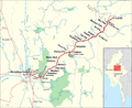 Bahnstrecke Mandalay–Lashio.png 3,000 × 2,447; 1.1 MB
-
 Circular train 02.jpg 1,249 × 1,846; 319 KB
-
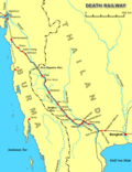 Death Railway.png 1,000 × 1,300; 530 KB
-
 Goteik viaduct.svg 596 × 488; 533 KB
-
 Linienentwicklung bei Sedaw.svg 1,442 × 668; 509 KB
-
 Map of POW camps along the Siam to Burma railway.jpg 781 × 1,134; 69 KB
-
 Myanmar Railways Division.png 2,048 × 3,227; 2.95 MB
-
 Myanmar Railways station map Division 1 Myitkyina.png 2,048 × 3,209; 2.71 MB
-
 Myanmar Railways station map Division 2 Ywa-Htaung.png 2,048 × 3,228; 4.03 MB
-
 Myanmar Railways stations map (composite).jpg 8,860 × 25,748; 89.58 MB
-
 Myanmar Railways' network map.jpg 527 × 954; 56 KB
-
 Railroads in Burma.jpg 542 × 1,222; 461 KB
-
 Railway map of Myanmar.png 1,547 × 2,360; 589 KB
-
 Railway Stations of Mandalay.svg 668 × 659; 339 KB
-
 Yangon Circular Railway and Suburban Rail.png 1,620 × 2,175; 353 KB
-
 Yangon Circular Railway Map (cropped).jpg 1,748 × 1,805; 1.38 MB
-
 Yangon Circular Railway Map in Train.JPG 3,343 × 4,464; 1.06 MB
-
 Yangon Circular Railway Map.jpg 4,032 × 3,024; 2.15 MB
-
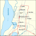
 Yangon Circular Railway.png 1,213 × 1,028; 760 KB


.jpg)


.jpg)