File:Railway bridge support, Newton Abbot - geograph.org.uk - 1184750.jpg
Jump to navigation
Jump to search
No higher resolution available.
Railway_bridge_support,_Newton_Abbot_-_geograph.org.uk_-_1184750.jpg (640 × 480 pixels, file size: 91 KB, MIME type: image/jpeg)
Captions
Captions
Add a one-line explanation of what this file represents
Summary
[edit]
| Description |
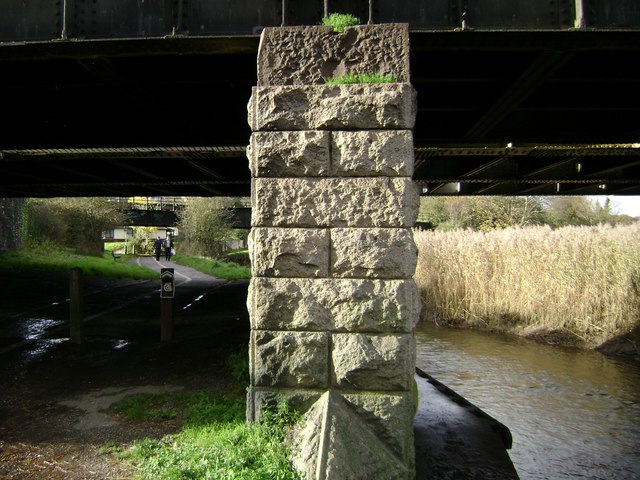
English: Railway bridge support, Newton Abbot. Templer Way, left, heads upstream and the River Lemon heads down to join the River Teign under the bridge carrying the main line between Exeter and Plymouth. The supporting pier is constructed of, or possibly clad with, the fine-grained grey Devonian limestone which was quarried around Torquay, Brixham and inland. The bridge in the distance carries the former, very scenic, GWR branch line from Newton Abbot to Moretonhampstead but which now ends at Bovey Heath SX8276 near Heathfield 13097. This is almost the furthest extent of the huge reedbeds at the head of the Teign estuary 703007. |
| Date | |
| Source | From geograph.org.uk |
| Author | Robin Stott |
| Attribution (required by the license) | Robin Stott / Railway bridge support, Newton Abbot / |
| Camera location | | View this and other nearby images on: OpenStreetMap |
|---|
_heading:292.00&language=en)
| Object location | | View this and other nearby images on: OpenStreetMap |
|---|
_heading:292.00&language=en)
Licensing
[edit]

|
This image was taken from the Geograph project collection. See this photograph's page on the Geograph website for the photographer's contact details. The copyright on this image is owned by Robin Stott and is licensed for reuse under the Creative Commons Attribution-ShareAlike 2.0 license.
|
This file is licensed under the Creative Commons Attribution-Share Alike 2.0 Generic license.
Attribution: Robin Stott
- You are free:
- to share – to copy, distribute and transmit the work
- to remix – to adapt the work
- Under the following conditions:
- attribution – You must give appropriate credit, provide a link to the license, and indicate if changes were made. You may do so in any reasonable manner, but not in any way that suggests the licensor endorses you or your use.
- share alike – If you remix, transform, or build upon the material, you must distribute your contributions under the same or compatible license as the original.
File history
Click on a date/time to view the file as it appeared at that time.
| Date/Time | Thumbnail | Dimensions | User | Comment | |
|---|---|---|---|---|---|
| current | 21:41, 25 February 2011 | | 640 × 480 (91 KB) | GeographBot (talk | contribs) | == {{int:filedesc}} == {{Information |description={{en|1=Railway bridge support, Newton Abbot Templer Way, left, heads upstream and the River Lemon heads down to join the River Teign under the bridge carrying the main line between Exeter and Plymouth. The |
You cannot overwrite this file.
File usage on Commons
There are no pages that use this file.