Category:Newton Abbot
Jump to navigation
Jump to search
market town and civil parish in Devon, England  | |||||
| Upload media | |||||
| Instance of | |||||
|---|---|---|---|---|---|
| Location | Teignbridge, Devon, South West England, England | ||||
| Official language | |||||
| Population |
| ||||
| Said to be the same as | Newton Abbot (Wikimedia duplicated page, civil parish) | ||||
| official website | |||||
 | |||||
Newton Abbot is a market town in w:Devon, w:England on the w:River Teign.
Subcategories
This category has the following 13 subcategories, out of 13 total.
Media in category "Newton Abbot"
The following 200 files are in this category, out of 1,730 total.
(previous page) (next page)-
 "Multiple camera's", Newton Abbot - geograph.org.uk - 4025066.jpg 1,920 × 1,505; 441 KB
-
 11 - 12, Courtenay Park Rd - geograph.org.uk - 5794998.jpg 640 × 425; 61 KB
-
 133 - 147, East St - geograph.org.uk - 5795034.jpg 640 × 426; 62 KB
-
 2017 at Teignbridge - crossing cottage.JPG 1,366 × 910; 448 KB
-
 83 Wolborough Street, Newton Abbot - geograph.org.uk - 4110417.jpg 640 × 427; 70 KB
-

-
 A balcony, Wolborough Hill, Newton Abbot - geograph.org.uk - 1384334.jpg 480 × 640; 411 KB
-
 A blast from the past - geograph.org.uk - 3255334.jpg 2,810 × 1,880; 773 KB
-
 A carpark off Wain Lane, Abbotsbury - geograph.org.uk - 3485250.jpg 800 × 600; 144 KB
-
 A damp lunch break - geograph.org.uk - 4767860.jpg 640 × 480; 124 KB
-
 A fine railway station - geograph.org.uk - 3920363.jpg 1,024 × 664; 122 KB
-
 A glimpse of Daracombe - geograph.org.uk - 1730080.jpg 640 × 480; 526 KB
-
 A Leat by the River Lemon - geograph.org.uk - 1509781.jpg 426 × 640; 138 KB
-
 A low point on Howton Road - geograph.org.uk - 1724788.jpg 640 × 480; 460 KB
-
 A Magnificent Tree on Old Totnes Road - geograph.org.uk - 2897707.jpg 2,998 × 3,111; 3.39 MB
-
 A small valley near Moorpark - geograph.org.uk - 1724790.jpg 640 × 480; 423 KB
-
 A wet field above Perry Farm - geograph.org.uk - 1724809.jpg 640 × 480; 404 KB
-
 A wet lane near Mallands - geograph.org.uk - 1723482.jpg 640 × 480; 131 KB
-
 A winding channel below Moorpark - geograph.org.uk - 1724793.jpg 640 × 480; 568 KB
-
 A380 - geograph.org.uk - 4504814.jpg 640 × 426; 49 KB
-
 A380 - geograph.org.uk - 5525970.jpg 640 × 425; 46 KB
-
 A380 - geograph.org.uk - 5744263.jpg 640 × 426; 51 KB
-
 A380 approaching Penn Inn - geograph.org.uk - 5304484.jpg 1,736 × 794; 268 KB
-
 A380 at Milber - geograph.org.uk - 3380687.jpg 640 × 347; 56 KB
-
 A380 Besigheim Way - geograph.org.uk - 5740239.jpg 1,024 × 759; 180 KB
-
 A380 Besigheim Way near Newton Abbot - geograph.org.uk - 5881427.jpg 800 × 600; 737 KB
-
 A380 Bridge - geograph.org.uk - 4307278.jpg 640 × 480; 52 KB
-
 A380 crosses the River Teign - geograph.org.uk - 3880810.jpg 3,501 × 2,373; 1.05 MB
-

-

-
 A380 junction with the road into Newton Abbot - geograph.org.uk - 5740231.jpg 1,024 × 754; 101 KB
-
-
 A380 north to Penn Inn - geograph.org.uk - 5740229.jpg 800 × 709; 81 KB
-
 A380 River Teign sign - geograph.org.uk - 5740322.jpg 1,187 × 609; 276 KB
-
 A380 roundabout junction with A381 - geograph.org.uk - 3880812.jpg 3,842 × 2,330; 1.3 MB
-
 A381 - geograph.org.uk - 3386823.jpg 640 × 430; 51 KB
-
 A381 - Torquay Road becomes East Street - geograph.org.uk - 3880817.jpg 3,112 × 2,545; 989 KB
-
 A381 approaches junction with Ogwell Road - geograph.org.uk - 3880829.jpg 3,410 × 2,340; 1.35 MB
-
 A381 at Newton Abbot - geograph.org.uk - 3333033.jpg 640 × 480; 59 KB
-

-
 A381 junction with Brunel Road - geograph.org.uk - 3880816.jpg 4,000 × 3,000; 2.29 MB
-
 A381 Newton Abbot - geograph.org.uk - 4513059.jpg 3,264 × 2,448; 2.25 MB
-
 Abbotsbury Road - geograph.org.uk - 4005824.jpg 3,529 × 2,520; 2.04 MB
-
 Across Newton Abbot - geograph.org.uk - 3330782.jpg 640 × 344; 42 KB
-
 Ad hoc development, Greycoat Lane - geograph.org.uk - 1730236.jpg 640 × 480; 352 KB
-
 Addison Rd, Newton Abbott - geograph.org.uk - 3098141.jpg 640 × 430; 85 KB
-
 Advance warning for junction off A380 - geograph.org.uk - 2291692.jpg 800 × 600; 385 KB
-
 Agricultural Building, Higher Staplehill - geograph.org.uk - 5915533.jpg 1,600 × 1,200; 546 KB
-
 Albion Hill - geograph.org.uk - 5795017.jpg 640 × 426; 69 KB
-
 Albion Hill, Newton Abbot - geograph.org.uk - 4111386.jpg 640 × 427; 75 KB
-
 Alder catkins by the Aller Brook - geograph.org.uk - 3332010.jpg 443 × 640; 57 KB
-
 Aldi, Newton Abbot - geograph.org.uk - 6302546.jpg 4,288 × 2,848; 1.28 MB
-
 All change - A380 - geograph.org.uk - 3920370.jpg 4,912 × 3,264; 4.94 MB
-
 All Saints (Marsh) C of E Primary School - geograph.org.uk - 3906158.jpg 1,276 × 813; 1.12 MB
-
 All Saints Church, High Week - geograph.org.uk - 5871922.jpg 640 × 480; 54 KB
-
 All Saints church, Highweek - geograph.org.uk - 3125417.jpg 640 × 480; 76 KB
-

-
 Aller Brake Road - geograph.org.uk - 1358486.jpg 640 × 429; 177 KB
-
 Aller Brake Road - geograph.org.uk - 3341649.jpg 640 × 480; 83 KB
-
 Aller Brake Road - geograph.org.uk - 4859324.jpg 1,920 × 1,205; 544 KB
-
 Aller Brake Road - geograph.org.uk - 4859344.jpg 1,920 × 1,140; 546 KB
-
 Aller Brook - geograph.org.uk - 3332017.jpg 640 × 502; 95 KB
-
 Aller Brook - geograph.org.uk - 3332028.jpg 640 × 480; 81 KB
-
 Aller Brook - geograph.org.uk - 3332032.jpg 640 × 419; 53 KB
-
 Aller Brook - geograph.org.uk - 3332165.jpg 497 × 640; 105 KB
-
 Aller Brook - geograph.org.uk - 3332240.jpg 509 × 640; 125 KB
-
 Aller Brook - geograph.org.uk - 4020759.jpg 1,920 × 1,440; 1,008 KB
-
 Aller Brook - geograph.org.uk - 5425190.jpg 640 × 426; 39 KB
-
 Aller Brook - geograph.org.uk - 5443695.jpg 640 × 426; 33 KB
-
 Aller Brook - geograph.org.uk - 833585.jpg 640 × 480; 115 KB
-
 Aller Brook - geograph.org.uk - 833731.jpg 480 × 640; 101 KB
-
 Aller Brook - Newton Abbot - geograph.org.uk - 410042.jpg 640 × 480; 81 KB
-
 Aller Brook Local Nature Reserve - geograph.org.uk - 1410723.jpg 640 × 475; 107 KB
-
 Aller Brook Local Nature Reserve - geograph.org.uk - 3331919.jpg 492 × 640; 126 KB
-
 Aller Brook Local Nature Reserve - geograph.org.uk - 834884.jpg 640 × 480; 133 KB
-
 Aller Brook near Penn Inn - geograph.org.uk - 4227314.jpg 640 × 425; 97 KB
-
 Aller Brook Valley - geograph.org.uk - 5606234.jpg 640 × 426; 50 KB
-
 Aller Brook, Newton Abbot - geograph.org.uk - 5259942.jpg 640 × 480; 80 KB
-
 Aller Junction - geograph.org.uk - 3669291.jpg 1,566 × 1,044; 813 KB
-
 Aller Junction - geograph.org.uk - 3669301.jpg 1,561 × 1,020; 720 KB
-
 Alley, Newton Abbot - geograph.org.uk - 3505202.jpg 493 × 640; 74 KB
-
 Alley, Newton Abbot - geograph.org.uk - 955675.jpg 504 × 640; 100 KB
-
 Allotment sheds, Wolborough Hill - geograph.org.uk - 5955992.jpg 4,288 × 2,848; 1.42 MB
-
 Allotments in Newton Abbot - geograph.org.uk - 30820.jpg 640 × 480; 179 KB
-
 Allotments, Wolborough Hill - geograph.org.uk - 6023133.jpg 4,288 × 2,848; 2.57 MB
-
 Allotments, Wolborough Hill - geograph.org.uk - 6023135.jpg 4,211 × 2,723; 1.77 MB
-
 Almost gone - geograph.org.uk - 3255337.jpg 2,809 × 1,877; 810 KB
-
 An old engine shed - geograph.org.uk - 6438945.jpg 1,024 × 681; 204 KB
-
 Animal sculpture, Seale Hayne - geograph.org.uk - 2015903.jpg 640 × 480; 104 KB
-
 Applegarth Avenue, Mile End - geograph.org.uk - 1730086.jpg 640 × 463; 378 KB
-

-
 Approach to Newton Abbott station - geograph.org.uk - 3906127.jpg 1,280 × 857; 1,024 KB
-
 Approaching Hennaborough - geograph.org.uk - 1614233.jpg 640 × 418; 76 KB
-
 Approaching Newton Abbot - geograph.org.uk - 3669254.jpg 1,574 × 1,044; 707 KB
-
 Approaching Powderham Road, Newton Abbot - geograph.org.uk - 1655644.jpg 640 × 427; 296 KB
-
 Approaching Town Quay - geograph.org.uk - 3903546.jpg 1,280 × 857; 1.24 MB
-
 Arable field near Abbotskerswell - geograph.org.uk - 4822375.jpg 1,920 × 1,313; 909 KB
-
 Asda and parking area - geograph.org.uk - 3798638.jpg 640 × 425; 72 KB
-
 Asda Car Park Newton Abbot - geograph.org.uk - 5095725.jpg 640 × 480; 69 KB
-
 Asda stores, Newton Abbot - geograph.org.uk - 4735373.jpg 1,600 × 1,200; 1.25 MB
-
 Ashburton Road at Hele Park - geograph.org.uk - 3485288.jpg 800 × 600; 185 KB
-
 Ashill - geograph.org.uk - 5458239.jpg 3,072 × 2,048; 1.05 MB
-

-

-
 At the waters edge - April 2015 - panoramio.jpg 4,000 × 3,000; 3.71 MB
-

-
 Austins, Newton Abbot - geograph.org.uk - 3731430.jpg 2,618 × 3,418; 1.26 MB
-
 Auto Doc, Newton Abbot - geograph.org.uk - 6062493.jpg 2,610 × 2,082; 553 KB
-
 Auto trade businesses - geograph.org.uk - 3920367.jpg 1,600 × 1,000; 169 KB
-
 Autumn colour in Baker's Park, Newton Abbot - geograph.org.uk - 3747493.jpg 2,501 × 2,289; 2.94 MB
-
 Autumn trees, Forde Park - geograph.org.uk - 4265203.jpg 4,000 × 3,000; 2.52 MB
-
 Autumn trees, Forde Park - geograph.org.uk - 4265220.jpg 3,000 × 4,000; 2.38 MB
-
 B3195, Newton Abbot - geograph.org.uk - 5799650.jpg 640 × 426; 41 KB
-
 Back alley, Newton Abbot - geograph.org.uk - 3505183.jpg 441 × 640; 101 KB
-
 Back alley, Newton Abbot - geograph.org.uk - 3505193.jpg 480 × 640; 71 KB
-
 Back alley, Newton Abbot - geograph.org.uk - 5788833.jpg 2,485 × 3,319; 1.02 MB
-
 Back alley, Newton Abbot - geograph.org.uk - 5788885.jpg 4,288 × 2,848; 2.58 MB
-
 Back alley, Newton Abbot - geograph.org.uk - 5789003.jpg 2,654 × 3,706; 1.67 MB
-
 Back alley, Newton Abbot - geograph.org.uk - 5789082.jpg 4,125 × 2,496; 2.05 MB
-
 Baffled dog at footpath junction - geograph.org.uk - 1612581.jpg 640 × 490; 108 KB
-
 Baker's Park - geograph.org.uk - 800160.jpg 480 × 640; 126 KB
-
 Baker's Park, Newton Abbot - geograph.org.uk - 2072696.jpg 640 × 480; 206 KB
-
 Baker's Park, Newton Abbot - geograph.org.uk - 518433.jpg 640 × 480; 75 KB
-
 Bakers Park Gates.jpg 6,000 × 4,000; 12.76 MB
-
 Bakers Park, Newton Abbot.jpg 6,000 × 4,000; 12.23 MB
-
 Bales - geograph.org.uk - 5726141.jpg 640 × 426; 45 KB
-
 Bandstand, Courtenay Park - geograph.org.uk - 3386849.jpg 640 × 430; 54 KB
-
 Bandstand, Courtenay Park - geograph.org.uk - 5794990.jpg 640 × 425; 73 KB
-
 Bandstand, Courtenay Park - geograph.org.uk - 5794991.jpg 640 × 426; 65 KB
-
 Bank erosion, River Lemon - geograph.org.uk - 6493975.jpg 4,288 × 2,848; 2.03 MB
-
 Bank Street, Newton Abbot - geograph.org.uk - 4373394.jpg 1,920 × 2,520; 690 KB
-
 Bank Street, Newton Abbot - geograph.org.uk - 5427396.jpg 1,280 × 851; 355 KB
-
 Banners on the fence - geograph.org.uk - 3906107.jpg 1,280 × 789; 899 KB
-

-
 Barn at Ashill - geograph.org.uk - 1724878.jpg 640 × 480; 534 KB
-
 Barn, Higher Staplehill - geograph.org.uk - 5558828.jpg 3,072 × 2,048; 866 KB
-
 Barn, Higher Staplehill - geograph.org.uk - 900956.jpg 480 × 640; 110 KB
-
 Barns and stores, Higher Staplehill - geograph.org.uk - 1723896.jpg 640 × 480; 428 KB
-
 Barred footpath, Morley - geograph.org.uk - 6414263.jpg 2,848 × 4,288; 2.43 MB
-
 Battered Bridge - geograph.org.uk - 2881963.jpg 640 × 429; 67 KB
-
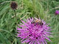 Bee on Knapweed - geograph.org.uk - 503474.jpg 640 × 480; 89 KB
-
 Bee orchid - geograph.org.uk - 3012747.jpg 429 × 640; 46 KB
-
 Bee orchid - geograph.org.uk - 3012758.jpg 429 × 640; 49 KB
-
 Bee Orchid, Aller Brook Local Nature Reserve - geograph.org.uk - 4020530.jpg 1,774 × 2,166; 299 KB
-

-

-
 Bee Orchid, Brunel Industrial Estate - geograph.org.uk - 4020829.jpg 1,840 × 2,154; 604 KB
-

-
 Beech and chimneys, Newton Abbot - geograph.org.uk - 3264469.jpg 480 × 640; 138 KB
-
 Beech tree, Newton Abbot - geograph.org.uk - 1041746.jpg 640 × 480; 113 KB
-
 Beech woodland west of Decoy Lake - geograph.org.uk - 800366.jpg 640 × 480; 153 KB
-
 Belmont Road, Newton Abbot - geograph.org.uk - 3647061.jpg 442 × 640; 58 KB
-
 Belvedere Road in Highweek, Newton Abbot - geograph.org.uk - 3398674.jpg 1,024 × 768; 114 KB
-
 Ben Stedham's Wood - geograph.org.uk - 229133.jpg 480 × 640; 169 KB
-
 Bench, Newton Abbot station - geograph.org.uk - 4689172.jpg 1,920 × 1,280; 538 KB
-
 Bench, Wolborough churchyard - geograph.org.uk - 6513816.jpg 4,288 × 2,848; 2.47 MB
-
 Berendsen Linen Hire - geograph.org.uk - 5747145.jpg 1,531 × 984; 282 KB
-
 Beside Aller Brook - geograph.org.uk - 3669267.jpg 1,572 × 1,044; 785 KB
-
 Between the lines, Newton Abbot - geograph.org.uk - 1915559.jpg 640 × 480; 109 KB
-
 Bicycles at Newton Abbot station - geograph.org.uk - 5278446.jpg 2,986 × 1,899; 1.08 MB
-
 Blackball Plantation - geograph.org.uk - 1612794.jpg 640 × 502; 90 KB
-
 Blackball Plantation - geograph.org.uk - 5393594.jpg 2,448 × 3,264; 2.41 MB
-
 Blackball Plantation - geograph.org.uk - 5393606.jpg 2,448 × 3,264; 2.65 MB
-
 Blake's Field allotments - geograph.org.uk - 6023136.jpg 4,288 × 2,848; 2.11 MB
-
 Bluff southeast of Greenhill Farm - geograph.org.uk - 1724819.jpg 640 × 480; 421 KB
-
 Boatload of daffodils - geograph.org.uk - 4377437.jpg 5,184 × 3,456; 3.33 MB
-
 Bottom of Powderham Road (4259830803).jpg 3,264 × 2,448; 3.58 MB
-

-
 Bowden Hill, Newton Abbot - geograph.org.uk - 5845723.jpg 640 × 480; 77 KB
-
 BQ on a bright Sunday morning - geograph.org.uk - 2723735.jpg 640 × 406; 73 KB
-
 Bradley Lane, Newton Abbot - geograph.org.uk - 6638158.jpg 640 × 480; 70 KB
-
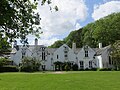 Bradley Manor - the east front - geograph.org.uk - 4503683.jpg 4,000 × 3,000; 1.39 MB
-
 Bradley Manor House - geograph.org.uk - 3115937.jpg 800 × 600; 120 KB
-
 Bradley Manor Lodge (geograph 6569472).jpg 4,107 × 2,188; 910 KB
-
 Bradley Manor near Newton Abbot, Devon - geograph.org.uk - 4697518.jpg 4,000 × 3,000; 5.63 MB
-
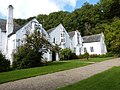 Bradley Manor, near Newton Abbot, Devon - geograph.org.uk - 4697514.jpg 3,978 × 2,970; 5.63 MB
-
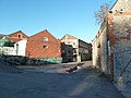 Bradley Mills, Bradley Lane - geograph.org.uk - 2226232.jpg 640 × 480; 72 KB
-
 Bradley Mills, Bradley Lane - geograph.org.uk - 2226237.jpg 640 × 480; 65 KB
-
 Bradley Mills, Bradley Lane - geograph.org.uk - 2226245.jpg 640 × 480; 59 KB
-
 Bradley Mills, Newton Abbot - geograph.org.uk - 4767863.jpg 640 × 480; 59 KB
-
 Bradley Mills, Newton Abbot - geograph.org.uk - 5847993.jpg 640 × 480; 104 KB
-
 Bradley Mills, Newton Abbot - geograph.org.uk - 6637795.jpg 640 × 480; 100 KB
-
 Bradley Mills, Newton Abbot - geograph.org.uk - 6638114.jpg 640 × 480; 98 KB
-
 Bradley Mills, Newton Abbot - geograph.org.uk - 6638124.jpg 640 × 480; 85 KB
-
 Bradley Mills, Newton Abbot - geograph.org.uk - 6638134.jpg 480 × 640; 75 KB
-
 Bradley Mills, Newton Abbot - geograph.org.uk - 6638143.jpg 480 × 640; 65 KB
-
 Bradley Mills, Newton Abbot - geograph.org.uk - 6638170.jpg 640 × 480; 102 KB
-
 Bradley Road, Newton Abbot - geograph.org.uk - 6569427.jpg 3,760 × 2,245; 1.13 MB
-
 Bradley valley - geograph.org.uk - 1358458.jpg 640 × 429; 205 KB
-
 Bradley Woods Newton Abbott England.jpg 1,075 × 850; 226 KB
-
 Bradley Woods, Newton Abbott, England-LCCN2002708009.jpg 3,700 × 2,800; 3.77 MB
-
 Brick terraces, Newton Abbot - geograph.org.uk - 3505166.jpg 640 × 446; 59 KB
-

-
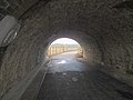 Bridge under railway, Newton Abbot - geograph.org.uk - 3341286.jpg 640 × 480; 52 KB
-
 British Heart Foundation, Newton Abbot - geograph.org.uk - 5533479.jpg 1,643 × 2,625; 593 KB
-

-
-

-
 Brunel's Legacy - geograph.org.uk - 2882006.jpg 640 × 429; 66 KB
-
 BRUTEs at Newton Abbot market.jpg 1,024 × 768; 393 KB


_C_of_E_Primary_School_-_geograph.org.uk_-_3906158.jpg)


.jpg)


.jpg)


,_RP-F-F04629.jpg)


