File:Queens, Vol. 1, Double Page Plate No. 29; Part of Ward 4; Jamaica; Sub Plan; (Map bounded by Merrick Road, Cumberland St., Carmen PL., Highview PL., Highview Ave., South St; Including Merrick NYPL1693872.tiff
Jump to navigation
Jump to search

Size of this JPG preview of this TIF file: 800 × 593 pixels. Other resolutions: 320 × 237 pixels | 640 × 474 pixels | 1,024 × 759 pixels | 1,280 × 948 pixels | 2,560 × 1,897 pixels | 6,888 × 5,104 pixels.
Original file (6,888 × 5,104 pixels, file size: 100.59 MB, MIME type: image/tiff)
Captions
Captions
Add a one-line explanation of what this file represents
Summary
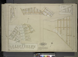
[edit]| Description | Queens, Vol. 1, Double Page Plate No. 29; Part of Ward 4; Jamaica; Sub Plan; [Map bounded by Merrick Road, Cumberland St., Carmen PL., Highview PL., Highview Ave., South St.; Including Merrick Plank Road, Hobson St., Dewey Ave., Samuel St., Gilbert St., George St., Adolph St., Theodore St., Herbert St., Watson Ave., Baldwin Ave., Borough Lane, Rosevelt Ave.]; Sub Plan From Plate No. 18; [Map bounded by Locust Ave., Waldron St., Forman Ave., Stevens St., Stewart St.; Including Duane St., Tremont St., Rutland St., Central Ave., Leslie Ave., Gordon St., Irving Ave., Wilton Ave., Caxton Ave.]; Sub Plan From Plate No. 18; [Map bounded by Farmers Ave., Heath St., Randolph St., Wright St., Golder St., bennett St., Carmen St., Nicholas St., Pemberton St., Derby St., New York Ave., Higbie Ave.; Including Merrick Ave., Anita PL., Nadal PL., Humphry PL., Nostrand PL., Pacific St., Scutt PL., Vine St., Short St.]; Sub Plan From Plate No. 18; [Map bounded by Leslie St., Farmers Ave., Merrick Road, Arlington St., Anderson St.; Zoller St., 11th St., Ray PL., Sidway St., Stanley St.]; Atlases of New York city. / Atlas of the borough of Queens, city of New York : based upon official plans and maps on file in the various city offices; supplemented by careful field measurements and personal observations / by and under the supervision of Hugo Ullitz. / Fourth and fifth wards: Jamaica and Rockaway. | |||||||||||||||||||||||
| Catalogue call number | Map Div.+++ (Queens, New York. 1912-1913) (Hyde, E.B., Map Co., Inc. Atlas of the borough of Queens) | |||||||||||||||||||||||
| Item/Page/Plate | 29 | |||||||||||||||||||||||
| Date | between 1907 and 1908 | |||||||||||||||||||||||
| Source |
http://digitalgallery.nypl.org/nypldigital/dgkeysearchdetail.cfm?imageID=1693872
|
|||||||||||||||||||||||
| Author | ||||||||||||||||||||||||
| Permission (Reusing this file) |
From The Lionel Pincus and Princess Firyal Map Division. http://maps.nypl.org
|
|||||||||||||||||||||||
| Location | Stephen A. Schwarzman Building / The Lionel Pincus and Princess Firyal Map Division | |||||||||||||||||||||||
| Digital item published | 2-27-2009; updated 3-25-2011 | |||||||||||||||||||||||
| Digital ID | 1693872 | |||||||||||||||||||||||

The making of this file was supported by Wikimedia UK.
To see other files made with the support of Wikimedia UK, please see the category Supported by Wikimedia UK.
|
File history
Click on a date/time to view the file as it appeared at that time.
| Date/Time | Thumbnail | Dimensions | User | Comment | |
|---|---|---|---|---|---|
| current | 15:28, 8 May 2014 |  | 6,888 × 5,104 (100.59 MB) | Fæ (talk | contribs) | GWToolset: Creating mediafile for Fæ. Tranche 4 -4989 restart @08:55 BST, 7 May 2014 |
You cannot overwrite this file.
File usage on Commons
There are no pages that use this file.