File:Preussen-1806.jpg
Jump to navigation
Jump to search
Size of this preview: 800 × 402 pixels. Other resolutions: 320 × 161 pixels | 640 × 321 pixels | 1,000 × 502 pixels.
Original file (1,000 × 502 pixels, file size: 187 KB, MIME type: image/jpeg)
Captions
Captions
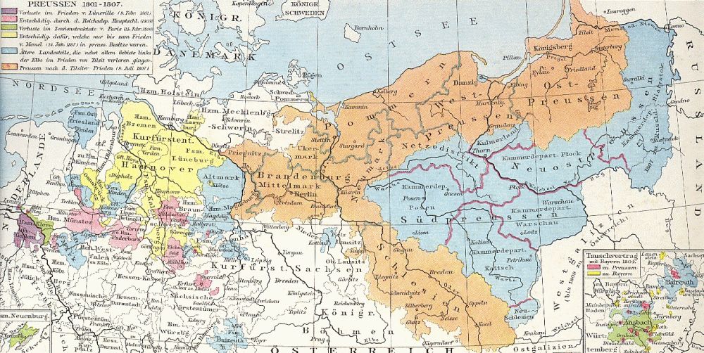
Map of Prussia & vicinity, 1801..1807.
Summary
[edit]
| Description |
Deutsch: Preußen, Gebietsverluste zwischen 1801 und 1807 English: Prussia, 1801-1807 |
| Date | |
| Source | G. Droysens Historischer Handatlas |
| Author | O. Meinke |
Originally found at de:Bild:Preussen-1806.jpg
Licensing
[edit]
|
This work is in the public domain in its country of origin and other countries and areas where the copyright term is the author's life plus 70 years or fewer. | |
| This file has been identified as being free of known restrictions under copyright law, including all related and neighboring rights. | |
File history
Click on a date/time to view the file as it appeared at that time.
| Date/Time | Thumbnail | Dimensions | User | Comment | |
|---|---|---|---|---|---|
| current | 03:29, 25 November 2007 | | 1,000 × 502 (187 KB) | Olessi (talk | contribs) | {{Information |Description=Prussia, 1801-1807 |Source=Historischer Handatlas |Date=1886 |Author=Gustav von Droysen, O. Meinke |Permission= |other_versions= }} |
You cannot overwrite this file.
File usage on Commons
The following 2 pages use this file:
File usage on other wikis
The following other wikis use this file:
- Usage on ar.wikipedia.org
- Usage on azb.wikipedia.org
- Usage on da.wikipedia.org
- Usage on de.wikipedia.org
- Usage on el.wikipedia.org
- Usage on en.wikipedia.org
- Usage on et.wikipedia.org
- Usage on fr.wikipedia.org
- Usage on he.wikipedia.org
- Usage on it.wikipedia.org
- Usage on la.wikipedia.org
- Usage on lt.wikipedia.org
- Usage on mk.wikipedia.org
- Usage on nn.wikipedia.org
- Usage on no.wikipedia.org
- Usage on pl.wikipedia.org
- Usage on pt.wikipedia.org
- Usage on ru.wikipedia.org
View more global usage of this file.