File:PolskySpis-hu.svg
Jump to navigation
Jump to search

Size of this PNG preview of this SVG file: 629 × 599 pixels. Other resolutions: 252 × 240 pixels | 504 × 480 pixels | 806 × 768 pixels | 1,075 × 1,024 pixels | 2,151 × 2,048 pixels.
Original file (SVG file, nominally 629 × 599 pixels, file size: 246 KB)
Captions
Captions
Add a one-line explanation of what this file represents
| Description |
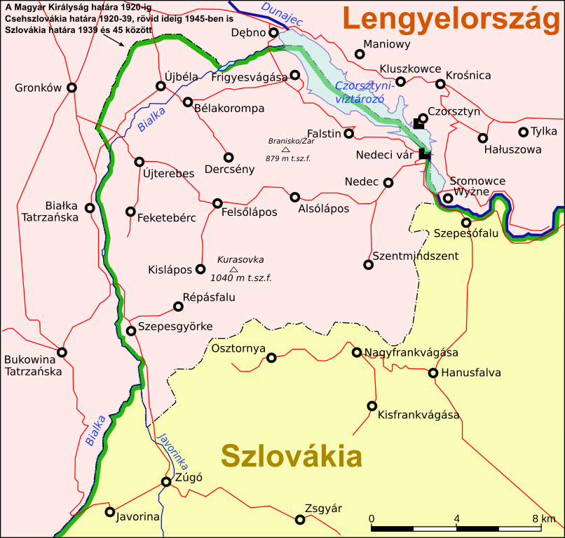
English: Polish part of Spis region as of 1920-1939 and after 1945. Slovenčina: Poľská časť Spiša od 28.júla 1920 do 1.septembra/24.novembra 1939 a od 20.mája 1945. |
| Date | (UTC) |
| Source | |
| Author |
|
| Other versions |
|


| This is a retouched picture, which means that it has been digitally altered from its original version. Modifications: Hungarian translation. The original can be viewed here: PolskySpis.svg:
|
I, the copyright holder of this work, hereby publish it under the following licenses:
This file is licensed under the Creative Commons Attribution-Share Alike 3.0 Unported license.
- You are free:
- to share – to copy, distribute and transmit the work
- to remix – to adapt the work
- Under the following conditions:
- attribution – You must give appropriate credit, provide a link to the license, and indicate if changes were made. You may do so in any reasonable manner, but not in any way that suggests the licensor endorses you or your use.
- share alike – If you remix, transform, or build upon the material, you must distribute your contributions under the same or compatible license as the original.

|
Permission is granted to copy, distribute and/or modify this document under the terms of the GNU Free Documentation License, Version 1.2 or any later version published by the Free Software Foundation; with no Invariant Sections, no Front-Cover Texts, and no Back-Cover Texts. A copy of the license is included in the section entitled GNU Free Documentation License. |
You may select the license of your choice.
== Original upload log ==
This image is a derivative work of the following images:
- File:PolskySpis.svg licensed with Cc-by-sa-3.0, GFDL
- 2009-08-20T09:30:48Z Kristo 656x625 (158566 Bytes)
- 2009-08-20T09:19:53Z Kristo 656x625 (158567 Bytes) [[Category:Maps of the history of Slovakia]] [[Category:SVG maps of Slovakia]] [[Category:Spiš]]
- 2009-08-19T13:02:12Z Kristo 656x625 (157545 Bytes) {{Information |Description={{en|1=Polish part of Spis region as of 1920-1939 and after 1945. }} {{sk|1=Poľská časť Spiša od 28.júla 1920 do 1.septembra/24.novembra 1939 a od 20.mája 1945.}} |Source=Own work by uploader
Uploaded with derivativeFX
File history
Click on a date/time to view the file as it appeared at that time.
| Date/Time | Thumbnail | Dimensions | User | Comment | |
|---|---|---|---|---|---|
| current | 12:45, 26 September 2012 | | 629 × 599 (246 KB) | Piroska (talk | contribs) | Correcting some labels |
| 19:18, 17 May 2010 |  | 656 × 625 (298 KB) | Piroska (talk | contribs) | Transforming some labels to chains. | |
| 19:39, 13 May 2010 |  | 656 × 625 (169 KB) | Piroska (talk | contribs) | {{Information |Description={{en|1=Polish part of Spis region as of 1920-1939 and after 1945. }} {{sk|1=Poľská časť Spiša od 28.júla 1920 do 1.septembra/24.novembra 1939 a od 20.mája 1945.}} |Source=*File:PolskySpis.svg |Date=2010-05-13 19:37 |
You cannot overwrite this file.
File usage on Commons
The following page uses this file:
File usage on other wikis
The following other wikis use this file:
- Usage on hu.wikipedia.org