File:Polish-Lithuanian Commonwealth (1619) compared with today's borders (Russian version).png
Original file (3,133 × 2,997 pixels, file size: 296 KB, MIME type: image/png)
Captions
Captions
Summary
[edit]_compared_with_today%27s_borders_(Russian_version).png&action=edit§ion=1)
| Description |
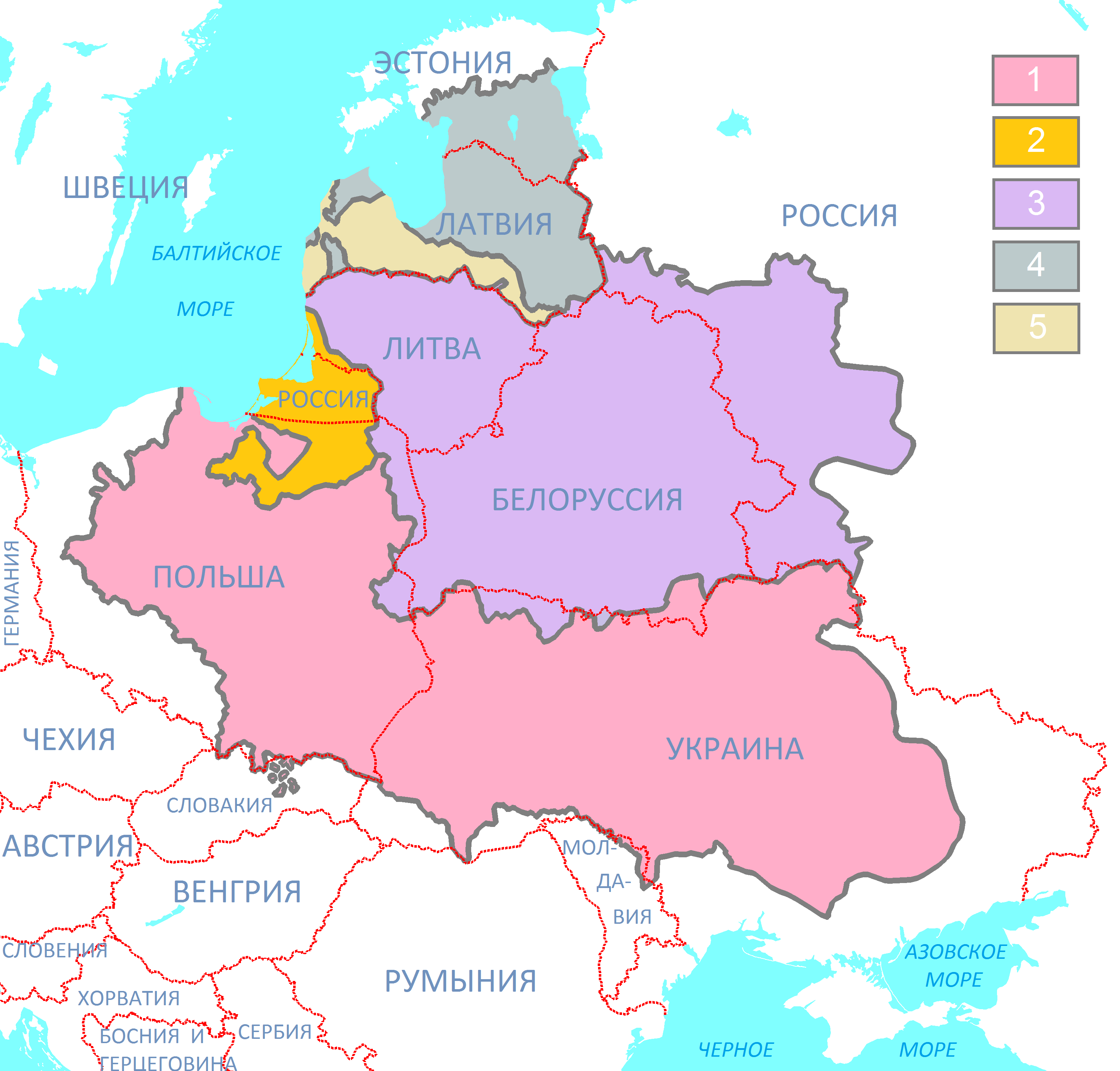
Русский: Речь Посполитая в границах 1619 года в сравнении с границами современных государств (русские подписи)
Легенда: 1 - Королевство Польское (Корона), 2 - Герцогство Пруссия - вассал Короны, 3 - Великое княжество Литовское, 4 -Задвинское герцогство, кондоминиум Литвы и Короны, 5 - Герцогство Курляндия и Семигалия, вассал Литвы, а с 1569 года — Речи ПосполитойБългарски: Жечпосполита в границите от 1619 г. в сравнение с границите на съвременните държави (легенда на български език)
Легенда: 1 - Кралство Полша (Короната), 2 - Херцогство Прусия - васал на Короната, 3 - Велико литовско княжество, 4 - Херцогство Ливония, кондоминиум (съвместно владение) на Литва и Полша, 5 - Херцогство Курландия и Семигалия, васал на Литва, а от 1569 г. — на ЖечпосполитаPolski: Reczpospolita Obojga Narodów (1619) w porównaniu z aktualnymi granicami krajów (napisy rosyjskie)
Legenda mapy: 1 - Korona, 2 - Prusy - Lenno Królestwa Polskiego, 3 - Wielkie Księstwo Litewskie, 4 - Liwlandia - posiadłość Korony i Litwy, 5 - Kurlandia - Lenno RzeczypospolitejEnglish: Polish-Lithuanian Commonwealth (1619) compared with today's borders (Polish names)
Legend: 1 - The Crown (Kingdom of Poland), 2 - Duchy of Prussia - Polish fief, 3 - Grand Duchy of Lithuania, 4 - Livonia, 5 - Duchy of Courland - Livonian fief. |
| Date | |
| Source | Own work |
| Author | Bogomolov.PL |
| Other versions |
|
_compared_with_today%27s_borders_PL.png)
_compared_with_today%27s_borders_(noname).png)
_compared_with_today%27s_borders_(ENG).png)
_compared_with_today%27s_borders,_Ukrainian_version.png)
_compared_with_today%27s_borders_FR.png)
Licensing
[edit]_compared_with_today%27s_borders_(Russian_version).png&action=edit§ion=2)
- You are free:
- to share – to copy, distribute and transmit the work
- to remix – to adapt the work
- Under the following conditions:
- attribution – You must give appropriate credit, provide a link to the license, and indicate if changes were made. You may do so in any reasonable manner, but not in any way that suggests the licensor endorses you or your use.
- share alike – If you remix, transform, or build upon the material, you must distribute your contributions under the same or compatible license as the original.
File history
Click on a date/time to view the file as it appeared at that time.
| Date/Time | Thumbnail | Dimensions | User | Comment | |
|---|---|---|---|---|---|
| current | 16:39, 12 January 2017 | | 3,133 × 2,997 (296 KB) | Bogomolov.PL (talk | contribs) | Kaliningrag region naming |
| 19:48, 26 February 2016 |  | 3,133 × 2,997 (293 KB) | Bogomolov.PL (talk | contribs) | User created page with UploadWizard |
You cannot overwrite this file.
File usage on Commons
There are no pages that use this file.
File usage on other wikis
The following other wikis use this file:
- Usage on ba.wikipedia.org
- Usage on bg.wikipedia.org
- Usage on hy.wikipedia.org
- Usage on ru.wikipedia.org
- Usage on uk.wikipedia.org
- Usage on uz.wikipedia.org
_compared_with_today%27s_borders_(Russian_version).png&oldid=857740930)