File:Plattegrond van Londen na de grote brand van 1666 A Map or Groundplot of the Citty of London and the Suburbes (titel op object), RP-P-OB-82.347.jpg
Jump to navigation
Jump to search

Size of this preview: 680 × 599 pixels. Other resolutions: 272 × 240 pixels | 545 × 480 pixels | 871 × 768 pixels | 1,162 × 1,024 pixels | 2,324 × 2,048 pixels | 4,890 × 4,310 pixels.
Original file (4,890 × 4,310 pixels, file size: 5.84 MB, MIME type: image/jpeg)
Captions
Captions
Add a one-line explanation of what this file represents
Summary
[edit],_RP-P-OB-82.347.jpg&action=edit§ion=1)
| Description |
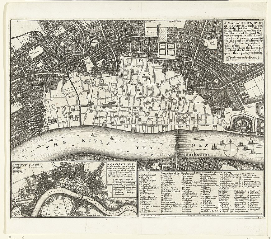
Nederlands: Identificatie Titel(s): Plattegrond van Londen na de grote brand van 1666. A Map or Groundplot of the Citty of London and the Suburbes (...) (titel op object) Objecttype: prent nieuwsprent Objectnummer: RP-P-OB-82.347 Catalogusreferentie: FMH 2249-BPennington 1004-b Omschrijving: Plattegrond van Londen waarop is aangegeven het deel van de stad dat verwoest is tijdens de grote brand van 12-15 september 1666. Linksonder een inzet met een kaart van de gehele stad. Rechtsonder de legenda's 1-100 en A-o. Vervaardiging Vervaardiger: prentmaker: Wenceslaus Hollar (vermeld op object), uitgever: John Overton (vermeld op object) Plaats vervaardiging: prentmaker: Noordelijke Nederlanden, uitgever: Londen Datering: 1666 Fysieke kenmerken: ets Materiaal: papier Techniek: etsen Afmetingen: plaatrand: h 275 mm × b 352 mm Onderwerp Wat: maps of cities. Grote brand van Londen (1666) Wanneer: 1666-09-02 - 1666-09-05. Waar. Londen Verwerving en rechten Verwerving: aankoop 1881 Copyright: Publiek domein |
| Date | |
| Source | http://hdl.handle.net/10934/RM0001.COLLECT.466372 |
| Author | Rijksmuseum |
Licensing
[edit],_RP-P-OB-82.347.jpg&action=edit§ion=2)
| This file is made available under the Creative Commons CC0 1.0 Universal Public Domain Dedication. | |
| The person who associated a work with this deed has dedicated the work to the public domain by waiving all of their rights to the work worldwide under copyright law, including all related and neighboring rights, to the extent allowed by law. You can copy, modify, distribute and perform the work, even for commercial purposes, all without asking permission.
|
File history
Click on a date/time to view the file as it appeared at that time.
| Date/Time | Thumbnail | Dimensions | User | Comment | |
|---|---|---|---|---|---|
| current | 20:13, 16 January 2020 | | 4,890 × 4,310 (5.84 MB) | Mr.Nostalgic (talk | contribs) | == {{int:filedesc}} == {{Information |Description={{nl|1=<br><br><big>'''Identificatie'''</big><br>'''Titel(s): '''Plattegrond van Londen na de grote brand van 1666A Map or Groundplot of the Citty of London and the Suburbes (...) (titel op object)<br>'''Objecttype:''' prent nieuwsprent <br>'''Objectnummer:''' RP-P-OB-82.347<br>'''Catalogusreferentie:''' FMH 2249-BPennington 1004-b<br>'''Omschrijving:''' Plattegrond van Londen <br>'''Waar:''' op is aangegeven het deel van de stad dat verwoest... |
You cannot overwrite this file.
File usage on Commons
There are no pages that use this file.
,_RP-P-OB-82.347.jpg&oldid=850824630)