File:Plat book of Washington and Ozaukee counties, Wisconsin - compiled from county records and actual surveys LOC 2011594849-3.tif
Jump to navigation
Jump to search

Size of this JPG preview of this TIF file: 467 × 599 pixels. Other resolutions: 187 × 240 pixels | 374 × 480 pixels | 599 × 768 pixels | 799 × 1,024 pixels | 1,597 × 2,048 pixels | 4,282 × 5,490 pixels.
Original file (4,282 × 5,490 pixels, file size: 67.26 MB, MIME type: image/tiff)
Captions
Captions
Add a one-line explanation of what this file represents
Summary
[edit]| Description |
English: Includes outline map of the counties and patrons' directory. Available also through the Library of Congress Web site as a raster image. |
||
| Title | Plat book of Washington and Ozaukee counties, Wisconsin : compiled from county records and actual surveys | ||
| Shelf ID | G1418.W4 N6 1915 | ||
| Parent | https://www.loc.gov/resource/g4123wm.gla00199/ | ||
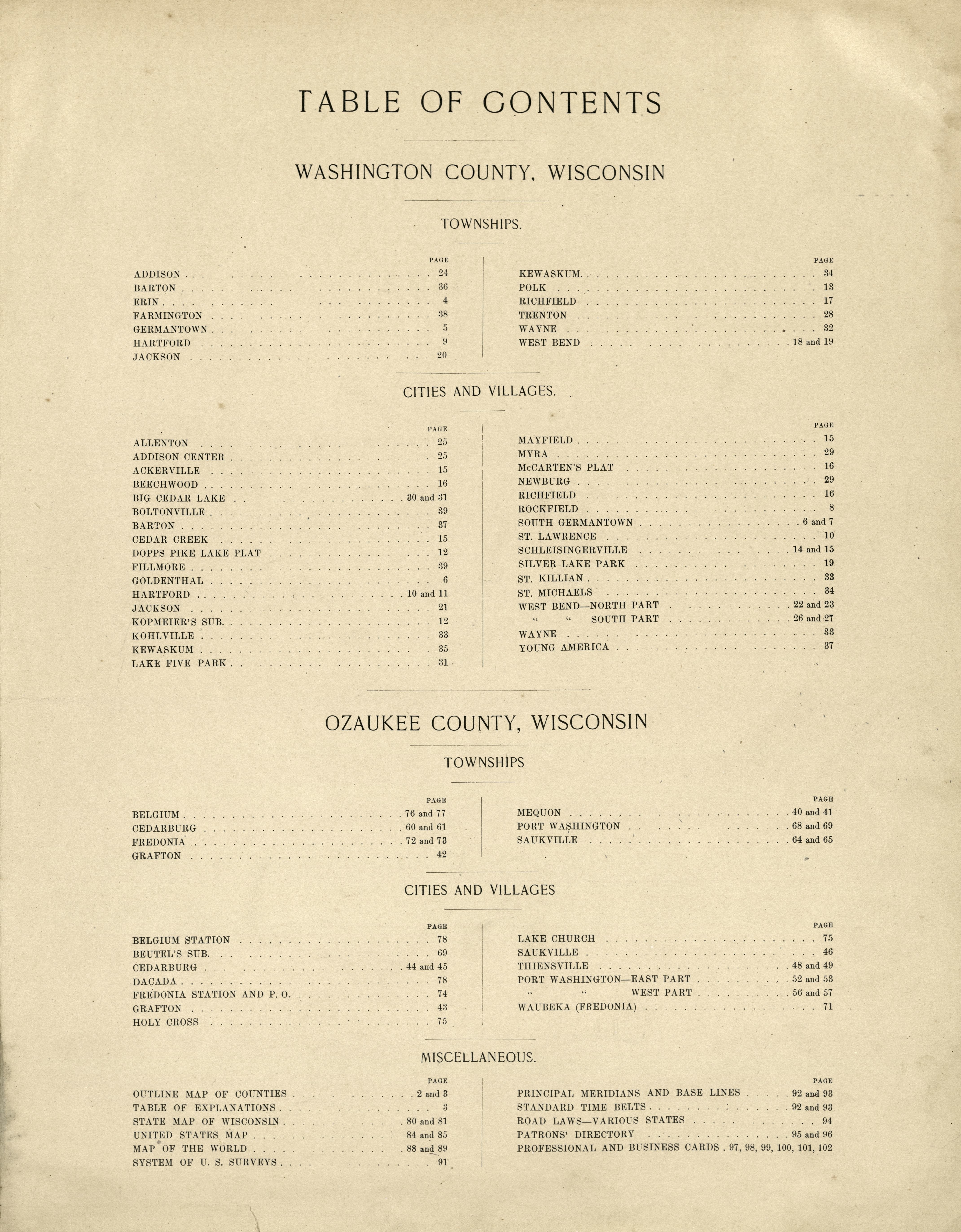
| Sheet title | Table of Contents | ||
| Date | |||
| Source | https://www.loc.gov/item/2011594849/ | ||
| Author | North West Publishing Co.; Volk, Albert | ||
| Permission (Reusing this file) |
|
||
| Other versions |
|
||
| Location | United States · Wisconsin · Washington County · Ozaukee County | ||
| Part of | American Memory · Catalog · County Landownership Maps · Geography And Map Division · Cultural Landscapes | ||
| Subject | Cadastral Maps · Atlases · Wisconsin · Ozaukee County · Washington County · Landowners · United States · Maps · Real Property · Washington County (Wis.) · Ozaukee County (Wis.) |


Licensing
[edit]|
This is a faithful photographic reproduction of a two-dimensional, public domain work of art. The work of art itself is in the public domain for the following reason:
The official position taken by the Wikimedia Foundation is that "faithful reproductions of two-dimensional public domain works of art are public domain".
This photographic reproduction is therefore also considered to be in the public domain in the United States. In other jurisdictions, re-use of this content may be restricted; see Reuse of PD-Art photographs for details. | ||||
File history
Click on a date/time to view the file as it appeared at that time.
| Date/Time | Thumbnail | Dimensions | User | Comment | |
|---|---|---|---|---|---|
| current | 06:43, 9 June 2018 |  | 4,282 × 5,490 (67.26 MB) | Fæ (talk | contribs) | LOC Maps multisheet https://www.loc.gov/item/2011594849/ sheet 3 of 64 #14596 |
You cannot overwrite this file.
File usage on Commons
The following page uses this file: