File:Plan of the Baton Rouge as it as been formerly built (fbar) the 20th 1813 LOC 2012588002.tif
Jump to navigation
Jump to search

Size of this JPG preview of this TIF file: 363 × 600 pixels. Other resolutions: 145 × 240 pixels | 290 × 480 pixels | 465 × 768 pixels | 620 × 1,024 pixels | 1,240 × 2,048 pixels | 2,574 × 4,251 pixels.
Original file (2,574 × 4,251 pixels, file size: 31.31 MB, MIME type: image/tiff)
Captions
Captions
Add a one-line explanation of what this file represents
Summary
[edit]| Description |
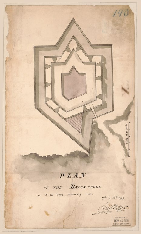
English: Relief shown pictorially. Pen-and-ink, pencil, and watercolor. "Office of Chief of Engineers, War Department. 58510 467" on verso. Minimal level cataloging record. Available also through the Library of Congress Web site as a raster image. |
||
| Title | Plan of the Baton Rouge as it as been formerly built [fbar] the 20th 1813 | ||
| Shelf ID | G4014.B3 1813 .L3 | ||
| Date | |||
| Source | https://www.loc.gov/item/2012588002/ | ||
| Author | United States. War Department. Office Of The Chief Of Engineers; Lafon, Barthélémy | ||
| Permission (Reusing this file) |
|
||
| Other versions |
|
||
| Location | United States · Baton Rouge. · Baton Rouge · Louisiana · Lousiana | ||
| Part of | Military Battles And Campaigns · Cities And Towns · Catalog · Geography And Map Division · American Memory | ||
| Subject | Baton Rouge · United States · Maps · Baton Rouge (La.) · Louisiana · Manuscript Maps |

_the_20th_1813_LOC_2012588002.jpg)
Licensing
[edit]|
This is a faithful photographic reproduction of a two-dimensional, public domain work of art. The work of art itself is in the public domain for the following reason:
The official position taken by the Wikimedia Foundation is that "faithful reproductions of two-dimensional public domain works of art are public domain".
This photographic reproduction is therefore also considered to be in the public domain in the United States. In other jurisdictions, re-use of this content may be restricted; see Reuse of PD-Art photographs for details. | ||||
File history
Click on a date/time to view the file as it appeared at that time.
| Date/Time | Thumbnail | Dimensions | User | Comment | |
|---|---|---|---|---|---|
| current | 18:08, 7 November 2019 |  | 2,574 × 4,251 (31.31 MB) | Fæ (talk | contribs) | LOC Maps https://www.loc.gov/item/2012588002/ #18370 |
You cannot overwrite this file.
File usage on Commons
The following page uses this file: