File:Pit River Canyon WSA (9472751188).jpg
Jump to navigation
Jump to search
Size of this preview: 800 × 533 pixels. Other resolutions: 320 × 213 pixels | 640 × 427 pixels | 1,024 × 682 pixels | 1,280 × 853 pixels | 2,560 × 1,706 pixels | 5,615 × 3,742 pixels.
Original file (5,615 × 3,742 pixels, file size: 22.35 MB, MIME type: image/jpeg)
Captions
Captions
Add a one-line explanation of what this file represents
Summary
[edit].jpg&action=edit§ion=1)
| Description |
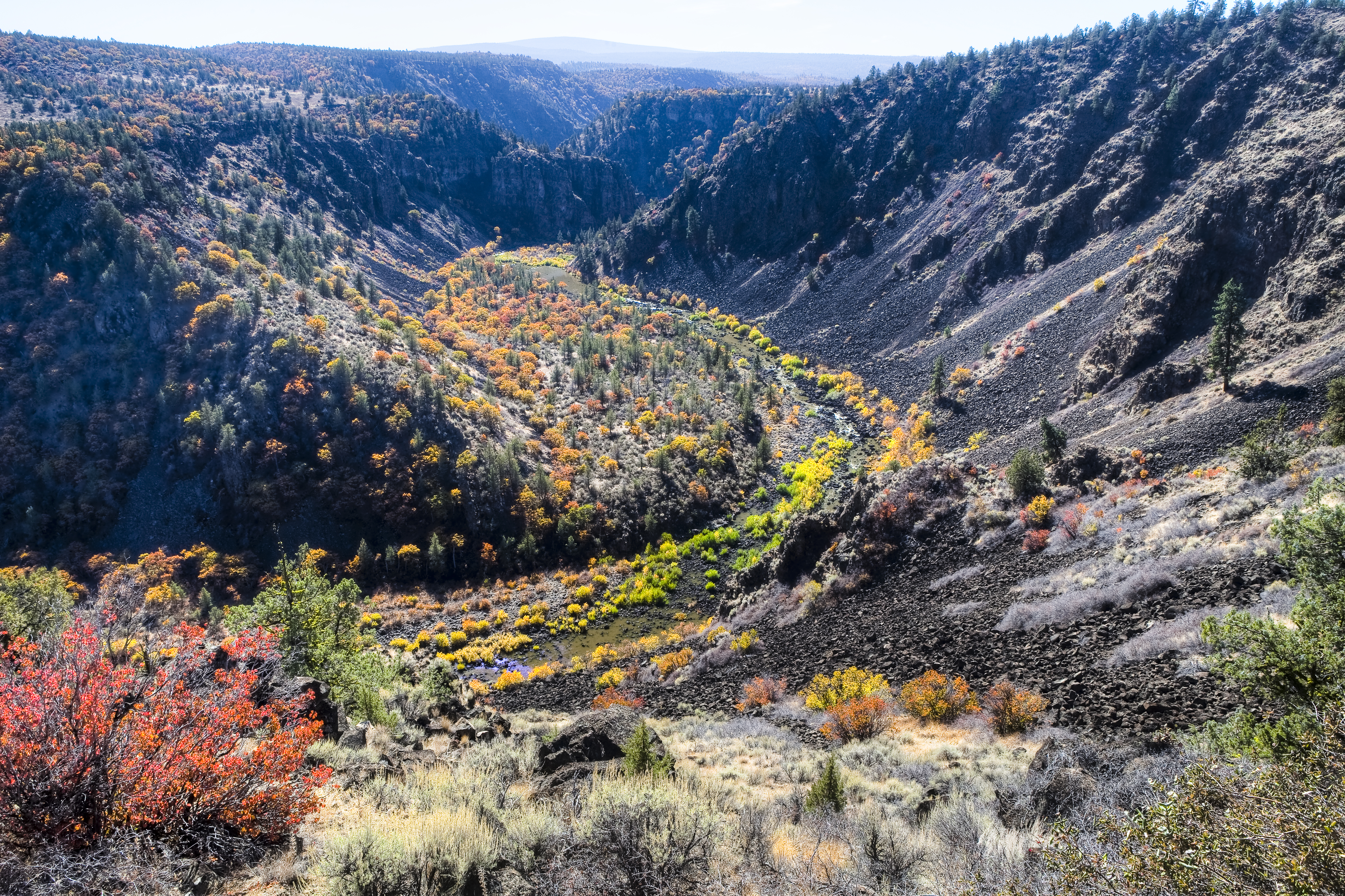
English: The Pit River Canyon Wilderness Study Area is comprised of 10,984 acres (4,445 ha) and has outstanding opportunities for solitude or primitive types of unconfined recreation. There are 13 miles (21 km) of the Pit River within the WSA with dynamic geology, wildlife, and historic values. The flats above the canyon have yearlong populations of deer and antelope, while birds of prey utilize the canyon resources. Segments of the 1848 National Historic Lassen Emigrant Trail is located within the boundary of the WSA. Legal access is limited due to intermingled private and public lands, always secure permission prior to entry.
Learn more: www.flickr.com/photos/mypubliclands/sets/72157634998468606/ Photo: Bob Wick, BLM California |
| Date | |
| Source | Pit River Canyon WSA |
| Author | Bob Wick; Bureau of Land Management |
Licensing
[edit].jpg&action=edit§ion=2)
This file is licensed under the Creative Commons Attribution 2.0 Generic license.
- You are free:
- to share – to copy, distribute and transmit the work
- to remix – to adapt the work
- Under the following conditions:
- attribution – You must give appropriate credit, provide a link to the license, and indicate if changes were made. You may do so in any reasonable manner, but not in any way that suggests the licensor endorses you or your use.
| This image was originally posted to Flickr by mypubliclands at https://flickr.com/photos/91981596@N06/9472751188. It was reviewed on 5 August 2015 by FlickreviewR and was confirmed to be licensed under the terms of the cc-by-2.0. |
| This image is a work of a Bureau of Land Management* employee, taken or made as part of that person's official duties. As a work of the U.S. federal government, the image is in the public domain in the United States. *or predecessor organization |
File history
Click on a date/time to view the file as it appeared at that time.
| Date/Time | Thumbnail | Dimensions | User | Comment | |
|---|---|---|---|---|---|
| current | 20:02, 4 August 2015 | | 5,615 × 3,742 (22.35 MB) | Wilfredor (talk | contribs) | Transferred from Flickr via Flickr2Commons |
You cannot overwrite this file.
File usage on Commons
There are no pages that use this file.
File usage on other wikis
The following other wikis use this file:
- Usage on en.wikipedia.org
- Usage on he.wikipedia.org
.jpg&oldid=629383143)