Category:Photographs by Bob Wick
Jump to navigation
Jump to search
Bob Wick is a prolific outdoor photographer for the US Bureau of Land Management. All of his photos that are taken in his professional capacity as a BLM employee, are free of all copyright restrictions as works of the US government.
Media in category "Photographs by Bob Wick"
The following 200 files are in this category, out of 491 total.
(previous page) (next page)-

-

-

-
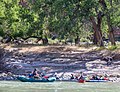
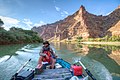
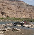
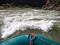
 A group taking rafts down the Green River in Utah's Desolation Canyon Area.jpg 2,500 × 1,667; 782 KB
-
 A moose near the Steese Highway in Alaska.jpg 2,048 × 1,365; 1.56 MB
-
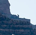
 A mountain goat found in Utah's Desolation Canyon Area - 49064477253.jpg 1,961 × 1,550; 1.48 MB
-
 A mountain goat found in Utah's Desolation Canyon Area.jpg 1,117 × 1,173; 745 KB
-
 A mountain peak in Utah's Desolation Canyon Area.jpg 1,427 × 1,387; 480 KB
-
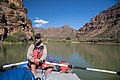
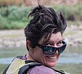
 A park ranger stops to take in the beauty of Utah's Desolation Canyon Area.jpg 2,500 × 1,663; 2.27 MB
-

-
-
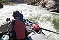
 A park ranger surveying Utah's Desolation Canyon Area by raft in the Green River.jpg 2,500 × 1,667; 1.26 MB
-
 A park ranger surveys Utah's Desolation Canyon Area - 49059877597.jpg 2,500 × 1,667; 897 KB
-

-

-
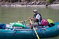
 A park ranger surveys Utah's Desolation Canyon Area by raft in the Green River.jpg 1,909 × 2,500; 1.78 MB
-
 A park ranger surveys Utah's Desolation Canyon Area.jpg 2,500 × 1,667; 1.24 MB
-
 A park ranger white water rafts down the Green River of Utah's Desolation Canyon Area.jpg 2,500 × 1,918; 1.37 MB
-

-

-

-
 A park ranger whitewater rafting in the Green River of Utah's Desolation Canyon Area.jpg 2,500 × 2,204; 2.06 MB
-
 A petroglyph in Utah's Desolation Canyon Area.jpg 2,500 × 2,180; 1.94 MB
-
 A shallow point of the Green River within Utah's Desolation Canyon Area - 49059140903.jpg 2,500 × 1,662; 2.06 MB
-
 A shallow point of the Green River within Utah's Desolation Canyon Area - 49059141408.jpg 1,667 × 2,500; 2.39 MB
-
 A shallow point of the Green River within Utah's Desolation Canyon Area.jpg 1,664 × 2,500; 1.88 MB
-
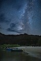
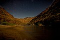 A starry night in Utah's Desolation Canyon Area.jpg 2,500 × 1,667; 1.14 MB
-
 A visitor takes in the beauty of their -PublicLand at Utah's Desolation Canyon Area.jpg 1,667 × 2,500; 891 KB
-
 Adventurers go kayaking in the Green River of Utah's Desolation Canyon Area.jpg 2,500 × 1,759; 2.04 MB
-
 Adventurers greeting one another in Utah's Desolation Canyon Area.jpg 2,500 × 1,845; 1.66 MB
-
 Adventurers pausing along the Green River to talk - 49065003721.jpg 1,664 × 2,500; 1.92 MB
-
 Adventurers pausing along the Green River to talk.jpg 2,500 × 1,908; 2.38 MB
-
 Amargosa Wild and Scenic River, California.jpg 4,000 × 2,156; 5.64 MB
-
 Amboy Crater Area of Critical Environmental Concern, California (15039266973).jpg 3,000 × 2,000; 1.97 MB
-
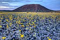 Amboy Crater of Mojave Trails National Monument.jpg 2,500 × 1,667; 2.6 MB
-
 An abandoned cabin in Utah's beautiful Desolation Canyon Area.jpg 2,500 × 1,667; 2 MB
-
 An abandoned cabin Utah's Desolation Canyon Area.jpg 2,500 × 1,666; 2.38 MB
-
 An animal track found in Utah's Desolation Canyon Area.jpg 2,500 × 1,667; 1.62 MB
-
 An excited BLM park ranger in a Utah's Desolation Canyon Area.jpg 2,500 × 2,258; 846 KB
-
 An explorer navigates the Green River within Utah's Desolation Canyon Area.jpg 2,500 × 1,666; 1.31 MB
-
 An explorer paddle boarding down the Green River in Utah's Desolation Canyon Area.jpg 2,500 × 1,963; 1.74 MB
-
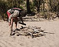 An explorer prepares a campfire in Utah's Desolation Canyon Area.jpg 2,500 × 2,006; 1.64 MB
-
 An explorer rafts down the Green River for a survey of Utah's Desolation Canyon Area.jpg 2,500 × 1,307; 1.29 MB
-
 An group discusses their exploration of Utah's Desolation Canyon Area.jpg 2,500 × 1,869; 2.22 MB
-
 An interesting rock formation in Utah's Desolation Canyon Area - 49059876372.jpg 2,500 × 1,667; 781 KB
-
 An interesting rock formation in Utah's Desolation Canyon Area.jpg 2,500 × 1,947; 1.97 MB
-

-
 Basin and Range National Monument (21599283392).jpg 2,878 × 883; 309 KB
-
 Bear Trap Canyon Wilderness (15101523246).jpg 4,320 × 2,880; 5.95 MB
-
 Beauty can be found all over as stars rest above Utah's Desolation Canyon Area.jpg 1,667 × 2,500; 1.19 MB
-
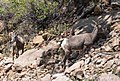 Bighorn sheep found in Utah's Desolation Canyon Area.jpg 2,210 × 1,496; 1.51 MB
-
 BLM employees survey the Green River in Utah's Desolation Canyon Area.jpg 2,500 × 1,667; 1.7 MB
-
 BLM Kern River OF visit.jpg 2,048 × 1,365; 271 KB
-
 BLM park rangers survey Utah's Desolation Canyon Area by rafts in the Green River.jpg 2,500 × 1,667; 1.35 MB
-
 BLM park rangers survey Utah's Desolation Canyon Area.jpg 1,957 × 2,021; 1.57 MB
-
 BLM park rangers white water raft down the Green River in Utah's Desolation Canyon Area.jpg 2,500 × 2,117; 1.63 MB
-

-
 Bonneville Salt Flats (17235453660).jpg 2,500 × 1,663; 2.43 MB
-
 Bruneau Canyon Overlook ID.jpg 1,800 × 1,200; 1.48 MB
-
 Burning Man 2012 (9301535228).jpg 5,616 × 3,744; 10.13 MB
-
 Burning Man 2012 (9301536830).jpg 5,616 × 3,744; 9.73 MB
-

-
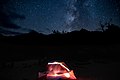 Campers enjoy a starry night in Utah's Desolation Canyon Area.jpg 2,500 × 1,667; 626 KB
-
 Canoes parked on the shore of the Green Rivier in Utah's Desolation Canyon Area.jpg 2,500 × 1,667; 1.81 MB
-
 Carnegiea gigantea - Ragged top, late afternoon.jpg 1,280 × 853; 522 KB
-
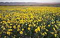 Carrizo Plains wildflowers BLM.jpg 1,200 × 766; 322 KB
-
 Case mountain sequoias.jpg 1,200 × 799; 520 KB
-
 Closeup of a petroglyph in Utah's Desolation Canyon Area.jpg 2,500 × 1,667; 1.78 MB
-
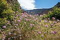 Colorful plant wildlife within Utah's Desolation Canyon Area.jpg 2,500 × 1,667; 2.37 MB
-
 Conway Summit ACEC (15783485442).jpg 2,000 × 1,333; 1.45 MB
-
 Conway Summit Area of Critical Environmental Concern (26388457754).jpg 5,000 × 3,049; 13.88 MB
-
 Conway Summit Area of Critical Environmental Concern (26720461500).jpg 5,000 × 3,088; 14.04 MB
-
 Conway Summit Area of Critical Environmental Concern (26720464820).jpg 5,000 × 3,333; 15.72 MB
-
 Conway Summit Area of Critical Environmental Concern (26720470420).jpg 5,000 × 2,648; 10.08 MB
-
 Conway Summit Area of Critical Environmental Concern (26720484280).jpg 5,000 × 3,333; 14.71 MB
-
 Conway Summit Area of Critical Environmental Concern (28173157674).jpg 5,000 × 3,398; 14.47 MB
-
 Conway Summit Area of Critical Environmental Concern (28173168224).jpg 5,000 × 3,334; 15.14 MB
-
 Conway Summit Area of Critical Environmental Concern (28175914533).jpg 5,000 × 3,333; 15.88 MB
-
 Conway Summit Area of Critical Environmental Concern (28175921173).jpg 5,000 × 3,331; 19.67 MB
-
 Conway Summit Area of Critical Environmental Concern (28713605451).jpg 5,000 × 3,464; 19 MB
-
 Conway Summit Area of Critical Environmental Concern (28713681441).jpg 5,000 × 2,798; 14.78 MB
-
 Conway Summit Area of Critical Environmental Concern (28758954756).jpg 5,000 × 3,335; 15.92 MB
-
 Conway Summit Area of Critical Environmental Concern (28790863995).jpg 5,000 × 3,333; 16.8 MB
-
 Conway Summit Area of Critical Environmental Concern (28790868865).jpg 4,942 × 3,358; 16.72 MB
-
 Conway Summit Area of Critical Environmental Concern (28790884085).jpg 5,000 × 3,332; 14.46 MB
-
 Desert Lily Preserve Calif.jpg 2,000 × 1,333; 1.2 MB
-
 Dos Palmas Preserve Area of Critical Environmental Concern, California (15473839010).jpg 3,000 × 2,000; 3.46 MB
-
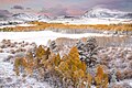
 Early winter in the Bodie Hills 2017.jpg 2,048 × 1,365; 717 KB
-
 Elephant seals off the Piedras Blancas Light Station.jpg 2,000 × 1,589; 1.14 MB
-
 Excited explorers survey Utah's Desolation Canyon Area by raft in the Green River.jpg 2,500 × 2,230; 1.46 MB
-
 Explorers before white water rafting in the Green River in Utah's Desolation Canyon Area.jpg 2,500 × 1,667; 1.47 MB
-
 Explorers coast down the Green River of Utah's Desolation Canyon Area in a raft.jpg 2,500 × 1,667; 1.07 MB
-
 Explorers enjoy a meal along the shore of the Green River.jpg 2,500 × 1,666; 1.41 MB
-

-

-
 Explorers excitedly raft down the Green River of Utah's Desolation Canyon Area in a raft.jpg 2,500 × 2,441; 2.04 MB
-

-

-
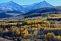
 Fall Colors at Conway Summit ACEC (22339963870).jpg 2,000 × 1,333; 1.97 MB
-
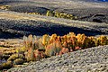
 Fall Colors at Conway Summit ACEC (22514408012).jpg 2,000 × 1,333; 2.14 MB
-
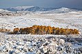
 Fall Colors at Conway Summit ACEC (22539049231).jpg 2,000 × 1,359; 2.06 MB
-
-
 Goosenecks of the San Juan.JPG 1,280 × 853; 433 KB
-
 Granite Mtns Wilderness CA.JPG 2,048 × 1,365; 552 KB
-
 Gulkana WSR (16518744187).jpg 2,172 × 1,467; 2.41 MB
-
 Gulkana WSR (16518752727).jpg 2,528 × 1,828; 4.22 MB
-
 Gulkana WSR (16538585230).jpg 4,149 × 2,880; 11.62 MB
-
 Gulkana WSR (16539862509).jpg 5,760 × 3,840; 17.54 MB
-
 Gulkana WSR (16724768951).jpg 4,485 × 3,033; 11.38 MB
-
 Gulkana WSR (16726023675).jpg 2,639 × 1,851; 3.49 MB
-
 Gunnison Gorge NCA (9312490805).jpg 5,616 × 3,744; 11.43 MB
-
 Gunnison Gorge NCA (9312540675).jpg 696 × 900; 263 KB
-
 Gunnison Gorge NCA (9315277050).jpg 600 × 600; 180 KB
-
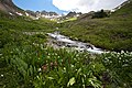
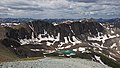
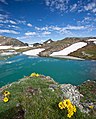
 Handies Peak WSA (9463623979).jpg 3,627 × 5,441; 16.56 MB
-
 Handies Peak WSA (9463628589).jpg 5,458 × 3,639; 11.64 MB
-
 Handies Peak WSA (9463660293).jpg 5,455 × 3,637; 14.23 MB
-
 Handies Peak WSA (9463680689).jpg 5,616 × 3,744; 21.43 MB
-
 Handies Peak WSA (9464539331).jpg 5,465 × 3,644; 16.21 MB
-
 Handies Peak WSA (9464548897).jpg 5,616 × 3,744; 13.78 MB
-
 Handies Peak WSA (9464669595).jpg 1,903 × 2,537; 4.33 MB
-
 Handies Peak WSA (9464673273).jpg 5,261 × 3,508; 12.35 MB
-
 Handies Peak WSA (9464712075).jpg 5,616 × 3,744; 20.38 MB
-
 Handies Peak WSA (9464724043).jpg 5,616 × 3,744; 18.39 MB
-
 Handies Peak WSA (9464742003).jpg 5,616 × 3,744; 15.9 MB
-
 Handies Peak WSA (9464749973).jpg 5,396 × 3,597; 12.09 MB
-
 Handies Peak WSA (9464774561).jpg 1,857 × 2,766; 3.91 MB
-
 Handies Peak WSA (9464783797).jpg 5,616 × 3,744; 18.31 MB
-
 Handies Peak WSA (9464788527).jpg 5,616 × 3,194; 13.74 MB
-
 Handies Peak WSA (9464856907).jpg 3,675 × 4,569; 12.35 MB
-
 Handies Peak WSA (9464874829).jpg 2,682 × 1,788; 4.7 MB
-
 Handies Peak WSA (9464909639).jpg 30,348 × 2,733; 54.83 MB
-
 Handies Peak WSA (9464918585).jpg 8,222 × 4,103; 25.78 MB
-
 Handies Peak WSA (9466398654).jpg 3,614 × 4,595; 10.85 MB
-
 Handies Peak WSA (9466416818).jpg 3,744 × 5,616; 16.97 MB
-
 Handies Peak WSA (9466436592).jpg 5,616 × 3,744; 21.56 MB
-
 Handies Peak WSA (9466467484).jpg 3,744 × 5,616; 16.67 MB
-
 Handies Peak WSA (9466489152).jpg 5,616 × 3,744; 24.38 MB
-
 Handies Peak WSA (9466493664).jpg 3,512 × 5,269; 13.53 MB
-
 Handies Peak WSA (9467287034).jpg 5,462 × 3,642; 15.57 MB
-
 Handies Peak WSA (9467291524).jpg 5,309 × 3,540; 12.67 MB
-
 Handies Peak WSA (9467297146).jpg 5,397 × 3,597; 14.24 MB
-
 Handies Peak WSA (9467311276).jpg 5,616 × 3,744; 13.92 MB
-
 Handies Peak WSA (9467315880).jpg 5,616 × 3,744; 13.49 MB
-
 Handies Peak WSA (9467334860).jpg 3,744 × 5,616; 13.49 MB
-
 Handies Peak WSA (9467339830).jpg 3,744 × 5,616; 16.21 MB
-
 Handies Peak WSA (9467450220).jpg 1,903 × 1,375; 2.38 MB
-
 Handies Peak WSA (9467472864).jpg 5,616 × 3,744; 17.27 MB
-
 Handies Peak WSA (9467479288).jpg 5,454 × 3,636; 18.44 MB
-
 Handies Peak WSA (9467498910).jpg 3,744 × 5,616; 16.51 MB
-
 Handies Peak WSA (9467518106).jpg 5,616 × 3,744; 19.18 MB
-
 Handies Peak WSA (9467554118).jpg 5,616 × 3,744; 17.99 MB
-
 Handies Peak WSA (9467591186).jpg 5,616 × 3,744; 22.04 MB
-
 Handies Peak WSA (9467617540).jpg 5,616 × 3,744; 17.4 MB
-
 Handies Peak WSA (9467628580).jpg 3,744 × 5,203; 17.53 MB
-
 Handies Peak WSA (9467643698).jpg 5,616 × 3,744; 17.03 MB
-
 Handies Peak WSA (9467649390).jpg 5,552 × 3,701; 16.26 MB
-
 Handies Peak WSA (9467653982).jpg 5,460 × 3,640; 13.33 MB
-
 Handies Peak WSA (9467656492).jpg 2,070 × 1,383; 2.56 MB
-
 Handies Peak WSA (9467671426).jpg 3,744 × 5,616; 20.14 MB
-
 Harbor Seal from California Coastal National Monument.jpg 2,400 × 1,532; 2.27 MB
-
 Humbug Spires WSA (9466935079).jpg 4,320 × 2,880; 6.54 MB
-
 Humbug Spires WSA (9466936503).jpg 4,320 × 2,880; 7.67 MB
-
 Humbug Spires WSA (9466938901).jpg 4,320 × 2,878; 9.08 MB
-
 Humbug Spires WSA (9466941077).jpg 4,320 × 2,880; 7.95 MB
-
 Humbug Spires WSA (9466943365).jpg 4,320 × 2,880; 8.79 MB
-
 Humbug Spires WSA (9466956845).jpg 4,320 × 2,880; 9.14 MB
-
 Humbug Spires WSA (9466963719).jpg 4,320 × 2,880; 9.05 MB
-
 Humbug Spires WSA (9466983337).jpg 2,880 × 4,320; 6.5 MB
-
 Humbug Spires WSA (9466995405).jpg 2,880 × 4,320; 7.61 MB
-
 Humbug Spires WSA (9466997827).jpg 2,880 × 4,320; 8.69 MB
-
 Humbug Spires WSA (9467002835).jpg 2,880 × 4,320; 8.48 MB
-
 Humbug Spires WSA (9467006269).jpg 4,320 × 2,880; 7 MB
-
 Humbug Spires WSA (9469734210).jpg 4,320 × 2,880; 8.5 MB
-
 Humbug Spires WSA (9469748704).jpg 2,879 × 4,320; 9.32 MB
-
 Humbug Spires WSA (9469750588).jpg 4,320 × 2,880; 7.33 MB
-
 Humbug Spires WSA (9469752480).jpg 4,320 × 3,177; 6.91 MB
-
 Humbug Spires WSA (9469754514).jpg 4,320 × 2,880; 8.28 MB
-
 Humbug Spires WSA (9469758340).jpg 4,320 × 2,880; 6.13 MB
-
 Humbug Spires WSA (9469760974).jpg 4,320 × 2,879; 9.75 MB
-
 Humbug Spires WSA (9469762444).jpg 2,879 × 4,320; 6.17 MB
-
 Humbug Spires WSA (9469767136).jpg 2,880 × 4,320; 6.26 MB
-
 Humbug Spires WSA (9469768288).jpg 2,788 × 4,320; 4.13 MB
-
 Humbug Spires WSA (9469772576).jpg 2,880 × 4,320; 6.74 MB
-
 Humbug Spires WSA (9469775446).jpg 2,880 × 4,320; 10.16 MB
-
 Humbug Spires WSA (9469782736).jpg 4,320 × 2,880; 9.47 MB
-
 Humbug Spires WSA (9469786764).jpg 4,320 × 2,880; 6.18 MB
-
 Humbug Spires WSA (9469790102).jpg 4,320 × 2,880; 6.06 MB
-
 Humbug Spires WSA (9469792174).jpg 4,320 × 2,895; 8.29 MB
-
 Humbug Spires WSA (9469794570).jpg 4,320 × 3,028; 9.01 MB
-
 Humbug Spires WSA (9469796516).jpg 4,320 × 2,880; 7.3 MB
-
 Humbug Spires WSA (9469798534).jpg 4,320 × 2,880; 7.42 MB
-
 Humbug Spires WSA (9469800228).jpg 4,320 × 2,880; 5.5 MB
-
 Hummingbird Springs Wilderness (9415472166).jpg 5,094 × 3,396; 9.42 MB
-
 Ignacio Chavez WSA (9508970873).jpg 5,616 × 3,744; 16.31 MB
-
 Ignacio Chavez WSA (9511714092).jpg 5,616 × 3,744; 12.45 MB
-
 Ignacio Chavez WSA (9511721480).jpg 5,616 × 3,744; 18.37 MB
-
 Ignacio Chavez WSA (9511757044).jpg 5,616 × 3,744; 18.35 MB
-
 Inyo Mountain Wilderness.jpg 1,024 × 683; 216 KB
-
 Ironwood Forest NM 2.jpg 3,600 × 2,377; 7.17 MB
-
 Ironwood Forest NM 3.jpg 3,600 × 2,400; 4.5 MB
.jpg)
.jpg)
.jpg)


.jpg)


.jpg)
.jpg)


.jpg)
.jpg)

.jpg)
.jpg)


.jpg)
.jpg)
.jpg)
.jpg)
.jpg)
.jpg)
.jpg)
.jpg)
.jpg)
.jpg)
.jpg)
.jpg)
.jpg)
.jpg)
.jpg)
.jpg)

.jpg)


.jpg)
.jpg)
.jpg)


.jpg)
.jpg)
.jpg)
.jpg)
.jpg)
.jpg)
.jpg)
.jpg)
.jpg)
.jpg)
.jpg)
.jpg)
.jpg)
.jpg)
.jpg)
.jpg)
.jpg)
.jpg)
.jpg)
.jpg)
.jpg)
.jpg)
.jpg)
.jpg)
.jpg)
.jpg)
.jpg)
.jpg)
.jpg)
.jpg)
.jpg)
.jpg)
.jpg)
.jpg)
.jpg)
.jpg)
.jpg)
.jpg)
.jpg)
.jpg)
.jpg)
.jpg)
.jpg)
.jpg)
.jpg)
.jpg)
.jpg)
.jpg)
.jpg)
.jpg)
.jpg)
.jpg)
.jpg)
.jpg)

.jpg)
.jpg)
.jpg)
.jpg)
.jpg)
.jpg)
.jpg)
.jpg)
.jpg)
.jpg)
.jpg)
.jpg)
.jpg)
.jpg)
.jpg)
.jpg)
.jpg)
.jpg)
.jpg)
.jpg)
.jpg)
.jpg)
.jpg)
.jpg)
.jpg)
.jpg)
.jpg)
.jpg)
.jpg)
.jpg)
.jpg)
.jpg)
.jpg)
.jpg)
.jpg)
.jpg)
.jpg)


.jpg)
.jpg)