File:Pharus-Plan Berlin ca1919.jpg
Jump to navigation
Jump to search

Size of this preview: 751 × 600 pixels. Other resolutions: 301 × 240 pixels | 601 × 480 pixels | 962 × 768 pixels | 1,280 × 1,022 pixels | 2,560 × 2,044 pixels | 7,704 × 6,152 pixels.
Original file (7,704 × 6,152 pixels, file size: 25.66 MB, MIME type: image/jpeg)
Captions
Captions
Add a one-line explanation of what this file represents
Summary
[edit]
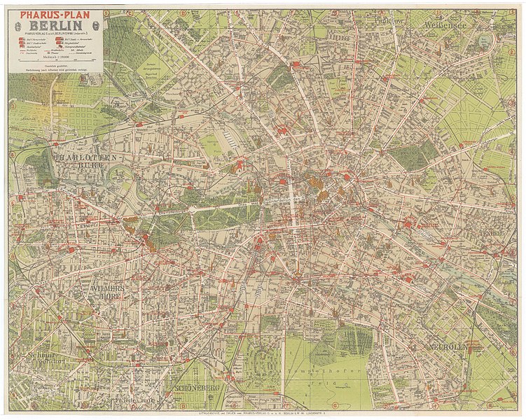
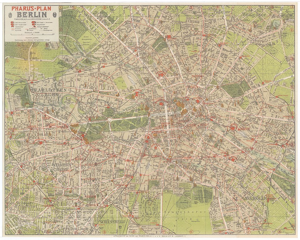
| Title |
Pharus-Plan Berlin |
|||||||||
| Description |
Deutsch: Rechts unten im Plan eine Kennzeichnung "1911". Planinhalt etwa 1916-1919. Kriegsbedingt wohl nur mangalhaft aktualisiert und gedruckt. Die 1916 fertiggestellte Bösebrücke (Hindenburgbrücke) wurde offenbar im Plan nachgetragen. In Wilmersdorf wurde die Hindenburgstraße nachgetragen und die alte Bezeichnung "Seepark" mangelhaft retouschiert. |
|||||||||
| Source | Mapová sbírka PrF UK (Map collection of Charles University) (online) | |||||||||
| Creator |
Dr. Cornelius Löwe (* ?; † 1932/33) |
|||||||||
| Geotemporal data | ||||||||||
| Date depicted | between circa 1916 and circa 1919 | |||||||||
| Map location | Berlin | |||||||||
| Scale | 1:28,000 | |||||||||
| Heading |
 |
|||||||||
| Bounding box |
|
|||||||||
| Georeferencing | ||||||||||
| Bibliographic data | ||||||||||
| Language | German | |||||||||
| Publisher |
Pharus-Verlag |
|||||||||
| Archival data | ||||||||||
| Collection | Univerzita Karlova v Praze, Ústav výpocetní techniky (Charles University in Prague) | |||||||||
| Accession number |
000010739 |
|||||||||
| Dimensions | height: 39 cm (15.3 in); width: 49 cm (19.2 in) | |||||||||
Licensing
[edit]
|
This work is in the public domain in its country of origin and other countries and areas where the copyright term is the author's life plus 70 years or fewer. | |
| This file has been identified as being free of known restrictions under copyright law, including all related and neighboring rights. | |

|
This work includes material that may be protected as a trademark in some jurisdictions. If you want to use it, you have to ensure that you have the legal right to do so and that you do not infringe any trademark rights. See our general disclaimer. This tag does not indicate the copyright status of the attached work. A normal copyright tag is still required. See Commons:Licensing. |
File history
Click on a date/time to view the file as it appeared at that time.
| Date/Time | Thumbnail | Dimensions | User | Comment | |
|---|---|---|---|---|---|
| current | 21:22, 6 January 2016 | | 7,704 × 6,152 (25.66 MB) | Alexrk2 (talk | contribs) | == {{int:description}} == {{InteractiveViewer}} {{Map |title='''Pharus-Plan Berlin''' |description={{de|Rechts unten im Plan eine Kennzeichnung "1911". Planinhalt etwa 1916-1919. Kriegsbedingt wohl nur mangalhaft aktualisiert und gedruckt. Die 1916 fer... |
You cannot overwrite this file.
File usage on Commons
The following page uses this file: