File:Passages of the Rappahannock and Battle of Fredericksburg, December 10th to 16th, 1862 - copied from the original belonging to Gen'l. Burnside LOC lva0000023.jpg
Jump to navigation
Jump to search

Size of this preview: 747 × 599 pixels. Other resolutions: 299 × 240 pixels | 598 × 480 pixels | 957 × 768 pixels | 1,277 × 1,024 pixels | 2,553 × 2,048 pixels | 11,190 × 8,977 pixels.
Original file (11,190 × 8,977 pixels, file size: 23.53 MB, MIME type: image/jpeg)
Captions
Captions
Add a one-line explanation of what this file represents
Summary
[edit]| Warning | The original file is very high-resolution. It might not load properly or could cause your browser to freeze when opened at full size. |
|---|
| Description |
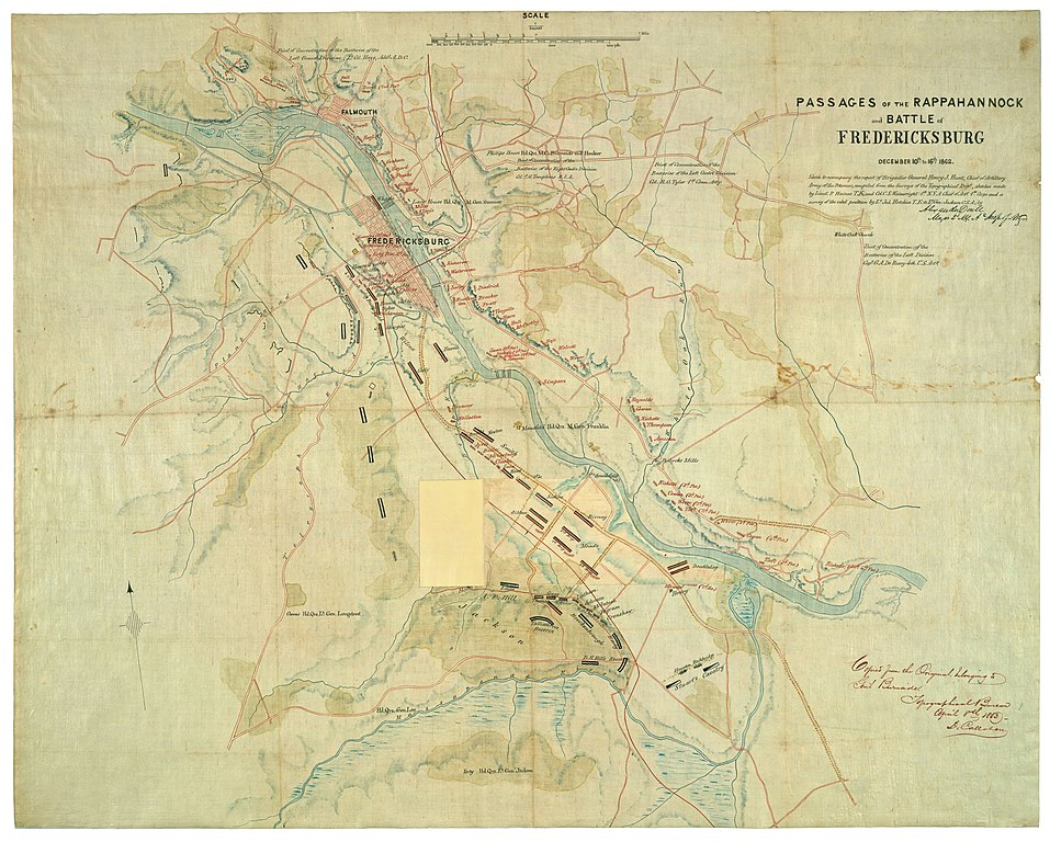
English: "Map originally prepared following the Battle of Fredericksburg in December 1862 ... enhanced by the addition of details from a captured map prepared by topographical engineer Jedediah Hotchkiss for the use of Confederate lietenant general Stonewall Jackson. A significant feature of the map is an overlay (overleaf) depicting the rapidly changing positions of Federal troops during and after their successful crossing of the Rappahannock River"--Virginia in maps, 2000 (atlas). "Sketch to accompany the report of Brigadier General Henry J. Hunt, chief of artillery, Army of the Potomac, compiled from the surveys of the Topographical Dept., sketches made by Lieut. P. Haines [i.e. , Hains] T.E., and Col. C.S. Wainwright 1st N.Y.A., Chief of Arty. 1st Corps and a survey of the rebel position by Lt. Jed. Hotchkiss T.E. to Lt. Gen. Jackson C.S.A., by [signed] Alexander Doull, Major 2d N.Y. Ay. Insp. of Arty." Oriented with north toward the upper left. Relief shown by hachures and shading. Shows Federal and Confederate positions, headquarters of commanding generals, batteries, woodland, and marsh areas. Similar to no. 2.239, Guide to Civil War maps in the National Archives. This item is in the Map Collection of the Library of Virginia; please contact the Library's Archives Research Services department for more information. Available also through the Library of Congress Web site as a raster image. Copy of original version belonging to General Burnside: Alexander Doull. 1862. 66 x 76 cm. C.1, Oct. 2001, source unknown (1968), gift, ALE; c.2, photocopy, LVA, ALE. |
||
| Title | Passages of the Rappahannock and Battle of Fredericksburg, December 10th to 16th, 1862 : copied from the original belonging to Gen'l. Burnside | ||
| Shelf ID | https://www.loc.gov/item/lva0000023/ | ||
| Date | |||
| Source | https://www.loc.gov/item/lva0000023/ | ||
| Author | Callahan, Denis; Doull, Alexander; Hains, Peter C. (Peter Conover); Hotchkiss, Jedediah; Wainwright, Charles S. (Charles Shiels); United States. Topographical Bureau | ||
| Permission (Reusing this file) |
|
||
| Other versions |
|
||
| Location | United States · Fredericksburg · Virginia · Fredericksburg Region | ||
| Part of | Military Battles And Campaigns · American Memory · Civil War Maps · Geography And Map Division | ||
| Subject | Fredericksburg (Va.), Battle Of · Fredericksburg Region (Va.) · Virginia · Civil War · United States · Maps · Fredericksburg, Va., Battle Of · History |


Licensing
[edit]
|
This is a faithful photographic reproduction of a two-dimensional, public domain work of art. The work of art itself is in the public domain for the following reason:
The official position taken by the Wikimedia Foundation is that "faithful reproductions of two-dimensional public domain works of art are public domain".
This photographic reproduction is therefore also considered to be in the public domain in the United States. In other jurisdictions, re-use of this content may be restricted; see Reuse of PD-Art photographs for details. | ||||
File history
Click on a date/time to view the file as it appeared at that time.
| Date/Time | Thumbnail | Dimensions | User | Comment | |
|---|---|---|---|---|---|
| current | 21:07, 15 May 2018 | | 11,190 × 8,977 (23.53 MB) | Fæ (talk | contribs) | LOC Maps https://www.loc.gov/item/lva0000023/ #709 |
You cannot overwrite this file.
File usage on Commons
The following page uses this file: