File:Paris 19th arrondissement map with listings.png
Jump to navigation
Jump to search
Size of this preview: 690 × 600 pixels. Other resolutions: 276 × 240 pixels | 552 × 480 pixels | 883 × 768 pixels | 1,178 × 1,024 pixels | 2,356 × 2,048 pixels | 3,460 × 3,008 pixels.
Original file (3,460 × 3,008 pixels, file size: 1.14 MB, MIME type: image/png)
Captions
Captions
Add a one-line explanation of what this file represents

Summary
[edit]
| Description |
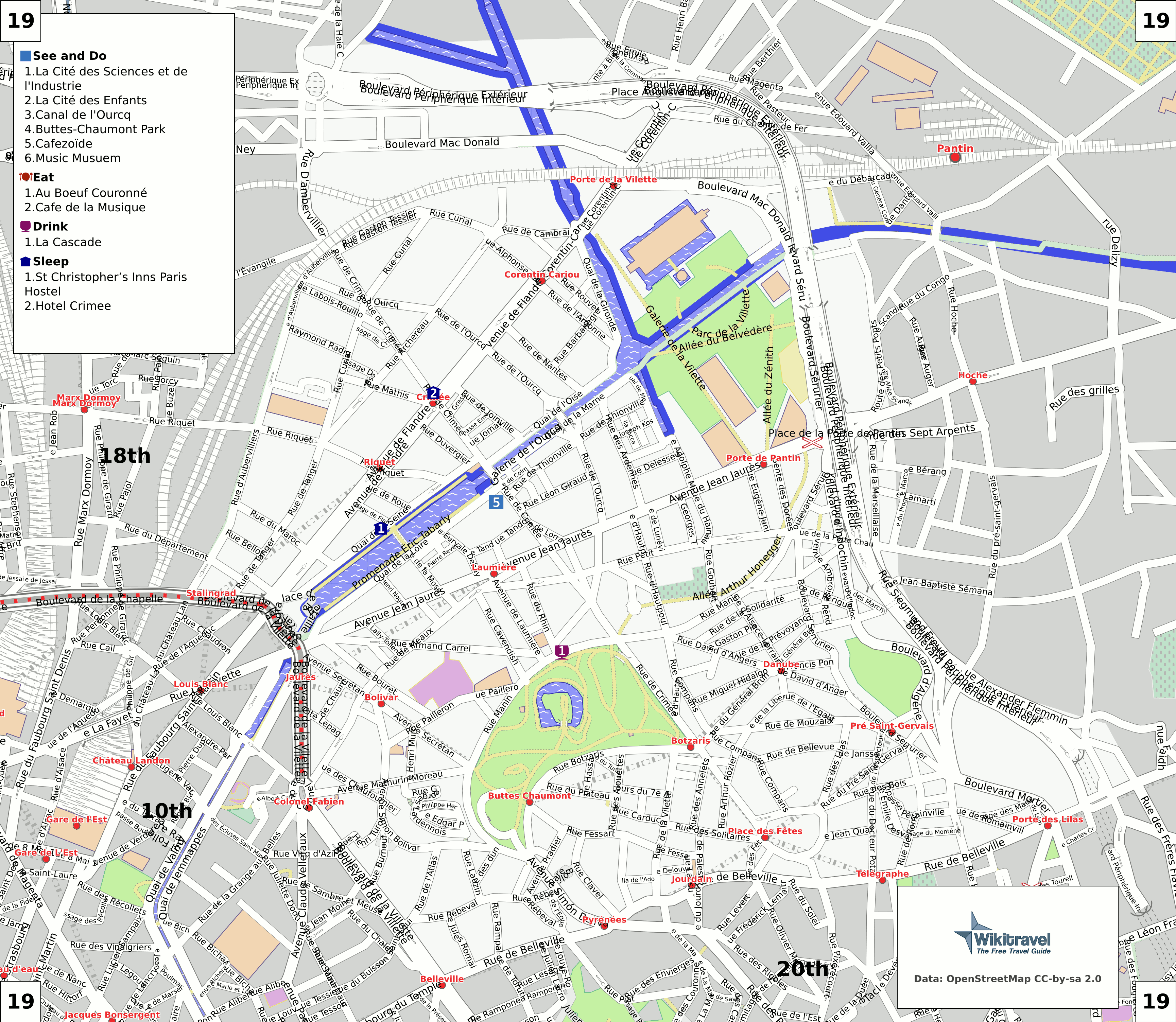
English: Map of the 19st arrondissement of Paris.
Deutsch: Karte des 19. Bezirkes von Paris. |
| Date | |
| Source | Map created by Mark Jaroski for Wikitravel (see at http://wikitravel.org/en/Paris/Maps). Generated from OSM data and Wikitravel listings using this code. |
| Author | Mark Jaroski |
| Permission (Reusing this file) |
ShareAlike 1.0 |
Licensing
[edit]
This file is licensed under Creative Commons ShareAlike 1.0 License.
Creative Commons has retired this legal tool and does not recommend that it be applied to works.
|
Original upload log
[edit]
| This file was imported from Wikivoyage WTS. |
The original description page was here. All following user names refer to wts.wikivoyage-old.
- 2008-08-20 18:03 (WT-shared) Mark[dead link] 3460×3008 (820926 bytes) Generated from OSM and Wikitravel data using [http://wikevent.org/repository/wtp-maps this code]. (Import from wikitravel.org/shared)
- 2008-09-27 12:08 (WT-shared) Mark[dead link] 3460×3008 (818760 bytes) (Import from wikitravel.org/shared)
- 2008-10-30 07:00 (WT-shared) Mark[dead link] 3460×3008 (836839 bytes) (Import from wikitravel.org/shared)
- 2009-01-11 11:42 (WT-shared) Mark[dead link] 3460×3008 (1196279 bytes) (Import from wikitravel.org/shared)
- 2009-01-11 11:53 (WT-shared) Mark[dead link] 3460×3008 (1196173 bytes) (Import from wikitravel.org/shared)
- 2009-05-23 19:34 (WT-shared) Mark[dead link] 3460×3008 (1118281 bytes) (Import from wikitravel.org/shared)
- 2009-05-23 21:24 (WT-shared) Mark[dead link] 3460×3008 (1117802 bytes) (Import from wikitravel.org/shared)
- 2012-09-10 19:41 Atsirlin[dead link] 3460×3008 (1493634 bytes) cleanup
File history
Click on a date/time to view the file as it appeared at that time.
| Date/Time | Thumbnail | Dimensions | User | Comment | |
|---|---|---|---|---|---|
| current | 11:06, 16 February 2009 | | 3,460 × 3,008 (1.14 MB) | NatiSythen (talk | contribs) | {{Information |Description={{en|1=Map of the 19st arrondissement of Paris. }} {{de|1=Karte des 19. Bezirkes von Paris. }} |Source=Map created by Mark Jaroski for Wikitravel (see at http://wikitravel.org/en/Paris/Maps). Generated from OSM data and Wikitrav |
You cannot overwrite this file.
File usage on Commons
The following 3 pages use this file:
File usage on other wikis
The following other wikis use this file:
- Usage on de.wikipedia.org
- Usage on es.wikipedia.org
- Usage on fi.wikivoyage.org
- Usage on fr.wikipedia.org
- Usage on ja.wikipedia.org
- Usage on nl.wikipedia.org