File:Pamir Position.jpg
Jump to navigation
Jump to search
No higher resolution available.
Pamir_Position.jpg (400 × 400 pixels, file size: 85 KB, MIME type: image/jpeg)
Captions
Captions
Add a one-line explanation of what this file represents
Summary
[edit]
| Description |
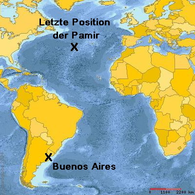
Deutsch: Position im Atlantik, an der 1957 das deutsche Segelschulschiff Pamir unterging, und sein letzter Abfahrtshafen Buenos Aires
English: Position in the Atlantic Ocean at which the German school ship Pamir sank in 1957, and her last port of departure Buenos Aires |
| Date | |
| Source | Interactively created map from http://www.planiglobe.com (markers and labels were added afterwards) |
| Author | http://www.planiglobe.com |
| Permission (Reusing this file) |
Creative Commons Attribution 2.5 License |
Licensing
[edit]
I, the copyright holder of this work, hereby publish it under the following license:
This file is licensed under the Creative Commons Attribution-Share Alike 2.5 Generic license.
- You are free:
- to share – to copy, distribute and transmit the work
- to remix – to adapt the work
- Under the following conditions:
- attribution – You must give appropriate credit, provide a link to the license, and indicate if changes were made. You may do so in any reasonable manner, but not in any way that suggests the licensor endorses you or your use.
- share alike – If you remix, transform, or build upon the material, you must distribute your contributions under the same or compatible license as the original.
Planiglobe license:
| This image is from Planiglobe. All maps hosted on Planiglobe are licensed under the Creative Commons Attribution 2.5 License, but Planiglobe suggests that they not be used for navigational purposes. For the purposes of this license, this clause is considered a disclaimer and not a license restriction. This file is licensed under the Creative Commons Attribution 2.5 Generic license.
|
File history
Click on a date/time to view the file as it appeared at that time.
| Date/Time | Thumbnail | Dimensions | User | Comment | |
|---|---|---|---|---|---|
| current | 16:22, 20 November 2006 | | 400 × 400 (85 KB) | Ibn Battuta (talk | contribs) | {{Information |Description={{de|Position im Atlantik, an der 1957 das deutsche Segelschulschiff Pamir unterging}} {{en|Position in the Atlantic Ocean at which the German school ship Pamir sank in 1957}} |Source=Interactively created map from http://www.pl |
You cannot overwrite this file.
File usage on Commons
There are no pages that use this file.
File usage on other wikis
The following other wikis use this file:
- Usage on de.wikipedia.org
- Usage on pt.wikipedia.org