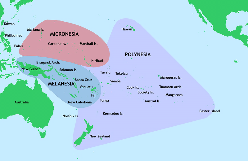
File:Pacific Culture Areas.png

Original file (1,396 × 908 pixels, file size: 666 KB, MIME type: image/png)
Captions
Captions

|
This map image could be re-created using vector graphics as an SVG file. This has several advantages; see Commons:Media for cleanup for more information. If an SVG form of this image is available, please upload it and afterwards replace this template with
{{vector version available|new image name}}.
It is recommended to name the SVG file “Pacific Culture Areas.svg”—then the template Vector version available (or Vva) does not need the new image name parameter. |
Summary
[edit]| DescriptionPacific Culture Areas.png |
English: Major culture areas of Oceania: Micronesia, Melanesia, and Polynesia.
|
|||
| Date | ||||
| Source | Outline: File:World2Hires filled mercator.svg; Map information based on Vaka Moana: Voyages of the Ancestors - the discovery and settlement of the Pacific, ed K.R. Howe, 2008, p57. | |||
| Author | User:Kahuroa | |||
| Other versions |
JPG: File:Pacific Culture Areas.jpg
|
Licensing
[edit]| Public domainPublic domainfalsefalse |
| This work has been released into the public domain by its author, Kahuroa. This applies worldwide. In some countries this may not be legally possible; if so: |
File history
Click on a date/time to view the file as it appeared at that time.
| Date/Time | Thumbnail | Dimensions | User | Comment | |
|---|---|---|---|---|---|
| current | 11:43, 24 August 2017 |  | 1,396 × 908 (666 KB) | Hazhk (talk | contribs) | User created page with UploadWizard |
You cannot overwrite this file.
File usage on Commons
The following page uses this file:
File usage on other wikis
The following other wikis use this file:
- Usage on ar.wikipedia.org
- Usage on az.wikiquote.org
- Usage on bcl.wikipedia.org
- Usage on bn.wikipedia.org
- Usage on ceb.wikipedia.org
- Usage on en.wikipedia.org
- Pacific Ocean
- Melanesia
- Polynesian outlier
- Portal:Oceania
- RNZ Pacific
- Post-classical history
- User:Kazkaskazkasako/Books/Physical sciences
- User:Ziraro
- Wikipedia:Graphics Lab/Map workshop/Archive/Feb 2018
- Wikipedia:Graphics Lab/Map workshop/Archive/Sep 2018
- Pacific Islands home front during World War II
- Portal:Oceans
- Wikipedia:Graphics Lab/Map workshop/Archive/Sep 2020
- Wikipedia:Graphics Lab/Map workshop/Archive/Dec 2020
- Naval Base Ulithi
- Wikipedia:Graphics Lab/Map workshop/Archive/Jun 2021
- US Naval Base Carolines
- Naval Base Kossol Roads
- Wikipedia:WikiProject Squatting/Draft/Squatting in Oceania
- Usage on en.wikinews.org
- Usage on fa.wikipedia.org
- Usage on fj.wikipedia.org
- Usage on fr.wikipedia.org
- Usage on he.wikipedia.org
- Usage on hi.wikipedia.org
- Usage on hy.wikipedia.org
- Usage on id.wikipedia.org
- Usage on incubator.wikimedia.org
- Usage on it.wikipedia.org
View more global usage of this file.
Metadata
This file contains additional information such as Exif metadata which may have been added by the digital camera, scanner, or software program used to create or digitize it. If the file has been modified from its original state, some details such as the timestamp may not fully reflect those of the original file. The timestamp is only as accurate as the clock in the camera, and it may be completely wrong.
| Horizontal resolution | 37.79 dpc |
|---|---|
| Vertical resolution | 37.79 dpc |


