File:PIA17076 fig1-SolanderPoint.tif
Jump to navigation
Jump to search

Size of this JPG preview of this TIF file: 800 × 411 pixels. Other resolutions: 320 × 164 pixels | 640 × 329 pixels | 1,024 × 526 pixels | 1,280 × 657 pixels | 3,000 × 1,540 pixels.
Original file (3,000 × 1,540 pixels, file size: 4.73 MB, MIME type: image/tiff)
Captions
Captions
Add a one-line explanation of what this file represents
Summary
[edit]| Description |
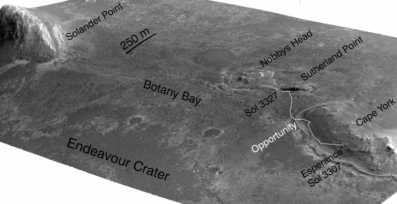
English: A stereo pair of images from taken from Mars orbit were used to generate a digital elevation model that is the basis for this simulated perspective view of "Cape York," "Botany Bay," and "Solander Point" on the western rim of Endeavour Crater. The view is from the crater interior looking toward the southwest, and the vertical exaggeration is fivefold. |
| Date | |
| Source | http://photojournal.jpl.nasa.gov/catalog/PIA17076 |
| Author | NASA/JPL-Caltech/UA/OSU |
Licensing
[edit]| This file is in the public domain in the United States because it was solely created by NASA. NASA copyright policy states that "NASA material is not protected by copyright unless noted". (See Template:PD-USGov, NASA copyright policy page or JPL Image Use Policy.) | ||
 |
Warnings:
|
File history
Click on a date/time to view the file as it appeared at that time.
| Date/Time | Thumbnail | Dimensions | User | Comment | |
|---|---|---|---|---|---|
| current | 21:16, 16 November 2013 |  | 3,000 × 1,540 (4.73 MB) | MoreInput (talk | contribs) | User created page with UploadWizard |
You cannot overwrite this file.
File usage on Commons
The following page uses this file:
File usage on other wikis
The following other wikis use this file:
- Usage on de.wikipedia.org
- Usage on en.wikipedia.org
- Usage on www.wikidata.org