File:Péninsule ibérique en 875.png
Jump to navigation
Jump to search

Size of this preview: 800 × 600 pixels. Other resolutions: 320 × 240 pixels | 640 × 480 pixels | 1,024 × 768 pixels | 1,280 × 960 pixels | 2,000 × 1,500 pixels.
Original file (2,000 × 1,500 pixels, file size: 859 KB, MIME type: image/png)
Captions
Captions
Add a one-line explanation of what this file represents
Summary
[edit]
| Description |
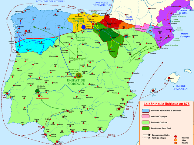
Français : Carte de la péninsule de 850 à 875, retraçant les grands évènements de l'époque |
| Date | |
| Source | Own work |
| Author | Elryck |
Licensing
[edit]
I, the copyright holder of this work, hereby publish it under the following license:
This file is licensed under the Creative Commons Attribution-Share Alike 4.0 International license.
- You are free:
- to share – to copy, distribute and transmit the work
- to remix – to adapt the work
- Under the following conditions:
- attribution – You must give appropriate credit, provide a link to the license, and indicate if changes were made. You may do so in any reasonable manner, but not in any way that suggests the licensor endorses you or your use.
- share alike – If you remix, transform, or build upon the material, you must distribute your contributions under the same or compatible license as the original.
File history
Click on a date/time to view the file as it appeared at that time.
| Date/Time | Thumbnail | Dimensions | User | Comment | |
|---|---|---|---|---|---|
| current | 19:17, 17 August 2020 | | 2,000 × 1,500 (859 KB) | Elryck (talk | contribs) | Nomenclatures |
| 12:55, 13 August 2020 |  | 2,000 × 1,500 (874 KB) | Elryck (talk | contribs) | Correction de la légende corrompue lors d'une sauvegarde | |
| 11:54, 13 August 2020 |  | 2,000 × 1,500 (883 KB) | Elryck (talk | contribs) | Version 1.0 | |
| 10:22, 11 August 2020 |  | 2,000 × 1,500 (866 KB) | Elryck (talk | contribs) | Ajout de la seigneurie de Biscaye, correction de frontières. | |
| 18:31, 7 August 2020 |  | 2,000 × 1,500 (861 KB) | Elryck (talk | contribs) | Corrections mineures | |
| 09:24, 7 August 2020 |  | 2,000 × 1,500 (859 KB) | Elryck (talk | contribs) | Rectification frontière navarraise | |
| 07:20, 7 August 2020 |  | 2,000 × 1,500 (859 KB) | Elryck (talk | contribs) | Uploaded own work with UploadWizard |
You cannot overwrite this file.
File usage on Commons
The following page uses this file:
File usage on other wikis
The following other wikis use this file:
- Usage on an.wikipedia.org
- Usage on en.wikipedia.org
- Usage on es.wikipedia.org
- Usage on fr.wikipedia.org
- Comté de Barcelone
- Omeyyades de Cordoue
- Royaume de Navarre
- Royaume des Asturies
- Rodrigue de Castille
- Alphonse III (roi des Asturies)
- Comtés catalans
- Histoire d'al-Andalus
- Âge des Vikings
- Banu Qasi
- García Ier (roi de Pampelune)
- Muhammad Ier (Omeyyade)
- Émirat de Cordoue
- Al-Andalus
- Royaume de Pampelune
- Histoire de l'Aragon
- Comté d'Aragon
- Comté de Castille
- Incursions vikings dans le sud de l'Europe
- Portugal à la Reconquista
- Usage on gl.wikipedia.org
- Usage on it.wikipedia.org
- Usage on la.wikipedia.org
- Usage on pt.wikipedia.org
Metadata
Categories:
- Iberian kingdoms
- Maps of Al-Andalus
- Maps of the history of Asturias
- Maps of the Marca Hispanica
- Maps of the County of Barcelona
- Maps of Catalan counties
- Maps of 9th-century Iberian Peninsula
- Territorial evolution of Spain
- Reconquista maps of the Iberian Peninsula
- French-language maps showing history of Europe
- Spain in the 870s
- Maps of the County of Aragon
- Maps of the County of Castile