File:Péninsule ibérique en 1479.png
Jump to navigation
Jump to search
Size of this preview: 800 × 600 pixels. Other resolutions: 320 × 240 pixels | 640 × 480 pixels | 1,024 × 768 pixels | 1,280 × 960 pixels | 2,000 × 1,500 pixels.
Original file (2,000 × 1,500 pixels, file size: 1,012 KB, MIME type: image/png)
Captions
Captions
Add a one-line explanation of what this file represents
Summary
[edit]
| Description |
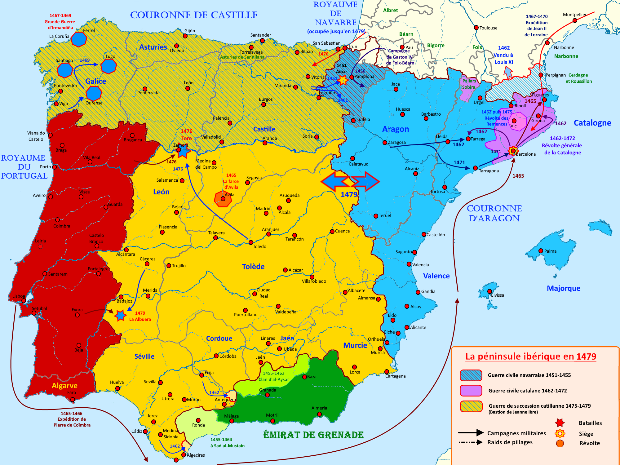
Français : Carte de la péninsule ibérique en 1479 illustrant les principaux évènements de l'époque |
| Date | |
| Source | Own work |
| Author | Elryck |
Licensing
[edit]
I, the copyright holder of this work, hereby publish it under the following license:
This file is licensed under the Creative Commons Attribution-Share Alike 4.0 International license.
- You are free:
- to share – to copy, distribute and transmit the work
- to remix – to adapt the work
- Under the following conditions:
- attribution – You must give appropriate credit, provide a link to the license, and indicate if changes were made. You may do so in any reasonable manner, but not in any way that suggests the licensor endorses you or your use.
- share alike – If you remix, transform, or build upon the material, you must distribute your contributions under the same or compatible license as the original.
File history
Click on a date/time to view the file as it appeared at that time.
| Date/Time | Thumbnail | Dimensions | User | Comment | |
|---|---|---|---|---|---|
| current | 19:04, 24 August 2020 | | 2,000 × 1,500 (1,012 KB) | Elryck (talk | contribs) | Ajout des révoltes d'Irmandiña |
| 12:32, 23 August 2020 |  | 2,000 × 1,500 (1,000 KB) | Elryck (talk | contribs) | Erreur d'une date | |
| 09:55, 23 August 2020 |  | 2,000 × 1,500 (1,000 KB) | Elryck (talk | contribs) | Uploaded own work with UploadWizard |
You cannot overwrite this file.
File usage on Commons
The following page uses this file:
File usage on other wikis
The following other wikis use this file:
- Usage on ca.wikipedia.org
- Usage on de.wikipedia.org
- Usage on en.wikipedia.org
- Usage on fr.wikipedia.org
- Couronne d'Aragon
- Jean II (roi d'Aragon)
- Couronne de Castille
- Histoire du Portugal
- Alphonse V (roi de Portugal)
- Royaume de Grenade
- Royaume de Navarre
- Henri IV (roi de Castille)
- Jeanne de Castille
- Isabelle la Catholique
- Guerre de Succession de Castille
- Monarchie catholique espagnole
- Reconquista
- Guerre civile de Navarre
- Yusuf V de Grenade
- Mohammed XI de Grenade
- Sad al-Mustain
- Abu al-Hasan Ali de Grenade
- Gran Guerra Irmandiña
- Guerre civile catalane
- Principauté de Catalogne
- Usage on uk.wikipedia.org
Metadata
Categories:
- French-language maps showing history of Europe
- Maps of 15th-century Iberian Peninsula
- Spain in the 15th century
- Reconquista maps of the Iberian Peninsula
- Iberian kingdoms
- Maps of Al-Andalus
- Territorial evolution of Spain
- Maps of the Crown of Aragon
- Maps of the Crown of Castile
- Maps of the Emirate of Granada
- Portugal in the 15th century
- 1479 in Spain
- Maps showing 1479