File:Outline of post-war new world map. LOC gm70005331.jpg
Jump to navigation
Jump to search

Size of this preview: 800 × 565 pixels. Other resolutions: 320 × 226 pixels | 640 × 452 pixels | 1,024 × 723 pixels | 1,280 × 904 pixels | 2,560 × 1,808 pixels | 11,728 × 8,283 pixels.
Original file (11,728 × 8,283 pixels, file size: 12.01 MB, MIME type: image/jpeg)
Captions
Captions
Add a one-line explanation of what this file represents
Summary
[edit]| Warning | The original file is very high-resolution. It might not load properly or could cause your browser to freeze when opened at full size. |
|---|
| Description |
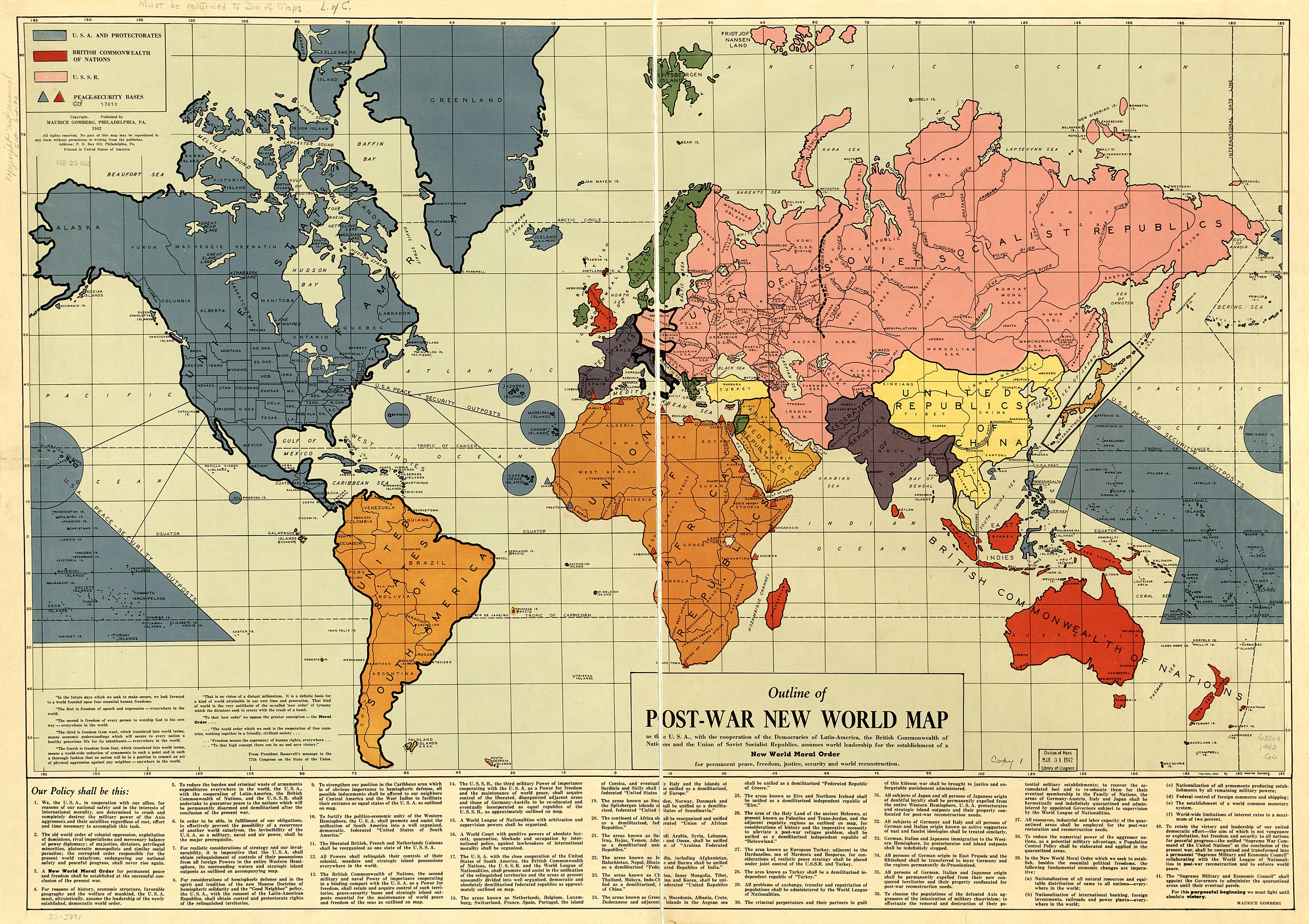
English: F17019 U.S. Copyright Office Scale ca. 1:30,000,000. Shows protectorates and peace-security bases. Available also through the Library of Congress Web site as a raster image. Includes text. AACR2: 650/1; 650/2 |
||
| Title | Outline of post-war new world map. | ||
| Shelf ID | G3200 1942 .G6 | ||
| Date | |||
| Source | https://www.loc.gov/item/gm70005331/ | ||
| Author | Gomberg, Maurice | ||
| Permission (Reusing this file) |
|
||
| Other versions |
|
||
| Location | Earth | ||
| Part of | Military Battles And Campaigns · General Maps · Catalog · American Memory · Geography And Map Division | ||
| Subject | Earth · World Maps · Protectorates |


Licensing
[edit]
This work is in the public domain in the United States because it is a work prepared by an officer or employee of the United States Government as part of that person’s official duties under the terms of Title 17, Chapter 1, Section 105 of the US Code.
Note: This only applies to original works of the Federal Government and not to the work of any individual U.S. state, territory, commonwealth, county, municipality, or any other subdivision. This template also does not apply to postage stamp designs published by the United States Postal Service since 1978. (See § 313.6(C)(1) of Compendium of U.S. Copyright Office Practices). It also does not apply to certain US coins; see The US Mint Terms of Use.
|
 | |
| This file has been identified as being free of known restrictions under copyright law, including all related and neighboring rights. | ||
File history
Click on a date/time to view the file as it appeared at that time.
| Date/Time | Thumbnail | Dimensions | User | Comment | |
|---|---|---|---|---|---|
| current | 17:47, 15 May 2018 | | 11,728 × 8,283 (12.01 MB) | Fæ (talk | contribs) | LOC Maps https://www.loc.gov/item/gm70005331/ #636 |
You cannot overwrite this file.
File usage on Commons
The following page uses this file: