File:Osterwitz Stefflpeter.jpg
Jump to navigation
Jump to search

Size of this preview: 747 × 600 pixels. Other resolutions: 299 × 240 pixels | 598 × 480 pixels | 956 × 768 pixels | 1,275 × 1,024 pixels | 2,550 × 2,048 pixels | 8,393 × 6,741 pixels.
Original file (8,393 × 6,741 pixels, file size: 15.51 MB, MIME type: image/jpeg)
Captions
Captions
Add a one-line explanation of what this file represents
| Warning | The original file is very high-resolution. It might not load properly or could cause your browser to freeze when opened at full size. |
|---|
Summary
[edit]
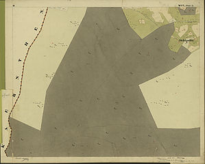
| Description | historische Vermessungskarte: österreichischer Kataster, Gemeinde Osterwitz. 1823. Blatt II Osterwitz Winkel, Einzugsgebiet des Stoffbaches, südlich See Eben, Gebiet Steffelpeter, Talschluss des Rettenbachtales |
| Date | |
| Source | Urmappe des österreichischen Katasters 1823 |
| Author | Kaiserreich Österreich. |
| Permission (Reusing this file) |
amtliches Werk der 1. Hälfte des 19. Jahrhunderts, freies Werk |
Licensing
[edit]
|
This work is in the public domain in its country of origin and other countries and areas where the copyright term is the author's life plus 70 years or fewer. | |
| This file has been identified as being free of known restrictions under copyright law, including all related and neighboring rights. | |
File history
Click on a date/time to view the file as it appeared at that time.
| Date/Time | Thumbnail | Dimensions | User | Comment | |
|---|---|---|---|---|---|
| current | 19:40, 25 September 2008 | | 8,393 × 6,741 (15.51 MB) | Josef Moser (talk | contribs) | {{Information |Description=historische Vermessungskarte: österreichischer Kataster, Gemeinde Osterwitz. 1823. Blatt II Osterwitz Winkel, Einzugsgebiet des Stoffbaches, Talschluss des Rettenbachtales |Source=Urmappe des österreichischen Katasters 1823 |D |
You cannot overwrite this file.
File usage on Commons
The following page uses this file:
File usage on other wikis
The following other wikis use this file: