File:Olives Farm from the air - geograph.org.uk - 611431.jpg
Olives_Farm_from_the_air_-_geograph.org.uk_-_611431.jpg (640 × 480 pixels, file size: 39 KB, MIME type: image/jpeg)
Captions
Captions
Summary
[edit]
| Description |
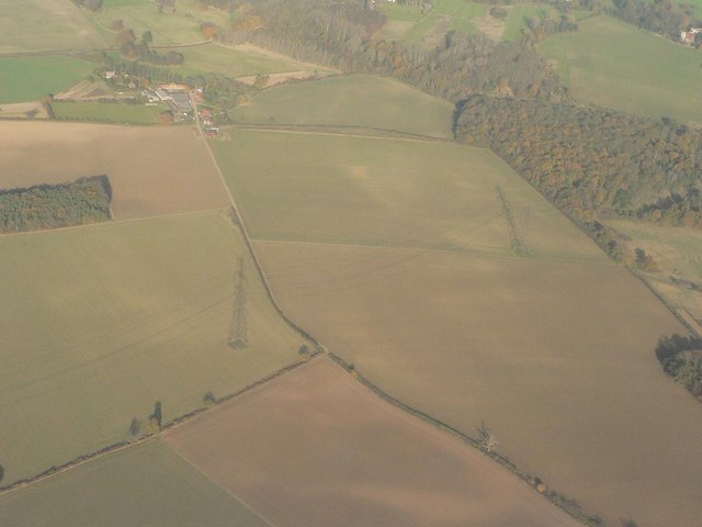
English: Olives Farm from the air An excellent interpretation of the map of the southeastern part of this square can be gained from this picture.
The pylon more central in the picture is just south of the square's edge; the right-hand pylon is just within the eastern extremity of the square. (Note that the first pylon is actually partly obscured by its much longer shadow a concept that is fathomable by looking at the second pylon.) You can vividly see Lord's Wood, out of square to the right. Moving north, you can see that the path bends to the right after passing under the electricity cables, then the track to the right leads to Lord's Wood and to the left to Square Spring, a plantation that is named on the 1:25,000 map and marked on the 1:50,000. Then the path approaches the farm itself, although the moat marked on the map is indistinct, possibly obscured by trees. The B180 Hunsdon Road can just be made out at the very top of the picture. By following the route of the stream northeastwards from the farmhouse (on the 1:25,000 map), one might conclude that the area of woodland has been altered since the map was published. This picture was taken from a Belfast-London flight. |
| Date | |
| Source | From geograph.org.uk |
| Author | Chris Downer |
| Attribution (required by the license) | Chris Downer / Olives Farm from the air / |
| Object location | | View this and other nearby images on: OpenStreetMap |
|---|
_heading:22.00&language=en)
Licensing
[edit]

|
This image was taken from the Geograph project collection. See this photograph's page on the Geograph website for the photographer's contact details. The copyright on this image is owned by Chris Downer and is licensed for reuse under the Creative Commons Attribution-ShareAlike 2.0 license.
|
- You are free:
- to share – to copy, distribute and transmit the work
- to remix – to adapt the work
- Under the following conditions:
- attribution – You must give appropriate credit, provide a link to the license, and indicate if changes were made. You may do so in any reasonable manner, but not in any way that suggests the licensor endorses you or your use.
- share alike – If you remix, transform, or build upon the material, you must distribute your contributions under the same or compatible license as the original.
File history
Click on a date/time to view the file as it appeared at that time.
| Date/Time | Thumbnail | Dimensions | User | Comment | |
|---|---|---|---|---|---|
| current | 03:12, 7 February 2011 | | 640 × 480 (39 KB) | GeographBot (talk | contribs) | == {{int:filedesc}} == {{Information |description={{en|1=Olives Farm from the air An excellent interpretation of the map of the southeastern part of this square can be gained from this picture. The pylon more central in the picture is just south of the |
You cannot overwrite this file.
File usage on Commons
There are no pages that use this file.