Category:Stanstead Abbotts
Jump to navigation
Jump to search
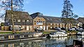
English: Stanstead Abbotts is a small village at the south of East Hertfordshire. To west or north are a rural buffer within the bounds of Ware, Amwell (officially Great Amwell) and St Margarets or Stanstead St Margarets, a long projection of Hoddesdon's continguous urban area. All these places are alongside the Lea in the Lea (or Lee) Valley. It is 5 miles from Harlow, Essex and from the county town Hertford.
village in Hertfordshire, UK  | |||||
| Upload media | |||||
| Instance of | |||||
|---|---|---|---|---|---|
| Location | East Hertfordshire, Hertfordshire, East of England, England | ||||
| Population |
| ||||
 | |||||
Subcategories
This category has the following 5 subcategories, out of 5 total.
Media in category "Stanstead Abbotts"
The following 166 files are in this category, out of 166 total.
-
 2022-01-29 Bridge over the Lea, Stanstead Abbotts & Stanstead St Margarets.jpg 4,032 × 3,024; 4.31 MB
-
-
 2022-01-29 St Andrew's Primary School, Stanstead Abbotts.jpg 3,940 × 2,216; 2.55 MB
-
 2022-01-29 Stanstead Hall, Stanstead Abbotts.jpg 3,918 × 2,939; 2.67 MB
-
 2022-01-29 The Mill, Stanstead Abbotts.jpg 3,428 × 2,571; 2.5 MB
-

-
 A patchwork of fields - geograph.org.uk - 611922.jpg 640 × 480; 46 KB
-
 A414 crossing the River Lee - geograph.org.uk - 3177039.jpg 4,320 × 3,240; 5.91 MB
-
 A414 towards Harlow - geograph.org.uk - 6218183.jpg 800 × 600; 105 KB
-
 B180 Hunsdon Road - geograph.org.uk - 6705751.jpg 1,024 × 684; 325 KB
-
 B180 Hunsdon Road - geograph.org.uk - 6705784.jpg 1,024 × 768; 384 KB
-
 Bend in the River Stort - geograph.org.uk - 2429975.jpg 1,024 × 768; 323 KB
-
 Boats moored at Stanstead Abbotts - geograph.org.uk - 137086.jpg 640 × 419; 71 KB
-
 Bridge over the River Stort - geograph.org.uk - 3502856.jpg 640 × 430; 108 KB
-
 Bulls in a field near to Mead Wood - geograph.org.uk - 5128854.jpg 4,608 × 3,456; 4.11 MB
-
 By Roydon Lock - geograph.org.uk - 3884939.jpg 640 × 480; 172 KB
-
 Cappell Lane, Stanstead Abbotts - geograph.org.uk - 3132623.jpg 3,692 × 2,232; 2.07 MB
-
 Cappell Lane, Stanstead Abbotts - geograph.org.uk - 3509709.jpg 1,024 × 768; 225 KB
-
 Cats Hill Stanstead Abbotts - geograph.org.uk - 840264.jpg 640 × 360; 68 KB
-
 Cereal crop near Stanstead Bury Farm - geograph.org.uk - 6218171.jpg 800 × 585; 124 KB
-
 Cereal crop off Hunsdon Road (B180) - geograph.org.uk - 6218200.jpg 800 × 600; 131 KB
-
 Cereal crop towards Halfway House Farm - geograph.org.uk - 6218191.jpg 800 × 600; 116 KB
-
 Church at Stanstead Abbotts – view east - geograph.org.uk - 5128909.jpg 4,608 × 3,456; 4.41 MB
-
 Church at Stanstead Abbotts – view north - geograph.org.uk - 5128906.jpg 4,608 × 3,456; 5.1 MB
-
 Church at Stanstead Abbotts – view south - geograph.org.uk - 5128911.jpg 4,608 × 3,456; 4.22 MB
-
 Cruising along the River. - geograph.org.uk - 137088.jpg 640 × 309; 35 KB
-
 Entering Stanstead Abbotts on the B181 - geograph.org.uk - 4701654.jpg 2,048 × 1,536; 1.09 MB
-
 Entrance to (the former) Rye House - geograph.org.uk - 4325281.jpg 640 × 480; 87 KB
-
 Estate House, Easneye Wood - geograph.org.uk - 3140341.jpg 3,408 × 2,412; 2.03 MB
-
 Exit from the A414 on the B181 - geograph.org.uk - 4701226.jpg 2,048 × 1,536; 1.49 MB
-
 Exit gate at Rye Meads Nature Reserve - geograph.org.uk - 3177021.jpg 4,320 × 3,240; 5.78 MB
-
 Fallen Tree - geograph.org.uk - 320269.jpg 640 × 428; 96 KB
-
 Fallen tree on the Harcamlow Way - geograph.org.uk - 5129122.jpg 4,608 × 3,456; 4.74 MB
-
 Farmland by the River Stort - geograph.org.uk - 3502851.jpg 640 × 430; 62 KB
-
 Farmland looking NW from Hunsdon Road - geograph.org.uk - 6705472.jpg 1,024 × 768; 310 KB
-
 Field near Briggens Home Farm - geograph.org.uk - 5129120.jpg 4,608 × 3,456; 5.83 MB
-
 Fields by Rye Road, Rye Meads - geograph.org.uk - 4701653.jpg 2,048 × 1,536; 1.6 MB
-
 Fields looking east from Hunsdon Road, B180 - geograph.org.uk - 6705769.jpg 1,024 × 768; 327 KB
-

-

-
 Footpath in Rye Meads Nature Reserve - geograph.org.uk - 3176993.jpg 4,320 × 3,240; 5.48 MB
-
 Footpath sign and junction at Rye Meads Nature Reserve - geograph.org.uk - 3177046.jpg 4,320 × 3,240; 5.53 MB
-

-
 Footpath sign at Rye Meads Nature Reserve - geograph.org.uk - 3176986.jpg 4,320 × 3,240; 5.59 MB
-
 Former route of A414 - geograph.org.uk - 4594712.jpg 640 × 480; 181 KB
-
 Gargoyles, Rye House Gatehouse - geograph.org.uk - 5307542.jpg 4,608 × 3,456; 5.19 MB
-
 Gate into young plantation - geograph.org.uk - 6705416.jpg 1,024 × 768; 494 KB
-
 Giant pylon off the Harcamlow Way - geograph.org.uk - 5316367.jpg 4,608 × 3,456; 3.65 MB
-
 Graveyard, Stanstead Abbotts old church - geograph.org.uk - 6705444.jpg 1,024 × 768; 453 KB
-
 Grazing near Home Farm - geograph.org.uk - 6218190.jpg 800 × 600; 121 KB
-
 Greater Anglia train crossing the River Stort at Roydon - geograph.org.uk - 6095166.jpg 5,202 × 3,465; 3.24 MB
-
 Halfway House - geograph.org.uk - 320233.jpg 640 × 428; 118 KB
-
 Halfway House - geograph.org.uk - 3885003.jpg 640 × 480; 99 KB
-
 Harcamlow Way bordering Moat Wood - geograph.org.uk - 5214350.jpg 4,608 × 3,456; 5.87 MB
-
 Harcamlow Way north of Stanstead Lodge - geograph.org.uk - 5129118.jpg 4,608 × 3,456; 5.23 MB
-

-
 House and Turret - geograph.org.uk - 3175714.jpg 3,772 × 2,232; 1.74 MB
-
 House by the River Lea, Rye House - geograph.org.uk - 4701650.jpg 2,048 × 1,536; 1.5 MB
-
 House on Kitten Lane, Stanstead Abbotts - geograph.org.uk - 6218186.jpg 800 × 600; 144 KB
-
 Houses on Hunsdon Road, Stanstead Abbotts - geograph.org.uk - 4701655.jpg 2,048 × 1,536; 1.49 MB
-
 Houses on Rye Road - geograph.org.uk - 6217523.jpg 800 × 463; 102 KB
-
 Houses on Rye Road, Rye Meads - geograph.org.uk - 4701270.jpg 2,048 × 1,536; 959 KB
-
 Hunsdon Road (B180) - geograph.org.uk - 6218189.jpg 800 × 600; 135 KB
-
 Hunsdon Road Cottages - geograph.org.uk - 6218187.jpg 800 × 600; 165 KB
-
 Indian restaurant in Stanstead Abbotts - geograph.org.uk - 4701658.jpg 2,028 × 1,508; 991 KB
-
 Inj the Stort Valley - geograph.org.uk - 3502848.jpg 640 × 430; 59 KB
-
 Kingfisher - geograph.org.uk - 3437040.jpg 4,074 × 3,382; 6.59 MB
-
 Kingfisher at Rye Meads Nature Reserve - geograph.org.uk - 3528198.jpg 3,543 × 1,993; 3.45 MB
-
 Kitten Lane - geograph.org.uk - 1447138.jpg 640 × 480; 232 KB
-
 Kitten Lane, Stanstead Abbotts - geograph.org.uk - 6705463.jpg 1,024 × 768; 571 KB
-
 Lake at Rye Meads Nature Reserve - geograph.org.uk - 3177000.jpg 4,320 × 3,240; 5.53 MB
-
 Lea Navigation - geograph.org.uk - 3550453.jpg 640 × 451; 32 KB
-
 Lea Navigation at Stanstead Abbotts - geograph.org.uk - 3132591.jpg 1,600 × 1,025; 467 KB
-
 Level crossing, Roydon station - geograph.org.uk - 3525096.jpg 4,320 × 3,240; 3.48 MB
-
 Monument, St. James's churchyard - geograph.org.uk - 6705457.jpg 768 × 1,024; 643 KB
-

-
 National Cycle Route 1, Rye Meads - geograph.org.uk - 6217543.jpg 800 × 600; 177 KB
-
 Newgate Wood - geograph.org.uk - 396044.jpg 640 × 480; 60 KB
-
 Newlands - geograph.org.uk - 320307.jpg 640 × 428; 89 KB
-
 Newly laid hedge in Essex - geograph.org.uk - 2840402.jpg 4,752 × 3,168; 5.75 MB
-
 No Entry - geograph.org.uk - 4917214.jpg 640 × 424; 99 KB
-
 Olives Farm from the air - geograph.org.uk - 611431.jpg 640 × 480; 39 KB
-
 Otter Hide at Rye Meads Nature Reserve - geograph.org.uk - 3177030.jpg 4,320 × 3,240; 5.87 MB
-
 Over the fields towards Little Briggens - geograph.org.uk - 3884994.jpg 640 × 480; 124 KB
-
 Over the fields towards Thirsty Spring - geograph.org.uk - 6705479.jpg 1,024 × 768; 302 KB
-
 Passing Roydon Station - geograph.org.uk - 2189353.jpg 640 × 421; 61 KB
-
 Pond next to the Hertfordshire Way - geograph.org.uk - 5214352.jpg 4,608 × 3,456; 5.31 MB
-
 Pre-worboys sign on Rye Road, Rye Meads - geograph.org.uk - 4703040.jpg 2,048 × 1,536; 1.54 MB
-
 Pumping station, Rye Meads - geograph.org.uk - 6217534.jpg 800 × 575; 87 KB
-
 Pylon - geograph.org.uk - 6684566.jpg 1,024 × 684; 99 KB
-
 Railway bridge over River Stort at Roydon - geograph.org.uk - 6095164.jpg 5,202 × 3,465; 3.53 MB
-
 Railway bridge over the River Stort - geograph.org.uk - 3502842.jpg 640 × 430; 79 KB
-
 Railway bridge, Rye House - geograph.org.uk - 5307545.jpg 4,608 × 3,456; 4.38 MB
-
 River Ash - geograph.org.uk - 5128857.jpg 4,608 × 3,456; 5.3 MB
-
 River Ash north of Easneye College - geograph.org.uk - 5331176.jpg 4,608 × 3,456; 6.37 MB
-
 River Lea at St. Margaret's - geograph.org.uk - 3492697.jpg 640 × 480; 55 KB
-

-
 River Lea near Hoddesdon - geograph.org.uk - 3492733.jpg 640 × 480; 70 KB
-
 River Lee - geograph.org.uk - 3177013.jpg 4,320 × 3,240; 5.83 MB
-
 River Stort - geograph.org.uk - 3488652.jpg 640 × 430; 106 KB
-
 River Stort - geograph.org.uk - 3502844.jpg 640 × 430; 47 KB
-
 Roydon , derelict lodge - geograph.org.uk - 6325306.jpg 768 × 1,024; 764 KB
-
 Rye House Gatehouse (2) - geograph.org.uk - 4325297.jpg 640 × 480; 88 KB
-
 Rye House Gatehouse - doorway - geograph.org.uk - 4325303.jpg 480 × 640; 98 KB
-
 Rye House Gatehouse - geograph.org.uk - 3299094.jpg 640 × 480; 100 KB
-
 Rye House gatehouse - geograph.org.uk - 3525106.jpg 4,320 × 3,240; 2.82 MB
-
 Rye House Gatehouse - geograph.org.uk - 4325294.jpg 640 × 480; 84 KB
-
 Rye House Gatehouse - geograph.org.uk - 5307540.jpg 4,608 × 3,456; 4.05 MB
-
 Rye House Marsh - geograph.org.uk - 4953096.jpg 640 × 480; 139 KB
-
 Rye House Power Plant from Glen Faba - geograph.org.uk - 5221608.jpg 4,608 × 3,456; 4.83 MB
-
 Rye House pub across the canal - geograph.org.uk - 5307543.jpg 4,608 × 3,456; 4.16 MB
-
 Rye Meads from the air - geograph.org.uk - 4680536.jpg 640 × 480; 102 KB
-
 Rye Meads Nature Reserve - geograph.org.uk - 3176964.jpg 4,320 × 3,240; 6.07 MB
-
 Rye Meads Nature Reserve - geograph.org.uk - 3176974.jpg 4,320 × 3,240; 5.64 MB
-
 Rye Meads Nature Reserve - geograph.org.uk - 3176979.jpg 4,320 × 3,240; 5.49 MB
-
 Rye Meads Nature Reserve Visitor Centre - geograph.org.uk - 3177091.jpg 4,320 × 3,240; 4.44 MB
-
 Rye Road - geograph.org.uk - 3177060.jpg 4,320 × 3,240; 5.45 MB
-
 Rye Road towards Rye Meads - geograph.org.uk - 6217529.jpg 800 × 600; 133 KB
-
 Rye Road, Rye Meads - geograph.org.uk - 4701651.jpg 2,048 × 1,536; 1.09 MB
-
 Rye Road, Rye Meads - geograph.org.uk - 4701652.jpg 2,048 × 1,536; 1.5 MB
-
 Rye Road, Rye Meads - geograph.org.uk - 4703039.jpg 2,046 × 1,534; 1.55 MB
-
 Rye Road, Rye Meads - geograph.org.uk - 6217541.jpg 800 × 600; 169 KB
-
 Sewage works at Rye Meads - geograph.org.uk - 5462073.jpg 3,264 × 2,448; 3.53 MB
-
 Sewage works on Rye Road - geograph.org.uk - 4701219.jpg 2,048 × 1,536; 1.48 MB
-
 Sharp bend in the B181 towards Roydon - geograph.org.uk - 6218170.jpg 800 × 600; 212 KB
-
 Sharp bend in the B181, Stanstead Bury - geograph.org.uk - 6218174.jpg 800 × 600; 211 KB
-
 Sign for Halfway House, Hunsdon Road - geograph.org.uk - 5129130.jpg 4,608 × 3,456; 4.01 MB
-
 St. James's Church, Stanstead Abbotts - geograph.org.uk - 6218178.jpg 800 × 600; 167 KB
-
 Stanstead Abbotts , The Clock House - geograph.org.uk - 5983821.jpg 1,151 × 1,600; 468 KB
-
 Stanstead Abbotts old church - geograph.org.uk - 6705421.jpg 1,024 × 768; 359 KB
-
 Stanstead Abbotts old church - geograph.org.uk - 6705431.jpg 1,024 × 768; 536 KB
-
 Stanstead Abbotts, B180 Hunsdon Road - geograph.org.uk - 2194196.jpg 640 × 480; 126 KB
-

-

-
-
 Stanstead Bury Farm - geograph.org.uk - 320225.jpg 640 × 428; 96 KB
-
 Stort Walkway sign at Roydon - geograph.org.uk - 6220171.jpg 4,608 × 3,456; 4.61 MB
-
 Stream view from a footbridge - geograph.org.uk - 5214491.jpg 4,608 × 3,456; 4.76 MB
-
 The Abbotts Spice - geograph.org.uk - 3132601.jpg 1,600 × 1,060; 349 KB
-
 The B181 towards Roydon - geograph.org.uk - 6218172.jpg 800 × 600; 221 KB
-
 The B181, Stanstead Abbotts - geograph.org.uk - 4701659.jpg 2,010 × 1,484; 847 KB
-
 The Clock House, Stanstead Abbotts 2020-08-23.jpg 2,877 × 2,877; 3.24 MB
-

-
 The Dairy Farm - geograph.org.uk - 173200.jpg 640 × 480; 131 KB
-
 The Dairy Farm, Easneye Estate - geograph.org.uk - 3145440.jpg 3,273 × 1,984; 1.24 MB
-
 The Gatehouse, Rye House - geograph.org.uk - 4701649.jpg 2,048 × 1,536; 1.56 MB
-
 The High Street at Stanstead Abbotts - geograph.org.uk - 730563.jpg 640 × 480; 65 KB
-
 The house with two names - geograph.org.uk - 1447107.jpg 640 × 480; 130 KB
-
 The moat at Rye House Gatehouse (2) - geograph.org.uk - 4325289.jpg 640 × 480; 128 KB
-
 The moat at Rye House Gatehouse - geograph.org.uk - 4325286.jpg 640 × 480; 106 KB
-
 The Red Lion - pub at Stanstead Abbotts - geograph.org.uk - 5128887.jpg 4,608 × 3,456; 3.61 MB
-
 The River Lea (or Lee) and The Rye House - geograph.org.uk - 4324226.jpg 640 × 480; 118 KB
-
 The Rye House - geograph.org.uk - 3299092.jpg 640 × 480; 100 KB
-
 The Rye House - geograph.org.uk - 5307535.jpg 4,608 × 3,456; 4.91 MB
-
 The Rye House pub - geograph.org.uk - 4951616.jpg 640 × 480; 153 KB
-
 The Rye House, Rye Road, EN11 - geograph.org.uk - 4324241.jpg 640 × 480; 88 KB
-
 The Stort Valley - geograph.org.uk - 3502850.jpg 640 × 430; 52 KB
-
 Thele Close at the junction of the B181 - geograph.org.uk - 4701656.jpg 2,048 × 1,536; 1.5 MB
-
 Toll Gate, Rye Road - geograph.org.uk - 106435.jpg 640 × 379; 63 KB
-
 Toll Gate, Rye Road - geograph.org.uk - 3177065.jpg 4,320 × 3,240; 5.75 MB
-
 Track to Bonningtons Farm - geograph.org.uk - 6218206.jpg 800 × 600; 139 KB
-
 Under the A414 road - geograph.org.uk - 81213.jpg 640 × 480; 122 KB
-
 View towards Rye House Gatehouse - geograph.org.uk - 5307537.jpg 4,608 × 3,456; 4.98 MB
-
 Water Vole Hide at Rye Meads Nature Reserve - geograph.org.uk - 3177047.jpg 4,320 × 3,240; 5.62 MB
-
 Weir at Mead Wood - geograph.org.uk - 5128866.jpg 4,608 × 3,456; 5.16 MB
-


_-_geograph.org.uk_-_6218200.jpg)


_Rye_House_-_geograph.org.uk_-_4325281.jpg)


_-_geograph.org.uk_-_6218189.jpg)


_-_geograph.org.uk_-_4324231.jpg)


_-_geograph.org.uk_-_4325297.jpg)


.jpg)


_-_geograph.org.uk_-_4325289.jpg)


_and_The_Rye_House_-_geograph.org.uk_-_4324226.jpg)


