File:Old Signpost - geograph.org.uk - 1152944.jpg
Jump to navigation
Jump to search
No higher resolution available.
Old_Signpost_-_geograph.org.uk_-_1152944.jpg (640 × 425 pixels, file size: 112 KB, MIME type: image/jpeg)
Captions
Captions
Add a one-line explanation of what this file represents
Summary
[edit]| Description |
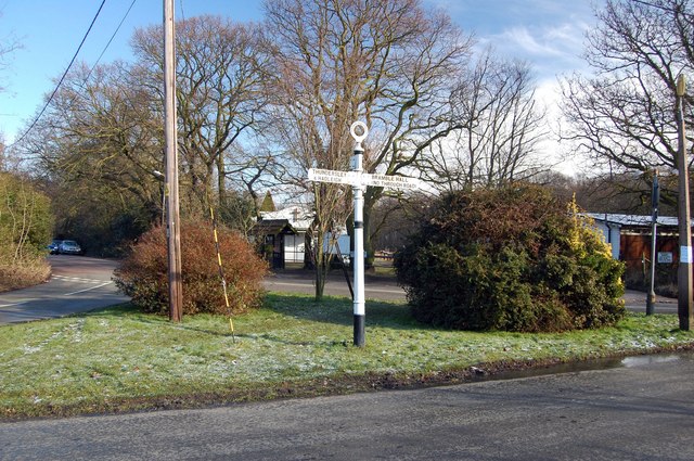
English: Old Signpost On the small green at the junction of Bramble Road (running across the photo) and Saint Michael's Road, stands this old finger post indicating Bramble Hall to the right, and Thundersley and Hadleigh to the left. The other "finger" which would have pointed down St Michael's Road and indicated Rayleigh must have been removed in the 1930's when the building of the A127 Southend Arterial Road blocked the route through. |
| Date | |
| Source | From geograph.org.uk |
| Author | Trevor Harris |
| Attribution (required by the license) | Trevor Harris / Old Signpost / |
| Camera location | | View this and other nearby images on: OpenStreetMap |
|---|
| Object location | | View this and other nearby images on: OpenStreetMap |
|---|
Licensing
[edit]
|
This image was taken from the Geograph project collection. See this photograph's page on the Geograph website for the photographer's contact details. The copyright on this image is owned by Trevor Harris and is licensed for reuse under the Creative Commons Attribution-ShareAlike 2.0 license.
|
This file is licensed under the Creative Commons Attribution-Share Alike 2.0 Generic license.
Attribution: Trevor Harris
- You are free:
- to share – to copy, distribute and transmit the work
- to remix – to adapt the work
- Under the following conditions:
- attribution – You must give appropriate credit, provide a link to the license, and indicate if changes were made. You may do so in any reasonable manner, but not in any way that suggests the licensor endorses you or your use.
- share alike – If you remix, transform, or build upon the material, you must distribute your contributions under the same or compatible license as the original.

_heading:45.00&language=en)
_heading:45.00&language=en)
File history
Click on a date/time to view the file as it appeared at that time.
| Date/Time | Thumbnail | Dimensions | User | Comment | |
|---|---|---|---|---|---|
| current | 10:56, 25 February 2011 | | 640 × 425 (112 KB) | GeographBot (talk | contribs) | == {{int:filedesc}} == {{Information |description={{en|1=Old Signpost On the small green at the junction of Bramble Road (running across the photo) and Saint Michael's Road, stands this old finger post indicating Bramble Hall to the right, and Thundersley |
You cannot overwrite this file.
File usage on Commons
There are no pages that use this file.