File:OHMap-doton-Blue Ball.png
Jump to navigation
Jump to search
No higher resolution available.
OHMap-doton-Blue_Ball.png (309 × 352 pixels, file size: 17 KB, MIME type: image/png)
Captions
Captions
Add a one-line explanation of what this file represents
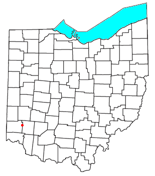
| Description | Locator map of the unincorporated community of Blue Ball in Butler and Warren Counties in the U.S. state of Ohio. | ||
| Date | |||
| Source | Modified from this United States Census Bureau file. | ||
| Author | User:Nyttend | ||
| Permission (Reusing this file) |
US Government work is public domain, and my work is
|
File history
Click on a date/time to view the file as it appeared at that time.
| Date/Time | Thumbnail | Dimensions | User | Comment | |
|---|---|---|---|---|---|
| current | 18:44, 8 October 2007 | | 309 × 352 (17 KB) | Nyttend (talk | contribs) | {{Information |Description=Locator map of the {{w|unincorporated area|unincorporated community}} of {{w|Collins, Ohio|Collins}} in {{w|Butler County, Ohio|Butler}} and {{w|Warren County, Ohio|Warren}} Counties in the {{w|U.S. state}} of {{w|Ohio}}. |Sourc |
You cannot overwrite this file.
File usage on Commons
There are no pages that use this file.
File usage on other wikis
The following other wikis use this file:
- Usage on en.wikipedia.org