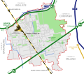
File:Novate Milanese - mappa trasporti.svg

Original file (SVG file, nominally 1,133 × 991 pixels, file size: 118 KB)
Captions
Captions
Summary
[edit]| DescriptionNovate Milanese - mappa trasporti.svg |
Italiano: Mappa di Novate Milanese, indicante le infrastrutture stradali, ferroviarie, le aree verdi e i confini amministrativi del comune |
||||
| Date | |||||
| Source | Own work based on some OpenStreetMap dats (openstreetmap.org). | ||||
| Author |
|
||||
| Permission (Reusing this file) |
|
||||
| Other versions |
|

|
This map is for illustrative purposes only and may be approximate, incomplete, inaccurate or out of date.
Warning: Don't rely solely on this map for navigation. |
This map was improved or created by the Wikigraphists of the Graphic Lab (it). You can propose images to clean up, improve, create or translate as well. |
File history
Click on a date/time to view the file as it appeared at that time.
| Date/Time | Thumbnail | Dimensions | User | Comment | |
|---|---|---|---|---|---|
| current | 12:10, 17 February 2024 |  | 1,133 × 991 (118 KB) | Arrow303 (talk | contribs) | white background + minor edits |
| 22:18, 10 February 2024 |  | 1,134 × 992 (118 KB) | Arrow303 (talk | contribs) | small fix | |
| 22:16, 10 February 2024 |  | 1,134 × 992 (116 KB) | Arrow303 (talk | contribs) | {{Information |Description={{it|Mappa di Novate Milanese, indicante le infrastrutture stradali, ferroviarie, le aree verdi e i confini amministrativi del comune}} |Source={{Own}} based on some OpenStreetMap datas (openstreetmap.org). |Date=2024-02-10 |Author= *'''OpenStreetMap datas:''' OpenStreetMap contributors *{{author|derivative|{{u|Arrow303}}}} |Permission={{self|ODbL OpenStreetMap}} |other_versions= }} {{Laboratorio grafico mappa}} Category:Novate Milanese |
You cannot overwrite this file.
File usage on Commons
The following 3 pages use this file:
File usage on other wikis
The following other wikis use this file:
- Usage on it.wikipedia.org
Metadata
This file contains additional information such as Exif metadata which may have been added by the digital camera, scanner, or software program used to create or digitize it. If the file has been modified from its original state, some details such as the timestamp may not fully reflect those of the original file. The timestamp is only as accurate as the clock in the camera, and it may be completely wrong.
| Width | 1132.9004 |
|---|---|
| Height | 991.2879 |
