File:Nova Svecia - Th. Companius Holm fecit. NYPL433864.tiff
Jump to navigation
Jump to search

Size of this JPG preview of this TIF file: 799 × 309 pixels. Other resolutions: 320 × 124 pixels | 640 × 248 pixels | 1,024 × 396 pixels | 1,280 × 495 pixels | 2,560 × 990 pixels | 7,218 × 2,792 pixels.
Original file (7,218 × 2,792 pixels, file size: 57.66 MB, MIME type: image/tiff)
Captions
Captions
Add a one-line explanation of what this file represents
Summary
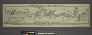
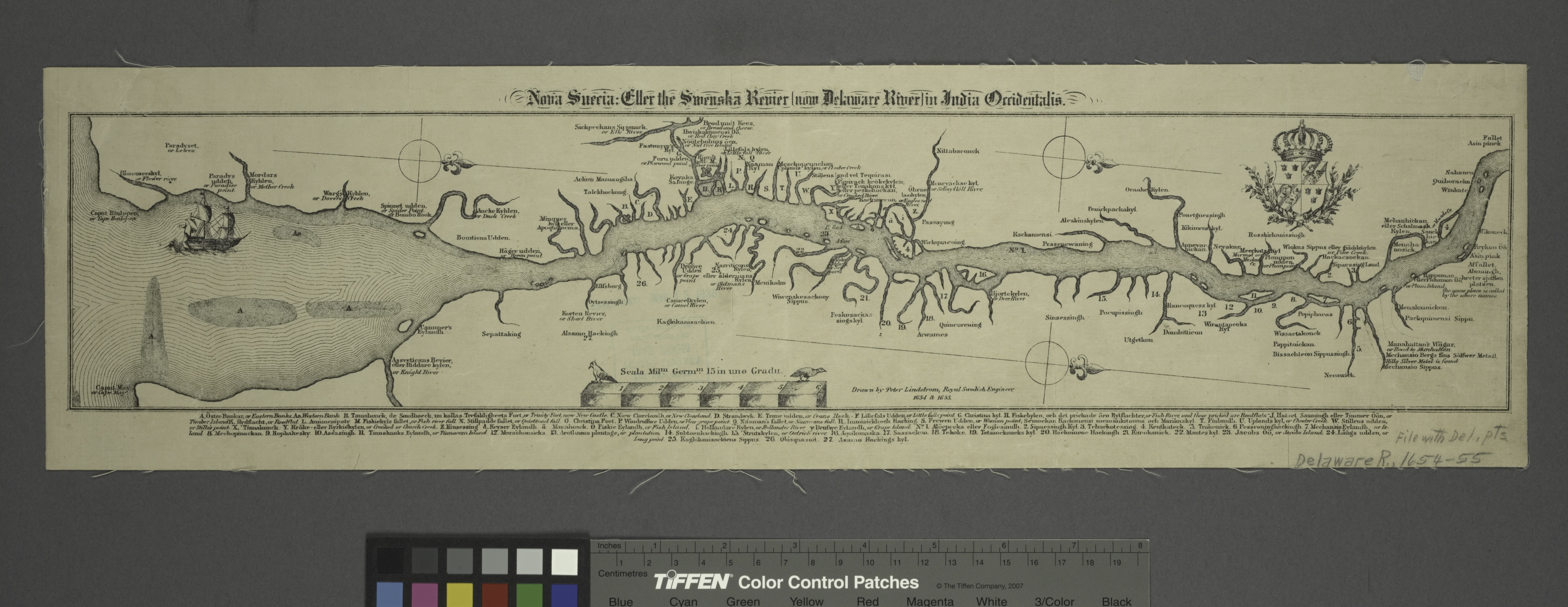
[edit]| Description | Nova Svecia / Th. Companius Holm fecit.; Lawrence H. Slaughter Collection of English maps, charts, globes, books and atlases / Atlases / Lutheri Catechismus / ofwersatt på American-Virginiske språket. | |||||||||||||||||||||||
| Notes | "Anno 1654 och 1655, Dr denna Novae Sveciae carta med dess riviers och landz situation ock beskaffenhet aftagen och till carts fvrd af P. Lindstrvm, ingin fortif." ''Note 2.'') "Anno 1654 och 1655, Dr denna Novae Sveciae carta med dess riviers och landz situation ock beskaffenhet aftagen och till carts fvrd af P. Lindstrvm, ingin fortif." ''Note 3.'') "Anno 1654 och 1655, Dr denna Novae Sveciae carta med dess riviers och landz situation ock beskaffenhet aftagen och till carts fvrd af P. Lindstrvm, ingin fortif." ''Note 4.'') "Anno 1654 och 1655, Dr denna Novae Sveciae carta med dess riviers och landz situation ock beskaffenhet aftagen och till carts fvrd af P. Lindstrvm, ingin fortif." ''Note 5.'') "Anno 1654 och 1655, Dr denna Novae Sveciae carta med dess riviers och landz situation ock beskaffenhet aftagen och till carts fvrd af P. Lindstrvm, ingin fortif." ''Note 6.'') "Anno 1654 och 1655, Dr denna Novae Sveciae carta med dess riviers och landz situation ock beskaffenhet aftagen och till carts fvrd af P. Lindstrvm, ingin fortif." ''Note 7.'') "N" in Nova of title printed backwards. ''Note 8.'') Includes ill., and coat of arms. ''Note 9.'') Lawrence H. Slaughter Collection ; 181. ''Note 10.'') Oriented with north to the lower right. ''Note 11.'') Shows the Swedish settlements on the Delaware River. | |||||||||||||||||||||||
| Catalogue call number | Map Div. 97-6229 (Map [1], frontispiece) [In LHS 3053] | |||||||||||||||||||||||
| Item physical description | 1 map ; 27 x 12 cm. folded to 17 x 9 cm. | |||||||||||||||||||||||
| Standard reference | Pilling: Algonquian languages, p. 65 | |||||||||||||||||||||||
| Date | ||||||||||||||||||||||||
| Source |
http://digitalgallery.nypl.org/nypldigital/dgkeysearchdetail.cfm?imageID=433864
|
|||||||||||||||||||||||
| Author | ||||||||||||||||||||||||
| Permission (Reusing this file) |
From The Lionel Pincus and Princess Firyal Map Division. http://maps.nypl.org
|
|||||||||||||||||||||||
| Source description | 9 p. l., 160 p. 17.5 cm. | |||||||||||||||||||||||
| Location | Stephen A. Schwarzman Building / The Lionel Pincus and Princess Firyal Map Division | |||||||||||||||||||||||
| Digital item published | 2-3-2004; updated 1-9-2012 | |||||||||||||||||||||||
| Digital ID | 433864 | |||||||||||||||||||||||

The making of this file was supported by Wikimedia UK.
To see other files made with the support of Wikimedia UK, please see the category Supported by Wikimedia UK.
|
File history
Click on a date/time to view the file as it appeared at that time.
| Date/Time | Thumbnail | Dimensions | User | Comment | |
|---|---|---|---|---|---|
| current | 20:54, 2 May 2014 | 7,218 × 2,792 (57.66 MB) | Fæ (talk | contribs) | GWToolset:: Creating mediafile for Fæ. Tranche 3 11591-16518 @ 2 May, 06:47 BST |
You cannot overwrite this file.
File usage on Commons
There are no pages that use this file.