File:Noua et accurata totius Americae tabula (2676130268).jpg
Jump to navigation
Jump to search
Size of this preview: 750 × 600 pixels. Other resolutions: 300 × 240 pixels | 600 × 480 pixels | 960 × 768 pixels | 1,280 × 1,024 pixels | 2,000 × 1,600 pixels.
Original file (2,000 × 1,600 pixels, file size: 3.27 MB, MIME type: image/jpeg)
Captions
Captions
Add a one-line explanation of what this file represents
Summary
[edit].jpg&action=edit§ion=1)
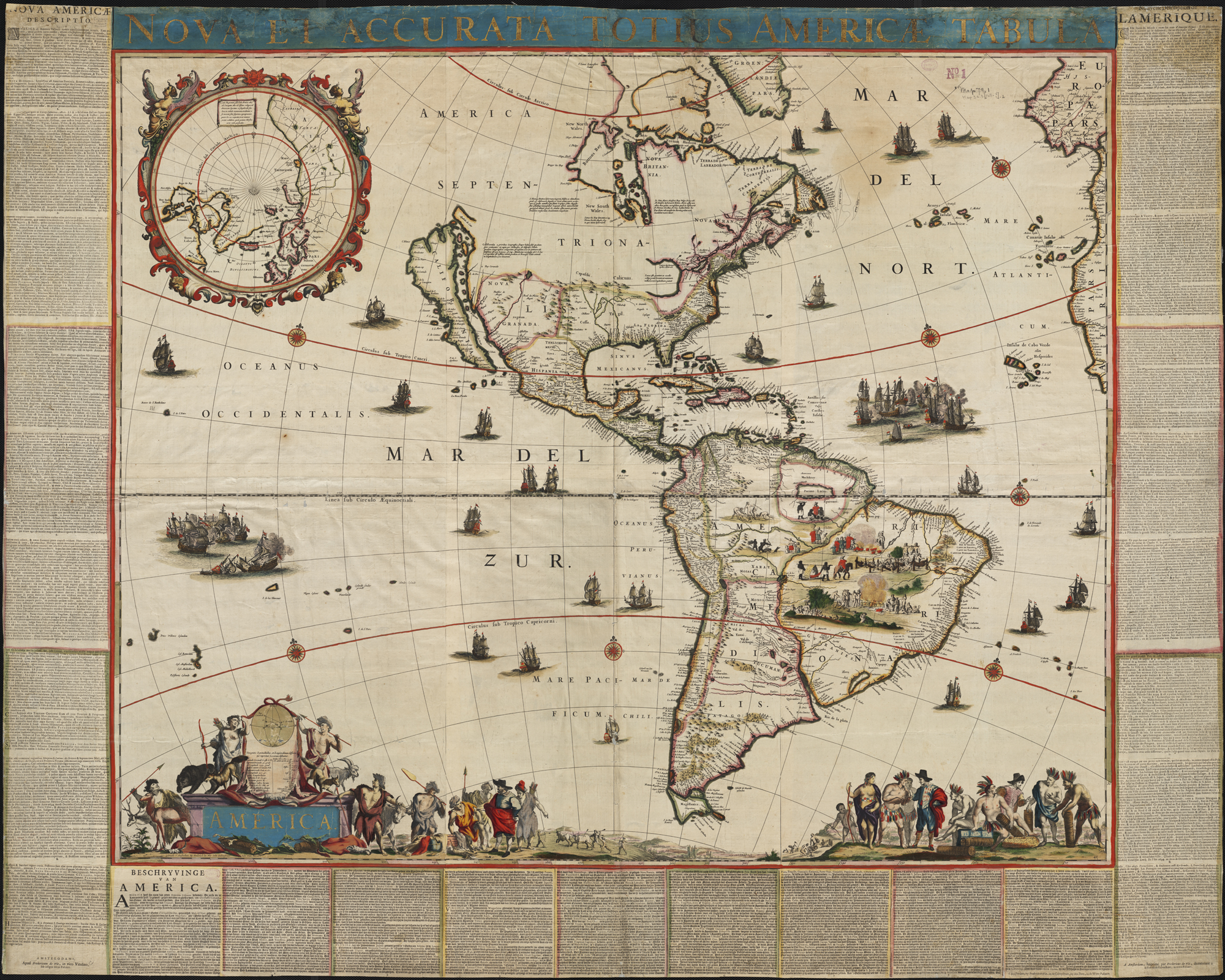
| Frederik de Wit: Noua et accurata totius Americae tabula
( |
||||||||||||||||||||||||||
|---|---|---|---|---|---|---|---|---|---|---|---|---|---|---|---|---|---|---|---|---|---|---|---|---|---|---|
| Artist |
|
|||||||||||||||||||||||||
| Title |
Noua et accurata totius Americae tabula |
|||||||||||||||||||||||||
| Description |
English: Zoom into this map at maps.bpl.org.
Location: America Call Number: G3290 1660.W5 Published by the noted mid-17th century Dutch cartographer, Frederick de Wit, this remarkably well preserved wall map of the Americas is previously unrecorded. With its large and masterful design, it is beautifully engraved and embellished, highlighted by the best Dutch coloring of the period. Early Dutch wall maps, perhaps the most decorative printed maps ever produced, are relatively uncommon today, primarily because their large size and public display lead to extensive damage and fading. According to the map's title, it presents a "new" and "accurate" geographic image of both Americas. However, its depiction of the North American west coast appears unfamiliar and inaccurate to modern eyes. This portrayal of California as an island was a long-held cartographic myth, based on incomplete and mistaken information that had gained wide acceptance among British and Dutch cartographers since the 1630s.Nederlands: 6 bladige wandkaart + txt |
|||||||||||||||||||||||||
| Date | 1660 | |||||||||||||||||||||||||
| Source/Photographer |
http://maps.bpl.org Noua et accurata totius Americae tabula
|
|||||||||||||||||||||||||
| Other versions |
 |
|||||||||||||||||||||||||
Licensing
[edit].jpg&action=edit§ion=2)
|
This is a faithful photographic reproduction of a two-dimensional, public domain work of art. The work of art itself is in the public domain for the following reason:
The official position taken by the Wikimedia Foundation is that "faithful reproductions of two-dimensional public domain works of art are public domain".
This photographic reproduction is therefore also considered to be in the public domain in the United States. In other jurisdictions, re-use of this content may be restricted; see Reuse of PD-Art photographs for details. | ||||
| This image, originally posted to Flickr, was reviewed on 21 August 2013 by the administrator or reviewer File Upload Bot (Magnus Manske), who confirmed that it was available on Flickr under the stated license on that date. |
File history
Click on a date/time to view the file as it appeared at that time.
| Date/Time | Thumbnail | Dimensions | User | Comment | |
|---|---|---|---|---|---|
| current | 04:31, 21 August 2013 | | 2,000 × 1,600 (3.27 MB) | File Upload Bot (Magnus Manske) (talk | contribs) | Transferred from Flickr by User:tm |
You cannot overwrite this file.
File usage on Commons
The following page uses this file:
.jpg)
.jpg&oldid=741433506)