File:North America, East Coast. Sheet I, Bay of Fundy (IA McGillLibrary-rbsc map bayfield-118-19295).pdf
Jump to navigation
Jump to search

Size of this JPG preview of this PDF file: 401 × 600 pixels. Other resolutions: 160 × 240 pixels | 321 × 480 pixels | 513 × 768 pixels | 684 × 1,024 pixels | 1,369 × 2,048 pixels | 2,677 × 4,004 pixels.
Original file (2,677 × 4,004 pixels, file size: 60.15 MB, MIME type: application/pdf)
Captions
Captions
Add a one-line explanation of what this file represents
Summary
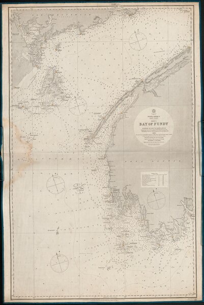
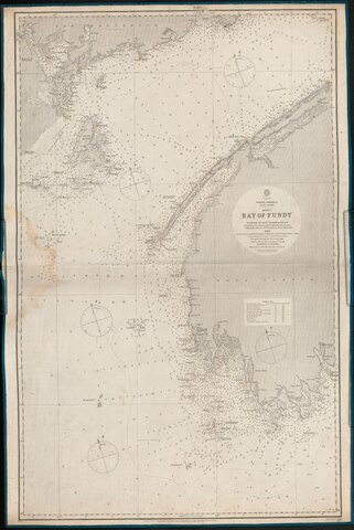
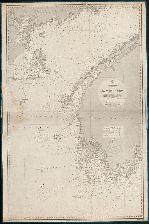
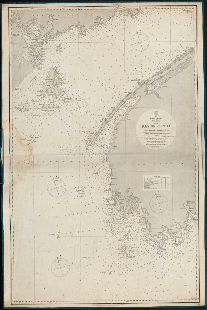
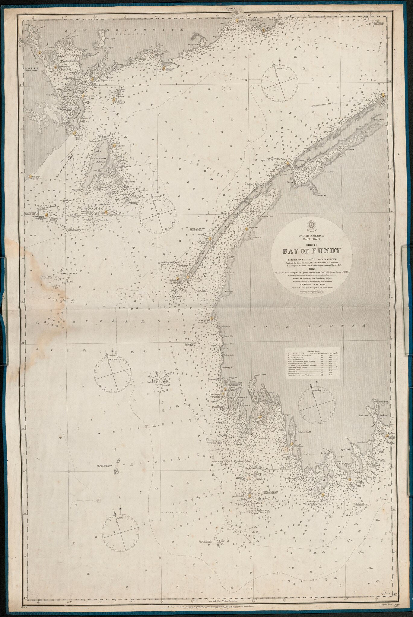
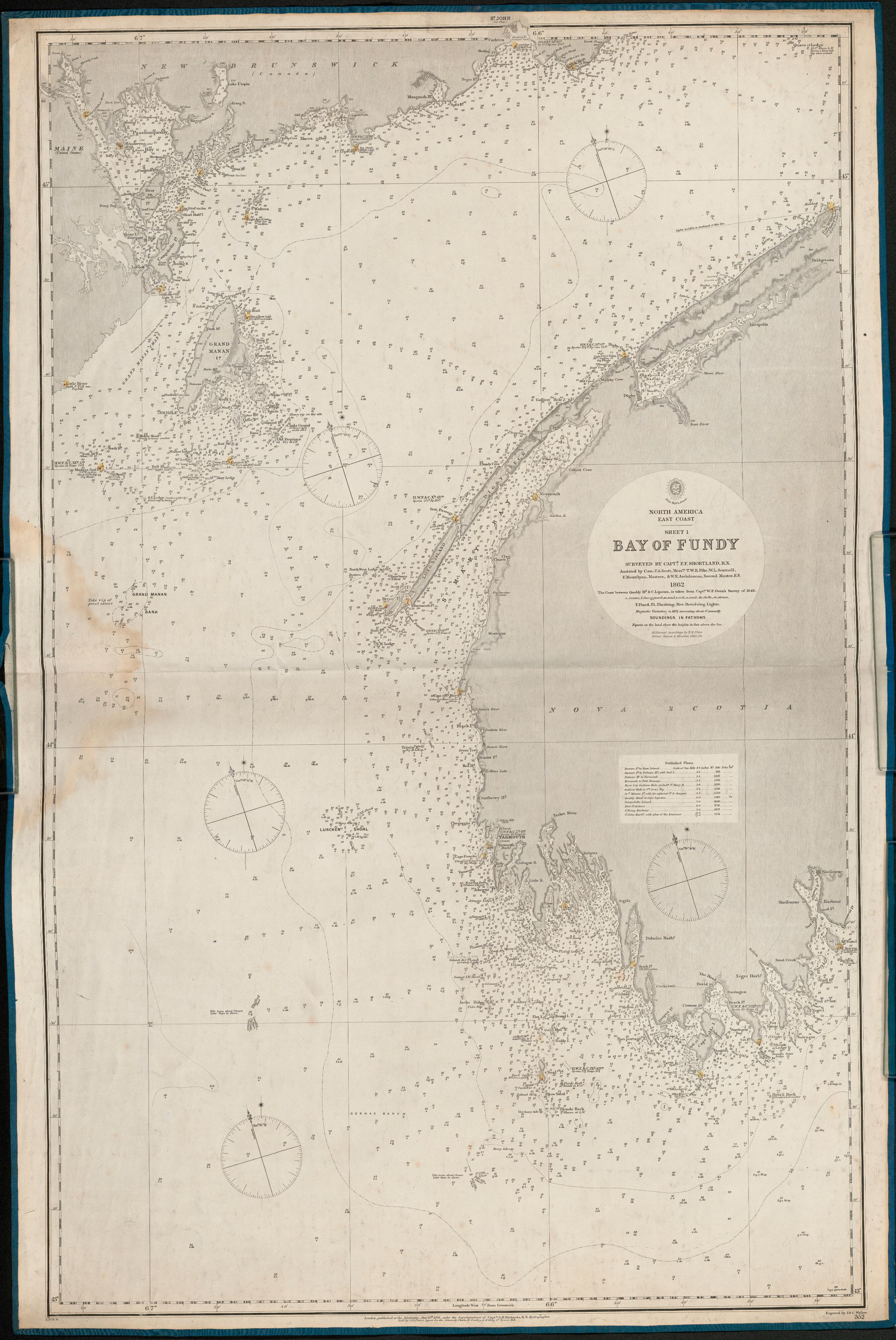
[edit]| North America, East Coast. Sheet I, Bay of Fundy
( |
|
|---|---|
| Author |
Great Britain. Hydrographic Office, issuing body |
| Title |
North America, East Coast. Sheet I, Bay of Fundy |
| Publisher |
London : Published at the Admiralty |
| Description |
Subjects: Nova Scotia -- Navigation -- Maps.; Fundy, Bay of -- Navigation -- Maps.; New Brunswick -- Navigation -- Maps.; Maine -- Navigation -- Maps.; Nautical charts -- Nova Scotia.; Nautical charts -- New Brunswick.; Nautical charts -- Maine.; Nautical charts -- Fundy, Bay of.; Canada -- Maps.; McGill University Library Digitized Title; Bayfield Project; Nautical charts -- Nova Scotia; Nautical charts -- New Brunswick; Nautical charts -- Maine; Nautical charts -- Fundy, Bay of; Nautical charts; Nova Scotia -- Navigation -- Maps; Fundy, Bay of -- Navigation -- Maps; New Brunswick -- Navigation -- Maps; Maine -- Navigation -- Maps; Canada -- Maps; Atlantic Ocean -- Bay of Fundy; Canada; Maine; New Brunswick; Nova Scotia |
| Language | English |
| Publication date | 1865 |
| Current location |
IA Collections: mcgilluniversity; mcgilluniversityrarebooks; toronto |
| Accession number |
McGillLibrary-rbsc_map_bayfield-118-19295 |
| Source |
|
Licensing
[edit]|
This work is in the public domain in its country of origin and other countries and areas where the copyright term is the author's life plus 100 years or fewer. This work is in the public domain in the United States because it was published (or registered with the U.S. Copyright Office) before January 1, 1929. | |
| This file has been identified as being free of known restrictions under copyright law, including all related and neighboring rights. | |
File history
Click on a date/time to view the file as it appeared at that time.
| Date/Time | Thumbnail | Dimensions | User | Comment | |
|---|---|---|---|---|---|
| current | 18:16, 1 January 2021 |  | 2,677 × 4,004 (60.15 MB) | Fæ (talk | contribs) | IA Query "subject:maps date:[1000 TO 1869] " McGillLibrary-rbsc_map_bayfield-118-19295 Category:Old maps (COM:IA books#query) (1865 #321) |
You cannot overwrite this file.
File usage on Commons
The following page uses this file: