File:New map of the states of Georgia South and North Carolina Virginia and Maryland - including the Spanish provinces of West and East Florida from the latest surveys - Cornelius Tieboout, sculp. NYPL434467.tiff
Jump to navigation
Jump to search

Size of this JPG preview of this TIF file: 500 × 599 pixels. Other resolutions: 200 × 240 pixels | 400 × 480 pixels | 641 × 768 pixels | 854 × 1,024 pixels | 1,709 × 2,048 pixels | 4,528 × 5,427 pixels.
Original file (4,528 × 5,427 pixels, file size: 70.31 MB, MIME type: image/tiff)
Captions
Captions
Add a one-line explanation of what this file represents
Summary
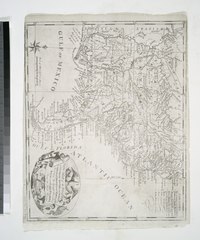
[edit]| Description | New map of the states of Georgia South and North Carolina Virginia and Maryland : including the Spanish provinces of West and East Florida from the latest surveys / Cornelius Tieboout, sculp. N. York.; Lawrence H. Slaughter Collection of English maps, charts, globes, books and atlases / Charts and maps | |||||||||||||||||||||||
| Notes | From William Gordon's History of the rise, progress, and establishment of the independence of the United States of America. ''Note 2.'') Includes decorative cartouche. ''Note 3.'') Lawrence H. Slaughter Collection ; 418. ''Note 4.'') National Endowment for the Humanities Grant for Access to Early Maps of the Middle Atlantic Seaboard. ''Note 5.'') Prime meridians: Philadelphia and London. ''Note 6.'') Relief shown pictorially. ''Note 7.'') Shows forts and native Indian villages. | |||||||||||||||||||||||
| Item physical description | 1 map ; 30 x 36 cm. | |||||||||||||||||||||||
| Catalogue call number | Map Div. 97-6329 [LHS 418] | |||||||||||||||||||||||
| Standard reference | Phillips. Maps of America, p. 296; Wheat and Brun. Maps and charts published in America before 1800, 492 | |||||||||||||||||||||||
| Date | ||||||||||||||||||||||||
| Source |
http://digitalgallery.nypl.org/nypldigital/dgkeysearchdetail.cfm?imageID=434467
|
|||||||||||||||||||||||
| Author | Cornelius, 1777-1830 -- Engraver Tiebout | |||||||||||||||||||||||
| Permission (Reusing this file) |
From The Lionel Pincus and Princess Firyal Map Division. http://maps.nypl.org
|
|||||||||||||||||||||||
| Location | Stephen A. Schwarzman Building / The Lionel Pincus and Princess Firyal Map Division | |||||||||||||||||||||||
| Digital item published | 2-3-2004; updated 3-25-2011 | |||||||||||||||||||||||
| Digital ID | 434467 | |||||||||||||||||||||||

The making of this file was supported by Wikimedia UK.
To see other files made with the support of Wikimedia UK, please see the category Supported by Wikimedia UK.
|
File history
Click on a date/time to view the file as it appeared at that time.
| Date/Time | Thumbnail | Dimensions | User | Comment | |
|---|---|---|---|---|---|
| current | 07:57, 2 May 2014 |  | 4,528 × 5,427 (70.31 MB) | Fæ (talk | contribs) | GWToolset:: Creating mediafile for Fæ. Tranche 3 11591-16518 @ 2 May, 06:47 BST |
You cannot overwrite this file.
File usage on Commons
There are no pages that use this file.