File:Nevada TTR Chart.jpg
Jump to navigation
Jump to search

Size of this preview: 755 × 600 pixels. Other resolutions: 302 × 240 pixels | 604 × 480 pixels | 967 × 768 pixels | 1,280 × 1,017 pixels | 2,560 × 2,034 pixels | 4,997 × 3,970 pixels.
Original file (4,997 × 3,970 pixels, file size: 23.09 MB, MIME type: image/jpeg)
Captions
Captions
Add a one-line explanation of what this file represents
Summary
[edit]

|
This file was moved to Wikimedia Commons from en.wikipedia using a bot script. All source information is still present. It requires review. Additionally, there may be errors in any or all of the information fields; information on this file should not be considered reliable and the file should not be used until it has been reviewed and any needed corrections have been made. Once the review has been completed, this template should be removed. For details about this file, see below. Check now! |
| Description |
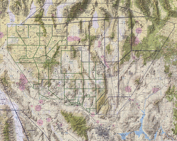
English: The five geographical areas of the Nellis Range Complex consist of: Restricted Areas R-4806, primarily used for testing and munitions training; R-4807, used for electronic combat and munitions training; R-4808, used by the Nevada Test Site; R-4809, used primarily as an electronic combat range; and the Desert Military Operating Area, used for air-to-air training. The Nellis Range Complex is located between Las Vegas and Tonopah in Southwestern Nevada and consists of five adjacent geographical areas. The ground is mostly barren, consisting mainly of flat, dry lake beds, dry washes, desert vegetation, and rugged, mountainous terrain. The land occupied by the NRC is more than , combined with more than of airspace. The 99th Range Squadron, which controls the range, is located on Nellis Air Force Base, approximately northeast of Las Vegas.The NAFR consists of approximately . The majority of the NAFR consists of lands withdrawn from the BLM. Withdrawn lands refers to land which is set aside for a specific use. In this case, it is land that has been set aside for military use that is not available for public use. It remains under the jurisdiction and management of the agency that is responsible for the land. The Air Force must comply with all uses, policies, programs, federal requirements as mandated and administered through BLM. The Nevada Wild Horse Range is included in the NAFR and is administered by the BLM. Approximately of the NAFR have been withdrawn from the Desert National Wildlife Range (DNWR). The Air Force and USFWS jointly manage this area. The Nevada Test Site, administered by the DOE, is contiguous with the NAFR in the southwestern part of the NRC. Public access to the NAFR and the Nevada Test Site is highly restricted, although some areas support grazing leases. The NAFR is used for training, testing, and weapons evaluation operations for the Air Force, Army, Marine Corps, National Guard, Navy, DOE, and reserve forces. Target complexes with bombing circles and triangles, and simulated runways, airfields, and convoys are situated on parts of the NAFR. |
| Date | (UTC) |
| Source | NGSIA |
| Author | NGSIA |
Licensing
[edit]
This work is in the public domain in the United States because it is a work prepared by an officer or employee of the United States Government as part of that person’s official duties under the terms of Title 17, Chapter 1, Section 105 of the US Code.
Note: This only applies to original works of the Federal Government and not to the work of any individual U.S. state, territory, commonwealth, county, municipality, or any other subdivision. This template also does not apply to postage stamp designs published by the United States Postal Service since 1978. (See § 313.6(C)(1) of Compendium of U.S. Copyright Office Practices). It also does not apply to certain US coins; see The US Mint Terms of Use.
|
 | |
| This file has been identified as being free of known restrictions under copyright law, including all related and neighboring rights. | ||
Original upload log
[edit]
Transferred from en.wikipedia to Commons by Fredlyfish4 using CommonsHelper.
The original description page was here. All following user names refer to en.wikipedia.
- 2010-06-14 00:50 Flakeyswilson 4997×3970× (24210244 bytes) {{Information |Description = |Source = |Date = ~~~~~ |Author = |Permission = |other_versions = }}
File history
Click on a date/time to view the file as it appeared at that time.
| Date/Time | Thumbnail | Dimensions | User | Comment | |
|---|---|---|---|---|---|
| current | 21:31, 10 February 2013 | | 4,997 × 3,970 (23.09 MB) | File Upload Bot (Magnus Manske) (talk | contribs) | Transfered from en.wikipedia by User:Fredlyfish4 using CommonsHelper |
You cannot overwrite this file.
File usage on Commons
There are no pages that use this file.
File usage on other wikis
The following other wikis use this file:
- Usage on sv.wikipedia.org