File:Netzentwuerfe.png
Jump to navigation
Jump to search

Size of this preview: 221 × 599 pixels. Other resolutions: 88 × 240 pixels | 177 × 480 pixels | 797 × 2,161 pixels.
Original file (797 × 2,161 pixels, file size: 242 KB, MIME type: image/png)
Captions
Captions
Add a one-line explanation of what this file represents
Summary
[edit]| Description |
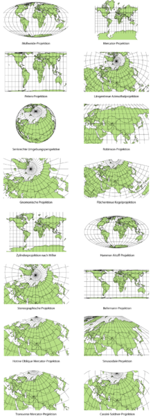
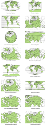
Deutsch: Vergleichende Darstellung ausgewählter Kartenprojektionsarten.
Die runde Erde auf einem flachen Stück Papier abzubilden ist seit Anfang an mit die größte Herausforderung der Kartographie. Auf welch vielfältige Weise diese bewältigt werden kann, wird in dieser vergleichenden Übersicht der unterschiedlichen Kartenprojektionsarten vor Augen geführt. Erstellt wurde die Darstellung mit der MapTools-Extension von ESRI ArcView, die dann einer Überarbeitung in Adobe Illustrator unterzogen wurde. |
| Date | 8 July 2006 (original upload date) |
| Source | Own work |
| Author | Maximilian Dörrbecker |
- Single images
-

-

-

-
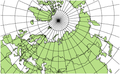
 Längentreue Azimutal-Projektion
 -
 Senkrechte Umgebungsperspektive
 -

-

-
 Flächentreue Kegelprojektion
 -
 Zylinderprojektion nach Miller
 -

-
-
 Behrmann-Projektion
 -
 Hotine Oblique Mercator-Projektion
 -

-
 Transverse Mercator-Projektion
 -
 Cassini-Soldner-Projektion


|
This map image could be re-created using vector graphics as an SVG file. This has several advantages; see Commons:Media for cleanup for more information. If an SVG form of this image is available, please upload it and afterwards replace this template with
{{vector version available|new image name}}.
It is recommended to name the SVG file “Netzentwuerfe.svg”—then the template Vector version available (or Vva) does not need the new image name parameter. |
Licensing
[edit]

|
Permission is granted to copy, distribute and/or modify this document under the terms of the GNU Free Documentation License, Version 1.2 or any later version published by the Free Software Foundation; with no Invariant Sections, no Front-Cover Texts, and no Back-Cover Texts. A copy of the license is included in the section entitled GNU Free Documentation License. |
| This file is licensed under the Creative Commons Attribution-Share Alike 3.0 Unported license. | ||
| ||
| This licensing tag was added to this file as part of the GFDL licensing update. |
File history
Click on a date/time to view the file as it appeared at that time.
| Date/Time | Thumbnail | Dimensions | User | Comment | |
|---|---|---|---|---|---|
| current | 23:27, 13 February 2015 | 797 × 2,161 (242 KB) | RokerHRO (talk | contribs) | optipng -o7 -i0 → 63.11% decrease | |
| 05:18, 8 July 2006 | 797 × 2,161 (655 KB) | Chumwa (talk | contribs) | *'''Description:''' Vergleichende Darstellung ausgewählter Kartenprojektionsarten *'''Source:''' Maximilian Dörrbecker {{GFDL}} Category:KartenprojektionCategory:KarteCategory:Kartographie |
You cannot overwrite this file.
File usage on Commons
The following page uses this file:
File usage on other wikis
The following other wikis use this file:
- Usage on ast.wikipedia.org
- Usage on ca.wikipedia.org
- Usage on cs.wikipedia.org
- Usage on da.wikipedia.org
- Usage on de.wikipedia.org
- Kartennetzentwurf
- Benutzer:Chumwa
- Wikipedia:Archiv/Bilderwettbewerb/Kategorie Grafik
- Wikipedia:Archiv/Bilderwettbewerb/Zuschauerpreis
- Wikipedia:Pressemitteilungen/Bilderwettbewerb-Ende
- Benutzer:Chumwa/Bilderwettbewerb
- Wikipedia:Kandidaten für exzellente Bilder/Archiv2006/15
- Wikipedia Diskussion:Bilderwettbewerb/Archiv02
- Wikipedia:Archiv/Bilderwettbewerb/Archiv2006
- Benutzer:Wesn/todo
- Benutzer:Chumwa/SomeOfMyFiles
- Wikipedia:Auskunft/Archiv/2017/Woche 32
- Usage on es.wikipedia.org
- Usage on et.wikipedia.org
- Usage on eu.wikipedia.org
- Usage on gl.wikipedia.org
- Usage on hi.wikipedia.org