File:Netherlands, Zijl (4).jpg
Jump to navigation
Jump to search

Size of this preview: 458 × 600 pixels. Other resolutions: 183 × 240 pixels | 366 × 480 pixels | 586 × 768 pixels | 1,176 × 1,540 pixels.
Original file (1,176 × 1,540 pixels, file size: 1,014 KB, MIME type: image/jpeg)
Captions
Captions
Add a one-line explanation of what this file represents
Summary
[edit].jpg&action=edit§ion=1)
| Description |
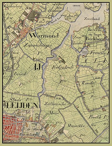
Nederlands: Dit deel van een kaart van Zuid-Holland uit 1850-1851 toont de rivier de Zijl bij Leiden, beginnend in het zuiden bij de Spanjaardsbrug en eindigend bij de monding in de Kager plas Zweiland. Van zuid naar noord liggen er twee eilanden in de rivier. Bij de verbetering van de Zijl in 1936-37 werd bij het zuidelijkste eiland (het Zijleiland, tegenover de Driegatenbrug) de hoofdstroom van de rivier verlegd van de westzijde naar de oostzijde van dit eiland. Het noordelijke eiland, halverwege de rivier gelegen, werd weggebaggerd. De naar het zuidoosten uitstekende punt van de Zwanenburgerpolder tenslotte, werd bij die werkzaamheden afgesneden. Daarbij ontstond het Boterhuiseiland. In de jaren 1970 werden vervolgens grote delen van de Zwan(en)burgerpolder afgegraven.
English: Part of a map of the Dutch Province of South Holland from 1851, showing the river Zijl, from Leiden to the Kagerplassen (Kaag lakes), Netherlands. |
| Date | between 1850 and 1851 |
| Source | http://www.gahetna.nl/collectie/afbeeldingen/kaartencollectie/zoeken/ |
| Author | Enderlein, H.J., Schuurman, J. |
The word "Zijl" on the map is located at:
| Camera location | | View this and other nearby images on: OpenStreetMap |
|---|
.jpg¶ms=052.191036_N_0004.527311_E_globe:Earth_type:camera_region:NL_&language=en)
Afkomstig van : Nationaal Archief (http://www.gahetna.nl). Topografische kaart van Den Haag en Leiden en omgeving; Nettekeningen 1:25.000 van de veldminuten ten behoeven van de Topografische Militaire Kaart, 1850-1864. Toegang 4.TOPO ; Inventarisnummer 8.30
Licensing
[edit].jpg&action=edit§ion=2)
|
This is a faithful photographic reproduction of a two-dimensional, public domain work of art. The work of art itself is in the public domain for the following reason:
The official position taken by the Wikimedia Foundation is that "faithful reproductions of two-dimensional public domain works of art are public domain". This photographic reproduction is therefore also considered to be in the public domain in the United States. In other jurisdictions, re-use of this content may be restricted; see Reuse of PD-Art photographs for details. {{PD-Art}} template without license parameter: please specify why the underlying work is public domain in both the source country and the United States
(Usage: {{PD-Art|1=|deathyear=''year of author's death''|country=''source country''}}, where parameter 1= can be PD-old-auto, PD-old-auto-expired, PD-old-auto-1996, PD-old-100 or similar. See Commons:Multi-license copyright tags for more information.) | ||||
File history
Click on a date/time to view the file as it appeared at that time.
| Date/Time | Thumbnail | Dimensions | User | Comment | |
|---|---|---|---|---|---|
| current | 20:09, 13 October 2011 | | 1,176 × 1,540 (1,014 KB) | Loranchet (talk | contribs) | {{Information |Description ={{nl|1=Dit deel van een kaart van Zuid-Holland uit 1850-1851 toont de rivier de Zijl bij Leiden, beginnend in het zuiden bij de Spanjaardsbrug en eindigend bij de monding in de Kager plas Zweiland. Van zuid naar noord liggen |
You cannot overwrite this file.
File usage on Commons
There are no pages that use this file.
File usage on other wikis
The following other wikis use this file:
- Usage on en.wikipedia.org
- Usage on nl.wikipedia.org
.jpg&oldid=858486868)