File:Natal, municípios limítrofes e região metropolitana.svg
Jump to navigation
Jump to search

Size of this PNG preview of this SVG file: 354 × 600 pixels. Other resolutions: 142 × 240 pixels | 283 × 480 pixels | 453 × 768 pixels | 604 × 1,024 pixels | 1,209 × 2,048 pixels | 620 × 1,050 pixels.
Original file (SVG file, nominally 620 × 1,050 pixels, file size: 19 KB)
Captions
Captions
Add a one-line explanation of what this file represents
| Description |
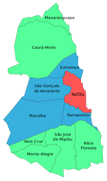
Português: Mapa mostrando os municípios da Região Metropolitana de Natal, com Natal em vermelho e seus municípios limítrofes em azul. |
|||
| Date | ||||
| Source |
File:Municípios da Região Metropolitana de Natal.svg, own work, This W3C-unspecified vector image was created with Inkscape . |
|||
| Author |
by Marcos Elias de Oliveira Júnior talk! + (contact here) |
|||
| Permission (Reusing this file) |
|
File history
Click on a date/time to view the file as it appeared at that time.
| Date/Time | Thumbnail | Dimensions | User | Comment | |
|---|---|---|---|---|---|
| current | 15:49, 22 February 2015 | | 620 × 1,050 (19 KB) | Marquinhos (talk | contribs) | Included Maxaranguape municipality. |
| 14:50, 7 October 2011 |  | 744 × 975 (16 KB) | Marquinhos (talk | contribs) | Correções: Nísia Floresta repetida duas vezes, e a cor de Parnamirim errada. | |
| 23:44, 13 August 2011 |  | 744 × 975 (16 KB) | Marquinhos (talk | contribs) | {{Information |Description ={{pt|1=Mapa mostrando os municípios da Região Metropolitana de Natal, com Natal em vermelho e seus municípios limítrofes em azul.}} |Source =File:Municípios da Região Metropolitana de Natal.svg, own work, |
You cannot overwrite this file.
File usage on Commons
There are no pages that use this file.