File:NPS lassen-volcanic-geologic-map.jpg
Jump to navigation
Jump to search

Size of this preview: 800 × 483 pixels. Other resolutions: 320 × 193 pixels | 640 × 386 pixels | 1,024 × 618 pixels | 1,280 × 772 pixels | 2,560 × 1,544 pixels | 4,661 × 2,812 pixels.
Original file (4,661 × 2,812 pixels, file size: 2.65 MB, MIME type: image/jpeg)
Captions
Captions
Add a one-line explanation of what this file represents
Summary
[edit]
| Description |
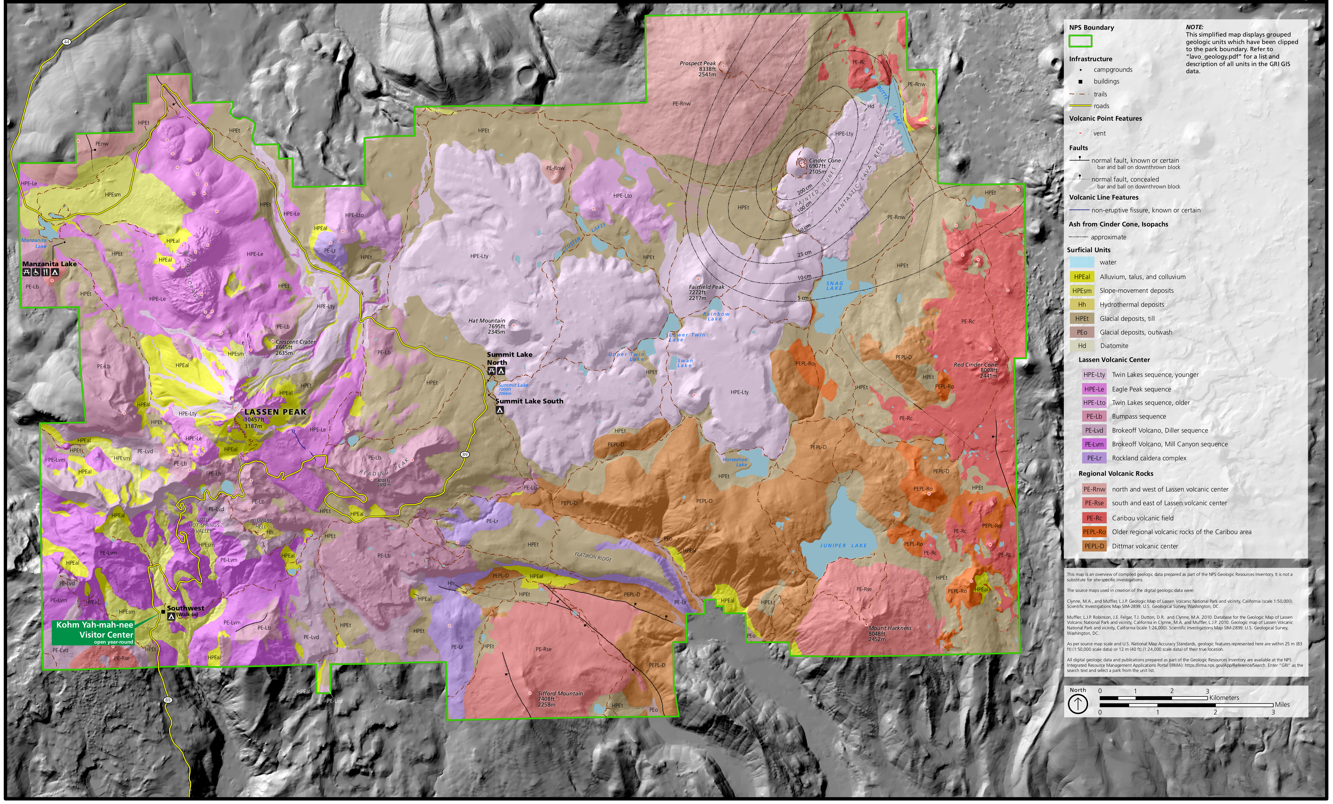
English: Lassen geologic map, showing both the recent volcanic surficial deposits as well as some of the older bedrock near Lassen Peak, overlaid on a shaded terrain view of the national park. |
| Date | |
| Source | U.S. National Park Service (http://npmaps.com/wp-content/uploads/lassen-volcanic-geologic-map.jpg) |
| Author | U.S. National Park Service, restoration/cleanup by Matt Holly |
Licensing
[edit]
| This image or media file contains material based on a work of a National Park Service employee, created as part of that person's official duties. As a work of the U.S. federal government, such work is in the public domain in the United States. See the NPS website and NPS copyright policy for more information. |
File history
Click on a date/time to view the file as it appeared at that time.
| Date/Time | Thumbnail | Dimensions | User | Comment | |
|---|---|---|---|---|---|
| current | 00:51, 17 May 2017 | | 4,661 × 2,812 (2.65 MB) | RKBot (talk | contribs) | =={{int:filedesc}}== {{Information |description= {{en|1=Lassen geologic map, showing both the recent volcanic surficial deposits as well as some of the older bedrock near Lassen Peak, overlaid on a shaded terrain view of the national park.}} |date= 201... |
You cannot overwrite this file.
File usage on Commons
There are no pages that use this file.
File usage on other wikis
The following other wikis use this file:
- Usage on he.wikipedia.org
- Usage on pt.wikipedia.org
- Usage on www.wikidata.org
Categories:
- Geological maps of Lassen Volcanic National Park
- Volcanological maps of California
- Holocene alluvium in California
- Holocene colluvium in California
- Holocene talus in California
- Holocene mass movement deposits in California
- Holocene hydrothermal deposits in California
- Holocene glacial deposits in California
- Holocene diatomite in California
- Pleistocene alluvium in California
- Pleistocene colluvium in California
- Pleistocene talus in California
- Pleistocene mass movement deposits in California
- Pleistocene glacial deposits in California
- Twin Lakes Sequence
- Eagle Peak Sequence
- Bumpass Sequence
- Brokeoff Volcano Diller Sequence
- Brokeoff Volcano, Mill Canyon Sequence
- Rockland Caldera complex
- Caribou Volcanic Center
- Dittmar Volcanic Center
- Fantastic Lava Beds
- Painted Dunes
- Cinder Cone (Lassen)
- Maps of Lassen volcano
- Chaos Crags
- Bumpass Hell
- Red Cinder Cone (Lassen)