File:NPS grand-canyon-classic-map.pdf
Jump to navigation
Jump to search

Size of this JPG preview of this PDF file: 800 × 522 pixels. Other resolutions: 320 × 209 pixels | 640 × 418 pixels | 1,024 × 668 pixels | 1,280 × 836 pixels | 2,183 × 1,425 pixels.
Original file (2,183 × 1,425 pixels, file size: 181 KB, MIME type: application/pdf)
Captions
Captions
Add a one-line explanation of what this file represents
Summary
[edit]| Description |
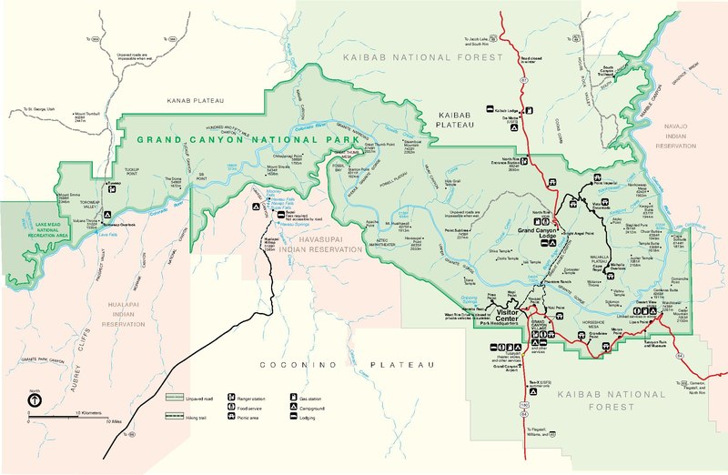
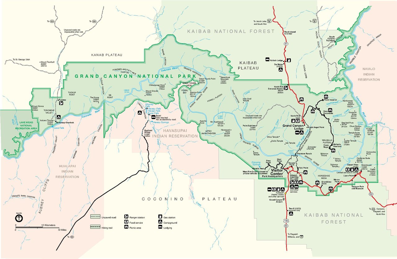
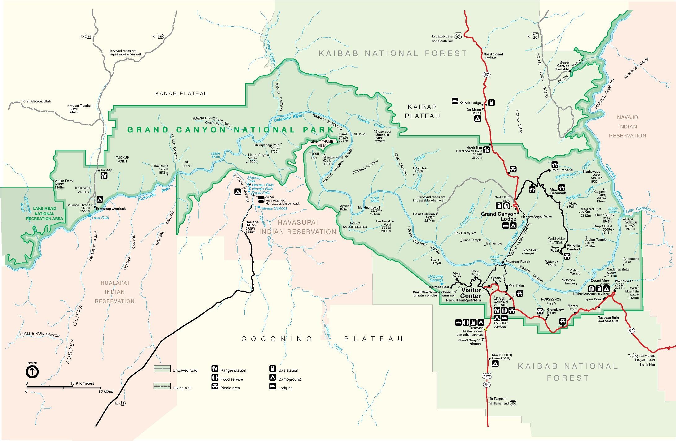
English: Are you old school? Here is the classic map of Grand Canyon National Park. It may not be pretty, but it is easy-to-read and print. |
| Date | |
| Source | U.S. National Park Service (http://npmaps.com/wp-content/uploads/grand-canyon-classic-map.pdf) |
| Author | U.S. National Park Service, restoration/cleanup by Matt Holly |
| Other versions |
 |
Licensing
[edit]| This image or media file contains material based on a work of a National Park Service employee, created as part of that person's official duties. As a work of the U.S. federal government, such work is in the public domain in the United States. See the NPS website and NPS copyright policy for more information. |
File history
Click on a date/time to view the file as it appeared at that time.
| Date/Time | Thumbnail | Dimensions | User | Comment | |
|---|---|---|---|---|---|
| current | 23:11, 16 May 2017 |  | 2,183 × 1,425 (181 KB) | RKBot (talk | contribs) | =={{int:filedesc}}== {{Information |description= {{en|1=Are you old school? Here is the classic map of Grand Canyon National Park. It may not be pretty, but it is easy-to-read and print.}} |date= 2013-10-24 |source= U.S. National Park Service (http://n... |
You cannot overwrite this file.
File usage on Commons
The following 2 pages use this file:
Metadata
Categories:
- Maps of Grand Canyon National Park
- Point Imperial (Grand Canyon)
- Nankoweap Canyon
- Nankoweap Creek
- Siegfried Pyre
- Kwagunt Butte
- Nankoweap Mesa
- Jupiter Temple
- Comanche Point
- Cardenas Butte
- Cedar Mountain (Desert View region, Grand Canyon)
- Mount Sinyella
- Powell Plateau
- Point Sublime
- Tuna Canyon
- Havasu Canyon
- Havasu Creek
- Diana Temple
- Great Thumb Mesa
- Upper Granite Gorge
- Granite Gorge