File:NOAA Satellites Monitor Wildfires (NESDIS 2024-08-01 2024 08 01 NOAA-Satellites-Monitor-Wildfires Park-Fire-NO TEXT).webm
Jump to navigation
Jump to search
Size of this JPG preview of this WEBM file: 800 × 450 pixels. Other resolutions: 320 × 180 pixels | 640 × 360 pixels | 1,024 × 576 pixels | 1,280 × 720 pixels | 2,560 × 1,440 pixels | 3,840 × 2,160 pixels.
Original file (WebM audio/video file, VP9/Opus, length 2 min 19 s, 3,840 × 2,160 pixels, 15.96 Mbps overall, file size: 264.35 MB)
Captions
Captions
Roughly 100 wildfires are raging out of control across the western United States and hundreds more are burning in Canada, destroying homes, forcing evacuations, and affecting air quality.
Summary
[edit]| Description |
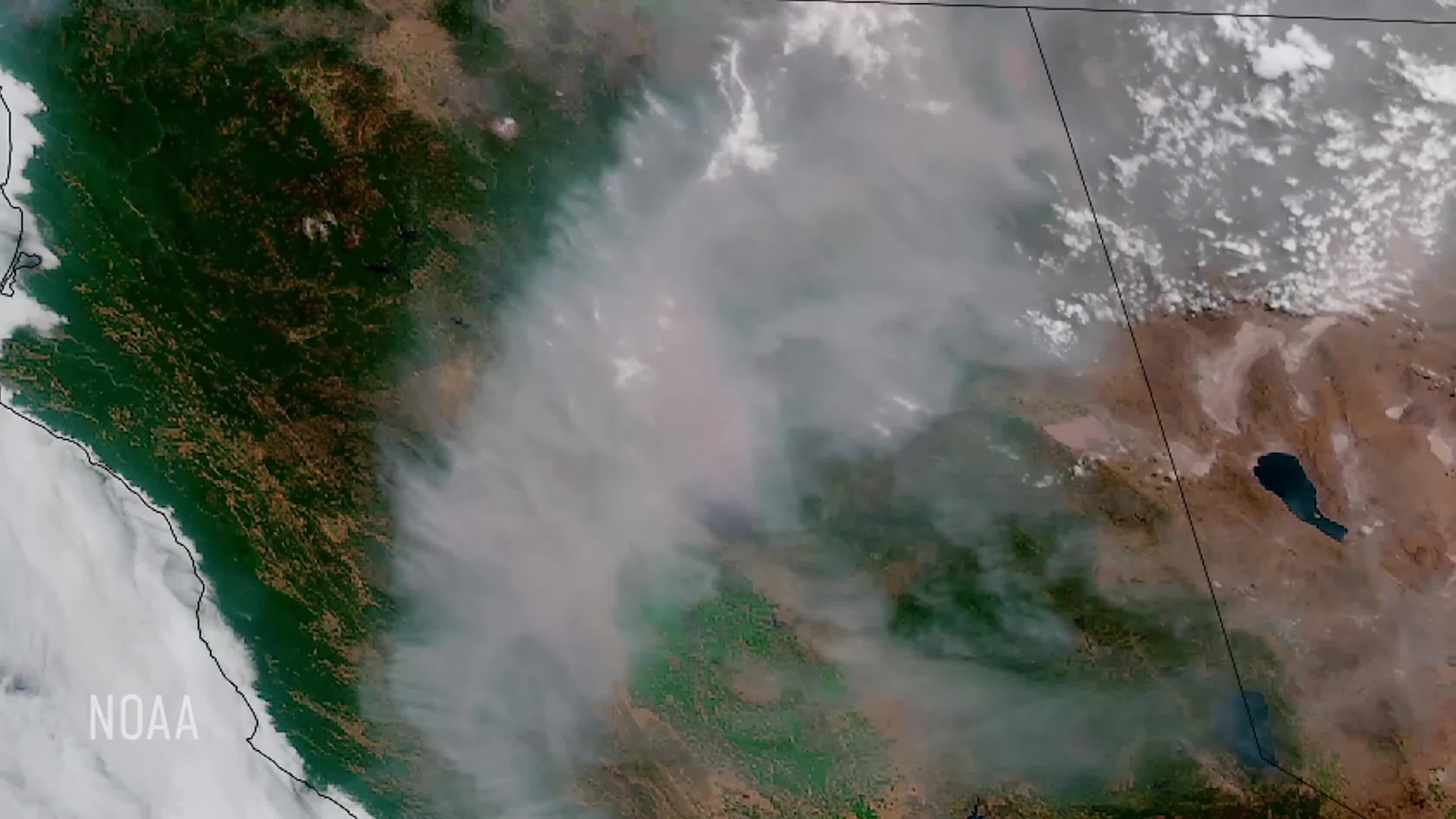
English: Roughly 100 wildfires are raging out of control across the western United States and hundreds more are burning in Canada, destroying homes, forcing evacuations, and affecting air quality. NOAA satellites have been closely monitoring these blazes, including California’s Park Fire, which is currently the largest active wildfire in the U.S. The Park Fire, which started on July 24, 2024, is believed to have been ignited by arson. A suspect has been arrested, accused of pushing a burning car into a gully, sparking the blaze. As of Aug. 1, the fire has consumed 392,480 acres across Butte, Plumas, Shasta, and Tehama counties. Fueled by very dry grass and brush, and driven by strong winds, the fire was only 18% contained. This fire has been compared to the catastrophic 2018 Camp Fire, and numerous evacuation warnings have been issued for the area. However, progress is being made in containing the fire’s southern front. Nearly 6000 firefighters, supported by helicopters and air tankers, are battling the rapidly spreading inferno. To date, the fire has destroyed more than 430 structures thus far. On July 26, NOAA’s GOES East satellite captured imagery of intense pyrocumulonimbus clouds—or fire-triggered thunderstorms—generated by the Park Fire. These form when intense heat causes hot air to rise, mixing gases and smoke particles. As water vapor condenses, a cumulus cloud forms from the smoke plume and releases energy. Sometimes lightning can be generated from these clouds, increasing the risk of starting more fires. Additionally, the fire appeared to produce a pair of counter-rotating vortices, or pillars of smoke, based on ALERT Wildfire camera footage and radar data. In Southern California, The Borel Fire has consumed more than 59,000 acres and prompted the evacuation of thousands of residents from the Sequoia National Forest. Driven by strong winds and dry conditions, this fire has severely impacted the historic mining town of Havilah and nearby communities. Meanwhile, the Durkee Fire in Oregon, is the largest in the state at more than 293,882 acres. Believed to have been started by lightning, the fire was 58% contained as of Aug. 1. In Canada, a massive wildfire in Jasper National Park, Alberta, has destroyed a third of the tourist town of Jasper and is expected to burn for months. The fire, which started a week ago on the hottest day ever recorded on Earth, has scorched nearly 80,000 acres. Park officials said this wildfire is the largest in the Park in 100 years, and that half of Jasper’s buildings were destroyed. In all, there are currently 115 active wildfires in Alberta as of Aug. 1. NOAA satellites play a crucial role in monitoring and managing wildfires. Equipped with advanced technology, these satellites provide real-time data vital for firefighting efforts and public safety. NOAA uses two main types of satellites: Geostationary Operational Environmental Satellites (GOES) and polar-orbiting (Low Earth Orbiting) satellites. The GOES-R series, featuring the Advanced Baseline Imager (ABI), captures high-resolution images of Earth, detecting smoke plumes and heat from fires. Operating in both visible and infrared wavelengths, these satellites can spot thermal anomalies signaling active fires. Polar-orbiting satellites, such as those in the Joint Polar Satellite System, are equipped with the Visible Infrared Imaging Radiometer Suite (VIIRS). VIIRS excels in capturing detailed imagery of fires both day and night, providing continuous global monitoring. With a spatial resolution of 375 meters per pixel, VIIRS can detect smaller, lower-temperature fires. Its Day-Night Band measures low-intensity visible light emitted by small and developing fires, enhancing nighttime fire detection. VIIRS also supports the HRRR-smoke model, which tracks wildfire smoke and provides forecasts up to 24 hours in advance. NOAA satellites excel in fire detection, mapping, environmental impact assessment, and support for firefighting efforts. They identify heat signatures from fires, provide detailed maps of burned areas and fire perimeters, track smoke and pollutants to assess air quality and health impacts, and monitor changes in vegetation and land use due to fires. Real-time data aids firefighting agencies in making informed decisions and allocating resources efficiently, while predictive models enhanced by satellite data help forecast fire behavior and spread. NOAA's Hazard Mapping System (HMS) integrates satellite data, offering a comprehensive view of current fire conditions. This publicly accessible system provides daily updates on fire locations and status. NOAA also collaborates with agencies like NASA and the U.S. Forest Service to enhance fire monitoring capabilities and share critical information. As wildfires continue to pose significant threats, NOAA satellites remain indispensable tools, providing the high-tech surveillance needed to protect communities and manage these natural disasters effectively. Satellite data enables detection and monitoring of fires, offering information about location, duration, size, temperature, and power output that would otherwise be unavailable. This data is also crucial for observing and monitoring smoke, aiding firefighting efforts and improving air quality forecasts. Timely satellite imagery is critical, life-saving information in a dynamic fire environment. |
| Date | 1 August 2024 (upload date) |
| Source | NOAA Satellites Monitor Wildfires |
| Author | NOAA |
| Other versions |
|
Licensing
[edit]This image is in the public domain because it contains materials that originally came from the U.S. National Oceanic and Atmospheric Administration, taken or made as part of an employee's official duties.
|
File history
Click on a date/time to view the file as it appeared at that time.
| Date/Time | Thumbnail | Dimensions | User | Comment | |
|---|---|---|---|---|---|
| current | 15:08, 2 August 2024 | 2 min 19 s, 3,840 × 2,160 (264.35 MB) | OptimusPrimeBot (talk | contribs) | Imported media from https://www.nesdis.noaa.gov/s3/2024-08/2024_08_01_NOAA-Satellites-Monitor-Wildfires_Park-Fire-NO_TEXT.mp4 |
You cannot overwrite this file.
File usage on Commons
The following 2 pages use this file: