File:NOAA’s Newest Polar-Orbiting Satellite Celebrates a Milestone (NESDIS 2020-05-29).png
Jump to navigation
Jump to search

Size of this preview: 800 × 450 pixels. Other resolutions: 320 × 180 pixels | 640 × 360 pixels | 1,024 × 576 pixels | 1,280 × 720 pixels | 1,920 × 1,080 pixels.
Original file (1,920 × 1,080 pixels, file size: 1.12 MB, MIME type: image/png)
Captions
Captions
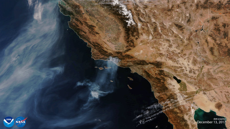
first True Color rendering of data from NOAA-20’s Visible Infrared Imaging Radiometer Suite (VIIRS) instrument, which showed the Thomas wildfire on Dec. 13, 2017, one of the largest in California’s history.
Summary
[edit].png&action=edit§ion=1)
| Description |
English: The image above is the first True Color rendering of data from NOAA-20’s Visible Infrared Imaging Radiometer Suite (VIIRS) instrument, which showed the Thomas wildfire on Dec. 13, 2017, one of the largest in California’s history. It was taken as part of the satellite’s on-orbit checkout process. VIIRS scans the entire planet twice per day at a 750-meter resolution; multiple visible and infrared channels allow it to detect atmospheric aerosols such as dust, smoke, and haze. |
| Date |
29 May 2020 (upload date) Taken on 13 December 2017 |
| Source | NOAA’s Newest Polar-Orbiting Satellite Celebrates a Milestone |
| Author | NOAA |
Licensing
[edit].png&action=edit§ion=2)
This image is in the public domain because it contains materials that originally came from the U.S. National Oceanic and Atmospheric Administration, taken or made as part of an employee's official duties.
|
File history
Click on a date/time to view the file as it appeared at that time.
| Date/Time | Thumbnail | Dimensions | User | Comment | |
|---|---|---|---|---|---|
| current | 15:27, 1 June 2024 | | 1,920 × 1,080 (1.12 MB) | OptimusPrimeBot (talk | contribs) | #Spacemedia - Upload of https://nesdis-prod.s3.amazonaws.com/migrated/20171213_NOAA20.png via Commons:Spacemedia |
You cannot overwrite this file.
File usage on Commons
There are no pages that use this file.
.png&oldid=880604811)