File:NMVB Zuid Namen.png
Jump to navigation
Jump to search

Size of this preview: 785 × 599 pixels. Other resolutions: 315 × 240 pixels | 629 × 480 pixels | 1,006 × 768 pixels | 1,280 × 977 pixels | 2,560 × 1,954 pixels | 3,420 × 2,611 pixels.
Original file (3,420 × 2,611 pixels, file size: 1.13 MB, MIME type: image/png)
Captions
Captions
Add a one-line explanation of what this file represents
Summary
[edit]| Description |
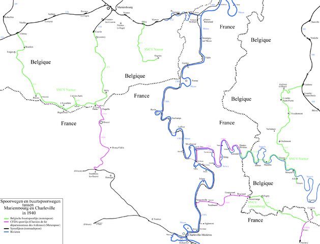
English: Map of the vicinal railways in the South of the province of Namur. |
| Date | |
| Source | Own work |
| Author | Smiley.toerist |
| Other versions |
.png)
.png)
Licensing
[edit]
I, the copyright holder of this work, hereby publish it under the following licenses:

|
Permission is granted to copy, distribute and/or modify this document under the terms of the GNU Free Documentation License, Version 1.2 or any later version published by the Free Software Foundation; with no Invariant Sections, no Front-Cover Texts, and no Back-Cover Texts. A copy of the license is included in the section entitled GNU Free Documentation License. |
This file is licensed under the Creative Commons Attribution-Share Alike 3.0 Unported, 2.5 Generic, 2.0 Generic and 1.0 Generic license.
- You are free:
- to share – to copy, distribute and transmit the work
- to remix – to adapt the work
- Under the following conditions:
- attribution – You must give appropriate credit, provide a link to the license, and indicate if changes were made. You may do so in any reasonable manner, but not in any way that suggests the licensor endorses you or your use.
- share alike – If you remix, transform, or build upon the material, you must distribute your contributions under the same or compatible license as the original.
You may select the license of your choice.
File history
Click on a date/time to view the file as it appeared at that time.
| Date/Time | Thumbnail | Dimensions | User | Comment | |
|---|---|---|---|---|---|
| current | 10:20, 24 August 2010 | | 3,420 × 2,611 (1.13 MB) | Smiley.toerist (talk | contribs) | Eind versie |
| 14:25, 23 August 2010 |  | 3,420 × 2,611 (1,015 KB) | Smiley.toerist (talk | contribs) | Derde versie: 3 CFDA zijn nu klaar met de spoorweg en de Maas tot bijna bij Charleville. | |
| 12:33, 20 August 2010 |  | 3,420 × 2,611 (862 KB) | Smiley.toerist (talk | contribs) | Monthermé lijn erbij + het Noorden | |
| 13:56, 19 August 2010 |  | 3,420 × 2,611 (726 KB) | Smiley.toerist (talk | contribs) | {{Information |Description={{en|1=Map off the vicinal railways in the South of the province of Namur. This map is not finished and the French side wil be filled in.}} |Source={{own}} |Author=Smiley.toerist |Date=2010-08-19 |Permiss |
You cannot overwrite this file.
File usage on Commons
The following 3 pages use this file:
File usage on other wikis
The following other wikis use this file:
- Usage on cs.wikipedia.org
- Usage on de.wikipedia.org
- Usage on fr.wikipedia.org
- Société nationale des chemins de fer vicinaux
- Discussion utilisateur:Smiley.toerist
- Ligne de Soissons à Givet
- Wikipédia:Le Bistro/24 août 2010
- Chemins de fer départementaux des Ardennes
- Lignes de tramway de la SNCV dans la province de Namur
- Utilisateur:Arflhn/Brouillon 5
- Ligne de tramway 453/1
- Ligne de tramway 553
- Ligne de tramway 451
- Ligne de tramway 453/2
- Usage on nl.wikipedia.org